Rockall Basin facts for kids

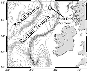
The Rockall Trough is a very deep part of the ocean floor located northwest of Scotland and Ireland. It stretches from the southwest to the northeast. To its north is the Rockall Plateau, and to its south is the Porcupine Seabight. At its northern end, the trough meets the Wyville-Thomson Ridge, which is named after Charles Wyville Thomson. He was a professor who led the famous Challenger Expedition to explore the oceans.
At the southern end, the Rockall Trough opens up into the Porcupine Abyssal Plain, which is a very flat and deep area of the ocean floor. Underneath the trough lies the Rockall Basin, also called the Hatton Rockall Basin. This is a huge area, about 800 kilometers long and 150 kilometers wide, filled with layers of sediment. Both the trough and the basin are named after Rockall, a small rocky island located about 300 kilometers west of St Kilda.
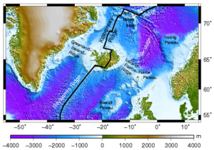
Interestingly, some features on the Rockall Plateau have been named after places from J. R. R. Tolkien's famous books, like Middle-earth. You can find places like Eriador Seamount, Rohan Seamount, Gondor Seamount, Fangorn Bank, Edoras Bank, Lorien Knoll, and Isengard Ridge.
In February 2000, a British research ship called the RRS Discovery was sailing in the Rockall Trough. It recorded the biggest waves ever measured by scientific tools in the open ocean. The average height of the waves was about 18.5 meters (61 feet), and some individual waves reached an amazing 29.1 meters (95 feet) tall!
How the Ocean Floor Formed Here
Scientists have long discussed what the Earth's crust is like under the Rockall Trough. At first, many thought it was oceanic crust, which is usually thinner. But now, most experts believe it is actually very stretched-out continental crust. This means it's like land that has been pulled apart a lot. However, some researchers still think it might be oceanic crust or a mix of both, especially in the southern part.
The Rockall Basin is part of a series of deep valleys, called rift basins, that formed a long time ago during the Mesozoic Era (the time of dinosaurs). These basins stretch between the Charlie-Gibbs Fracture Zone and the Senja Fracture Zone. Other basins in this chain include the Faroe-Shetland Basin and the Møre Basin. Scientists think the Rockall Basin might have started forming even earlier, perhaps during the Triassic or Middle Jurassic periods. The exact age when the main part of the Rockall Basin formed is still debated, with different ideas suggesting it happened in the Late Jurassic or various times during the Cretaceous period.
One special feature in the Rockall Trough is the Anton Dohrn Seamount. A seamount is an underwater mountain. This one sits about 600 meters (2,000 feet) below the ocean surface and rises 1,500 meters (4,900 feet) from the surrounding seabed. It formed about 55 million years ago when the ancient continent of Laurasia split apart due to plate tectonics. The small island of Rockall is the highest point of this underwater plateau, sticking out 21 meters (69 feet) above sea level. It is made of a type of rock called granite.
Oil and Gas Resources
So far, not much drilling has been done to find oil and gas in the Rockall Basin. Only two discoveries have been made: Benbecula in the UK part of the Rockall area and Dooish in the Irish part. These discoveries show that there is oil and gas present, at least in some places. However, different countries like the United Kingdom, Ireland, Iceland, and the Faroe Islands (which belong to Denmark) all claim rights to these resources. This disagreement is known as the Rockall Bank dispute.
Ocean Life and Protection
Quick facts for kids Hatton-Rockall Basin MPA |
|
|---|---|
|
IUCN Category IV (Habitat/Species Management Area)
|
|

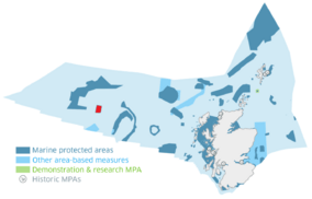
The location and size of the Hatton-Rockall Basin MPA, shown in red
|
|
| Location | North Atlantic, Scotland |
| Area | 1,256 km2 (485 sq mi) |
| Designation | Scottish Government |
| Established | 2014 |
| Operator | Marine Scotland |
The Rockall Trough is home to amazing deep-sea creatures. It has large groups of cold-water coral and special mounds made of carbonate, like the Logachev Mounds. The trough also supports many different kinds of deep-sea fish.
You can also find unusual groups of deep-sea sponges here, especially the encrusting sponge and the bird’s nest sponge. Many other species live among these sponge beds, making them important places for biodiversity. For example, near the bird’s nest sponges, you might find sea squirts, tiny Foraminifera, polychaete worms, and burrowing anemones. Around the encrusting sponge beds, there are anemones, sea squirts, sea lilies, and brittle stars. Brittle stars are filter feeders, meaning they get their food by filtering water as it passes by. They live on the seabed.
Because of its unique and important marine life, a large area of the Hatton-Rockall Basin, covering 1,256 square kilometers (485 square miles), was made a Nature Conservation Marine Protected Area in 2014. This area is recognized as a protected area by the International Union for the Conservation of Nature.
 | Georgia Louise Harris Brown |
 | Julian Abele |
 | Norma Merrick Sklarek |
 | William Sidney Pittman |


