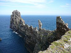
Tory Island facts for kids
Quick facts for kids
Toraigh
Tory Island
|
|
|---|---|
|
Island
|
|
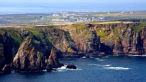
An aerial view of Tory Island
|
|
| Country | Ireland |
| Province | Ulster |
| County | County Donegal |
| Area | |
| • Total | 3.18 km2 (1.23 sq mi) |
| Population | |
| • Total | 119 |
| • Density | 37.42/km2 (96.9/sq mi) |
| Time zone | UTC+0 (WET) |
| • Summer (DST) | UTC-1 (IST (WEST)) |
| Area code(s) | 074, +353 74 |
| Irish Grid Reference | B853466 |
| As this is a Gaeltacht, Toraigh is the only official name. | |
Tory Island, also called Tory, is a small island off the northwest coast of County Donegal, Ireland. Its official Irish name is Toraigh. It is the most remote island in Ireland where people live. The name 'Tory' comes from an old Irish word, Tóraidhe, which means “bandit.”
Contents
Island Language
The main language spoken on Tory Island is Irish. However, people also speak English, especially to talk with visitors. Tory is part of the Donegal Gaeltacht. This means it is an area where Irish is the main language. The type of Irish spoken here is called Ulster Irish.
Island Geography and Travel
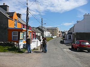
Tory Island is about 5 kilometers (3 miles) long and 1 kilometer (0.6 miles) wide. Its total area is about 3.5 square kilometers (1.38 square miles). In 2016, 119 people lived on the island. This was a small drop from 144 people in 2011. The island has four main towns: An Baile Thoir (East Town), An Baile Thiar (West Town), An Lár (Middletown), and Úrbaile (Newtown).
You can buy petrol and diesel on Tory Island. However, these fuels cost more than on the mainland.
Tory Island does not have an airport. But, you can travel there by ferry from mainland County Donegal. The ferry runs every day all year. It does not carry cars, but it can hold up to 70 passengers. Sometimes, in winter, the sea is too rough for the ferry to sail. From November to March, a small helicopter flies every other Thursday. It carries four people between Falcarragh and Tory.
Island History
Ancient Times
Old Irish stories say that Tory Island was once home to the Fomorians. These were mythical giants. Their leader, Conand, had a tower here. Later, the Fomorian king, Balor of the evil eye, also lived on Tory. He was said to have kept his daughter, Ethlinn, in a tower on Tor Mór. This is the highest point on the island.
A monastery was built on Tory Island in the 6th century. Colmcille founded it. This monastery was very important to island life. But in 1595, English soldiers attacked and destroyed it. They were fighting against local leaders at the time. The monastery's bell tower, built in the 6th or 7th century, is the largest part that still stands.
Later History
In 1608, during the Siege of Tory Island, some rebels hid in the island's castle. They started fighting each other, hoping to get a pardon from the English.
The last battle of the Irish rebellion of 1798 happened near Tory Island. This was a naval battle fought at sea.
Recent Events
During World War I, the British battleship HMS Audacious sank off Tory Island. This happened on October 27, 1914. A German naval mine caused the sinking. The British government kept this loss a secret until after the war ended in 1918. Passengers on the RMS Olympic, a ship like the Titanic, saw the sinking and took photos.
Since the 1950s, Tory Island has been home to artists. It even has its own art gallery. A famous English artist, Derek Hill, worked with the Tory artists.
Tory Island has a special tradition: the islanders choose a "king." This "King of Tory" (Rí Thoraí in Irish) does not have legal power. But he acts as a spokesperson for the island and welcomes visitors. The most recent king was the painter Patsy Dan Rodgers. He was king from the 1990s until he passed away in 2018.
Today, three diesel generators produce electricity for the island. They use about 500 liters of fuel each day.
In 2009, a former island resident won a court case. His house had been torn down and turned into a car park. He received money for the damage. In 2015, the island's only café was destroyed by fire.
Population Changes
The table below shows how Tory Island's population has changed over time.
| Historical population | ||||||||||||||||||||||||||||||||||||||||||||||||||||||||||||||||||||||||||||||||||||||
|---|---|---|---|---|---|---|---|---|---|---|---|---|---|---|---|---|---|---|---|---|---|---|---|---|---|---|---|---|---|---|---|---|---|---|---|---|---|---|---|---|---|---|---|---|---|---|---|---|---|---|---|---|---|---|---|---|---|---|---|---|---|---|---|---|---|---|---|---|---|---|---|---|---|---|---|---|---|---|---|---|---|---|---|---|---|---|
|
|
|
||||||||||||||||||||||||||||||||||||||||||||||||||||||||||||||||||||||||||||||||||||
| Source: | ||||||||||||||||||||||||||||||||||||||||||||||||||||||||||||||||||||||||||||||||||||||
Island Attractions
Tory Island has many interesting places. These spots are linked to historical events and island myths.
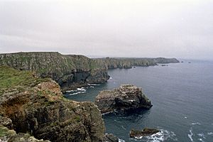
- Dún Bhaloir (“Balor's Fort”) is on the east side of the island. It sits on a peninsula with 90-meter (300-foot) high cliffs on three sides. You can only reach the fort by crossing a narrow strip of land. This strip is protected by four earth walls.
- An Eochair Mhór (the “Big Key”) is a long, steep rock formation. It sticks out from the east side of the peninsula. It ends in a tall rock called An Tor Mór (the “Big Rock”). This formation has rocky peaks known as “Balor's soldiers.” These peaks make it look like a key, giving it its name.
- The Wishing Stone is a flat rock next to the northern cliff of Balor's Fort. People say if you step onto this rock, your wish will come true. You can also make a wish if you throw three stones onto it.
- An Cloigtheach (the “Bell Tower”) is the largest part of the monastery that survived. It was built in the 6th or 7th century.
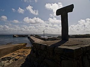
- The Tau Cross is a T-shaped cross. It is believed to be from the 12th century. It is one of only two Tau crosses in Ireland.
- Móirsheisear (“Grave of the Seven”) is a tomb. It holds seven people, six men and one woman. They drowned when their boat overturned off the island's northwest coast. Local stories say that clay from the woman's grave can keep away pests.
- The Lighthouse stands at the west end of the island. It was built between 1828 and 1832. A famous lighthouse designer, George Halpin, created its plan. In 1990, the lighthouse became automated. It is one of three lighthouses in Ireland with a special GPS system.
- The Torpedo can be seen between An Baile Thiar and An Baile Thoir. It washed ashore during World War II. It was made safe and moved to its current spot.
Island Wildlife
Tory Island is a special place for birds. It is called an “Important Bird Area.” It is a breeding ground for corn crakes. These birds are globally threatened. Their numbers have dropped as farming has changed. In 2007, 18 male corn crakes were heard calling on Tory Island. This was down from 34 in 2003. By 2010, only 10 were heard. Many other rare birds also visit the island.
Old notes from George Crawford Hyndman describe the island's plants and animals. Some types of algae found there include Fucus vesiculosus, Fucus nodosus, and Laminaria digitata.
Because of strong winds, Tory Island has no trees.
See also
 In Spanish: Isla Tory para niños
 | Delilah Pierce |
 | Gordon Parks |
 | Augusta Savage |
 | Charles Ethan Porter |


