
Ross-shire facts for kids
Quick facts for kids
Ross-shire
|
||
|---|---|---|
|
||
 |
||
| Sovereign state | ||
| Country | ||
| County town | Dingwall | |
| Area | ||
| • Total | 3,089 sq mi (8,000 km2) | |
| Ranked 3rd of 34 | ||
| Chapman code |
ROC (as part of Ross and Cromarty)
|
|

Ross-shire (pronounced 'ross-shy-er') is a historic county located in the Scottish Highlands. It's a really old area of Scotland with a long history. To the north, it shares a border with Sutherland. To the south, it borders Inverness-shire.
Ross-shire also has a tricky border with Cromartyshire. Cromartyshire was made up of many small pieces of land scattered inside Ross-shire. Ross-shire includes most of the area called Ross. It also includes Lewis, which is part of the Outer Hebrides islands. The main town of Ross-shire has always been Dingwall.
For a long time, Ross-shire was managed by a special judge called a sheriff. This area was separated from Inverness by the Scottish Parliament. Later, in 1889, Ross-shire and Cromartyshire were joined together. They became one big area called Ross and Cromarty. This new area was used for local government until 1975. Even after that, Ross-shire was still used as a postal address for many years.
In 1975, the area changed again. Ross and Cromarty became part of the larger Highland region. This region then became a single council area in 1996.
Ross-shire also had its own representatives in the British Parliament. From 1708 to 1832, it was a separate voting area. Then, it joined with Cromartyshire to form the Ross and Cromarty voting area.
Contents
Exploring Ross-shire's Geography

Ross-shire is a place of amazing natural beauty. It has two main parts: the west and the east.
Wester Ross: Mountains and Coasts
The western part of Ross-shire is known as Wester Ross. It's famous for its tall, rugged mountains. These include the impressive Torridon Hills, with peaks like Beinn Eighe and Liathach. The very highest point in the county is Càrn Eighe, which stands at 1,183 meters (3,881 feet) tall.
Wester Ross also has a long, broken coastline. It faces The Minch and Inner Sound, which are waters near the Skye island. This coastline has many isolated peninsulas. These are pieces of land almost surrounded by water. They are separated by deep sea lochs, which are like long, narrow sea inlets. Some of these sea lochs include Loch Broom, Little Loch Broom, Loch Ewe, Loch Gairloch, Loch Torridon, Loch Kishorn, Loch Carron, Loch Long, and Loch Duich.
Easter Ross: Flat Lands and Farmland
The eastern part of Ross-shire is called Easter Ross. This area is much flatter than the west. It has many towns, villages, and farms. It borders the Moray Firth, which is a large bay.
In the north, the Dornoch Firth separates Ross-shire from Sutherland. The Tarbat peninsula is a hammerhead-shaped piece of land in the north-east. It is shared with Cromartyshire. Across the Cromarty Firth is the Black Isle. This is actually a peninsula, not an island, and it's also shared with Cromartyshire. To the south-east, the Beauly Firth forms the border with Inverness-shire.
Lakes and Islands
Ross-shire is home to many beautiful lakes, called lochs in Scotland. Some of the most well-known include Loch Maree, Loch Fannich, Fionn Loch, Loch Eye, Loch Glass, and Loch Luichart.
Lewis is the northern part of a much larger island. It's the biggest island in the Outer Hebrides. Because its land is flatter and more fertile, most of the people in the Western Isles live on Lewis. The largest town there is Stornoway. Far out to the west are the Flannan Isles, which are uninhabited. Even further north, about 71 kilometers (44 miles) from the Butt of Lewis, are North Rona and Sula Sgeir. These remote islands are also part of Ross-shire.
Islands of Mainland Ross-shire
- A' Ghlas-Leac
- An Garbh-Eilean
- Black Islands
- Crowlin Islands
- Eilean a' Chait
- Eilean a' Mhal
- Eilean an Inbhire Bhàin
- Eilean an t-Sratha
- Eilean Bàn
- Eilean Chuaig
- Eilean Dubh Dhurinis
- Eilean Furadh Mòr
- Eilean Horrisdale
- Eilean Mòr
- Eilean na Bà
- Eilean na Bà Mòr
- Eilean na Beinne
- Eilean na Creige Duibhe
- Eilean nam Feannag
- Eilean nan Naomh
- Eilean Stacan
- Eilean Tioram
- Eileanan Dubha
- Fraoch Eilean
- Fraoch Eilean Mòr
- Glas Eilean
- Gruinard Island
- Isle of Ewe
- Kishorn Island
- Làrach Tigh Mhic Dhomhnuill
- Longa Island
- Sgeir a' Bhuic
- Sgeir a' Ghair
- Sgeir an Araig
- Sgeir an Fheòir
- Sgeir Bhuide
- Sgeir Bhuidhe
- Sgeir Chreagach
- Sgeir Dùghaill
- Sgeir Fhada
- Sgeir Ghlas
- Sgeir Maol Mhoraidh
- Sgeir Maol Mhoraidh Shuas
- Sgeir na Trian
- Shieldaig Island
- Strome Islands
- Ulluva
Islands of Lewis
- Àird Orasaigh
- Bearasaigh
- Bhuaile Mhòr
- Bràighe Mòr
- Bratanais Mòr
- Campaigh
- Ceabagh
- Ceabhaigh
- Cealasaigh
- Cliatasaigh
- Craigeam
- Cruitear
- Cùl Campaigh
- Eilean a' Bhlàir
- Eilean an Tighe
- Eilean Àrnol
- Eilean Beag a' Bhàigh
- Eilean Bhàcasaigh
- Eilean Bhinndealaim
- Eilean Chearstaigh
- Eilean Chalaibrigh
- Eilean Chaluim Cille
- Eilean Cheòis
- Eilean Dubh a' Bhàigh
- Eilean Fir Chrothair
- Eilean Liubhaird
- Eilean Mhealasta
- Eilean Molach
- Eilean Mòr a' Bhàigh
- Eilean Mòr Lacasaidh
- Eilean Mòr Phabail
- Eilean nan Uan
- Eilean Orasaidh
- Eilean Orasaigh
- Eilean Rosaidh
- Eilean Sgarastaigh
- Eilean Shìophoirt
- Eilean Teinis
- Eilean Thinngartsaigh
- Eilean Thòraidh
- Eilean Thuilm
- Eilean Trosdam
- Eughlam
- Eunaigh Mòr
- Flannan Isles
- Fleisgeir
- Flodaigh, Lewis
- Flodaigh (Outer Loch Ròg)
- Fuaigh Beag
- Fuaigh Mòr
- Garbh Eilean
- Geile Sgeir
- Glas Sgeir
- Gousam
- Great Bernera
- Grèineam
- Hairsgeir Beag
- Hairsgeir Mòr
- Lada Sgeir
- Langaisgeir Mòr
- Lewis (part of the larger Lewis and Harris island)
- Linngeam
- Liongam
- Lìth Sgeir
- Little Bernera
- Màs Sgeir
- Pabaigh Beag
- Pabaigh Mòr
- Riosaigh
- Seanna Chnoc
- Sgeir a' Mhurain
- Sgeir Dhail
- Sgeir Dhearg
- Sgeir Ghlas Bheag
- Sgeir Ghobhlach
- Sgeir Leathann
- Sgeir Liath
- Sgeir Mhòr Shildinis
- Sgeir Mol Srupair
- Sgeir Sgianailt
- Sgeir Tanais
- Sgeirean An Arbhair
- Shiant Islands
- Siaram Bostadh
- Siaram Mòr
- Tabhaigh Bheag
- Tabhaigh Mhòr
- Tamna
- Tanaraigh
- Tannaraidh
- Thalta Sgeir
- Vacsay (Bhàcasaigh in Gaelic)
Islands of North Rona
- Ghealldraig Mhòr
- Gralisgeir
- Lisgear Mhòr
- North Rona
- Sula Sgeir
- Thamna Sgeir
Towns and Villages
Ross-shire has many towns and villages, both on the mainland and on the Isle of Lewis.
Mainland Settlements


- Achnasheen
- Alness
- Applecross
- Ardgay
- Aultbea
- Avoch
- Ballintore
- Barbaraville
- Conon Bridge
- Contin
- Culrain
- Diabaig
- Dingwall
- Dornie
- Easter Fearn
- Edderton
- Evanton
- Fearn
- Fortrose
- Garve
- Gairloch
- Hill of Fearn
- Invergordon
- Inverinate
- Kilmuir, Black Isle
- Kilmuir, Easter Ross
- Kinlochewe
- Kyle of Lochalsh
- Laide
- Marybank
- Marburgh
- Muir of Ord
- Mulbuie
- Munlochy
- Nigg
- North Kessock
- Poolewe
- Reraig
- Shieldaig
- Strathcarron
- Strathpeffer
- Stromeferry
- Tain
- Torridon
Isle of Lewis Settlements

- Achmore
- Adabrock
- Aignish
- Aird
- Aird Uig
- Airidhbhruaich
- Arnol
- Back
- Balallan
- Ballantrushal
- Barvas
- Borve
- Bragar
- Branahuie
- Brue
- Breaclete
- Breanish
- Breasclete
- Calbost
- Callanish
- Carishader
- Carloway
- Caverstay
- Cliff
- Coll
- Cromore
- Cross
- Crossbost
- Crowlista
- Dalbeg
- Eagleton
- Eorodale
- Eoropie
- Fivepenny
- Flesherin
- Garynahine
- Garyvard
- Geishader
- Gisla
- Gravir
- Gress
- Grimshader
- Habost
- Hacklete
- Holm
- Islivik
- Keose
- Keose Glebe
- Kershader
- Kirkibost
- Kneep
- Knockaird
- Laxay
- Laxdale
- Lemreway
- Leurbost
- Lionel
- Lower Bayble
- Mangursta
- Marvig
- Marybank
- Meavik
- Melbost
- Newmarket
- Newvalley
- North Dell
- North Galson
- North Tolsta
- Orinsay
- Parkend
- Plasterfield
- Portnaguran
- Port of Ness
- Portvoller
- Ranish
- Sandwick
- Shader
- Shawbost
- Sheshader
- Shieldenish
- Shulishader
- Skigersta
- South Dell
- South Galson
- Steinish
- Stornoway
- Swainbost
- Timsgarry
- Tobson
- Tong
- Upper Bayble
- Valtos
Images for kids
-
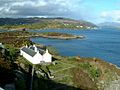
Eilean Bàn from the Skye Bridge, looking towards Kyle of Lochalsh
-
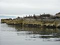
Shag birds on Longa Island
-
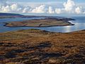
The Isle of Ewe
-
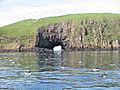
Cave on Garbh Eilean, Shiant Isles
-
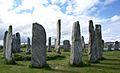
The famous Callanish Stones on Lewis
-
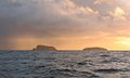
Seana Chnoc (at left) and Bearasaigh from the south west. Stac nam Balg is just visible to the left of Seanna Chnoc


See also
- Mormaer of Ross
- Bishop of Ross
- James McKenzie
