The Minch facts for kids
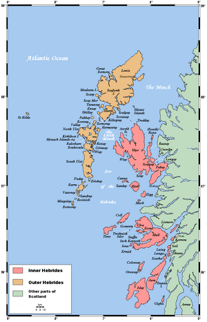
The Minch is a wide stretch of water, like a big channel, in northwest Scotland. It is also called the North Minch. This channel separates the northwest Scottish Highlands and the northern Inner Hebrides islands from the islands of Lewis and Harris in the Outer Hebrides. Long ago, people speaking Old Norse called it Skotlandsfjörð, which means "Scotland's fjord" or "firth".
There is also the Lower Minch, sometimes called the Little Minch. This is the southern part of the Minch. It separates the Isle of Skye from the southern Outer Hebrides islands. These islands include North Uist, Benbecula, South Uist, and Barra. The Little Minch connects to the Sea of the Hebrides in the south.
Contents
Exploring the Minch's Geography
The Minch is about 14 to 45 miles (23 to 72 kilometers) wide. It stretches for about 70 miles (113 kilometers) in length. Scientists believe this area was hit by the biggest meteorite ever to strike the British Isles. The Little Minch is about 15 miles (24 kilometers) wide.
In June 2010, a person named Eilidh Macdonald made history. She was the first to swim across the Little Minch. She swam from Waternish Point on Skye to Rodel on Harris. It took her about 9.5 hours to complete this amazing swim.
The Little Minch has a special system for ships. It's called a traffic separation scheme. This means ships going north stay close to Skye. Ships going south stay close to Harris. This helps keep the busy shipping lane safe.
Large ferry boats also cross the Minch. These services are run by a company called Caledonian MacBrayne. They help people travel between the mainland and the islands.
Important Lighthouses
Lighthouses are like tall towers with bright lights. They help guide ships safely, especially at night or in bad weather.
- In the south, lighthouses at Barra Head, Ushenish, and Hyskeir mark the entrance.
- On the Isle of Skye, you can see lights at Neist Point, Vaternish, and An t-Iasgair.
- The Outer Hebrides have lights at Weavers Point, Eilean Glas, Tiumpan Head, and Butt of Lewis.
- To the east, there are lighthouses at Rubh Re, Stoer Head, and Cape Wrath.
Sometimes, there are hidden rocks or shallow areas in the water. A special floating marker, called a buoy, helps ships avoid these dangers. For example, a buoy marks Eugenie Rock and Sgeir Graidach. These spots were named after a ship that got stuck there long ago.
Minch Mythology: Blue Men
Local stories tell of the blue men of the Minch. These are mythical creatures said to live in the waters of the Minch. They are like sea fairies or spirits.
Protecting the Minch's Environment
The Minch is a very important place. It is home to lots of wildlife, like dolphins. Because of this, a group called the Minch Project works to protect it. This project is a team effort. It includes local councils and Scottish Natural Heritage.
Their main goals are:
- To reduce pollution in the water.
- To stop the land from wearing away (called erosion).
- To keep the area clean by minimizing litter.
- To encourage tourism, especially for people who want to see the amazing wildlife.
Pollution is a big worry because many ships pass through the Minch. About 2.5 million tonnes of goods are carried by ships through this channel every month. This makes it a very busy shipping lane.
See also
 In Spanish: El Minch para niños
 | Delilah Pierce |
 | Gordon Parks |
 | Augusta Savage |
 | Charles Ethan Porter |


