
Cape Wrath facts for kids
Quick facts for kids Cape Wrath |
|
|---|---|
| Am Parbh (Scottish Gaelic) | |

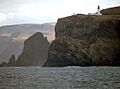
Cape Wrath from the sea
|
|

Location in Scotland
|
|
| Location | Scotland |
| Coordinates | 58°37′N 5°00′W / 58.62°N 5.00°W |
Cape Wrath is a famous cape in the Highlands of Scotland. It's known as Am Parbh in Scottish Gaelic. This cape is the most north-westerly point on the mainland of Britain.
Cape Wrath is separated from the rest of the mainland by the Kyle of Durness, which is a sea inlet. The area is mostly wild moorland, covering about 107 square miles (277 square kilometres). This wilderness is called the Parph. The first road here was built in 1828 to connect a ferry across the Kyle of Durness to the buildings on the peninsula.
A large part of Cape Wrath is owned by the Ministry of Defence. They use it as a military training area, including a place for live firing exercises. However, parts of the cape are also special protected areas. These include a Site of Special Scientific Interest, a Special Protection Area, a Special Area of Conservation, and a Special Landscape Area.
Contents
What's in a Name?
The name Cape Wrath comes from an old Norse word, hvarf. This word means "turning point." Vikings are thought to have used the cape as an important spot to turn their ships when sailing. That's why "wrath" is pronounced with the "a" sound like in "cat."
Cape Wrath's Past

Long ago, Cape Wrath was home to small farming communities called crofting communities. By the mid-1800s, only shepherd families lived on the Parph. In the 1930s, about 30 to 40 people lived here. There was even a small school at Achiemore until 1947. Some old building remains at places like Kearvaig date back to the 1700s.
Most of the land has been used for sheep grazing, which still happens today. You can find old shelters called shielings, built for shepherds, all over the cape. The population dropped a lot in the mid-1900s. Now, almost no one lives there, but the military and tourists still use the area. The Cape Wrath Lighthouse was built in 1828, and the road to it was built around the same time. A Lloyd's of London signal station was also built near the lighthouse in the late 1800s to keep track of ships.
In 1915, a ship called HMS Caribbean sank off Cape Wrath during bad weather. It was a former passenger ship used for wartime. Fifteen people died. The wreck was found in 2004, about 35 miles (56 km) off the cape.
Exploring the Geography

Cape Wrath is located in the Highland Region of Scotland. The closest village is Durness, about 10 miles (16 km) to the southeast. Inverness is much further south, about 120 miles (193 km) away.
The sea cliffs around the cape are made of Torridonian sandstone and Lewisian gneiss. These cliffs are very tall, reaching up to 281 metres (922 ft) above sea level. Some of the highest sea cliffs in mainland Britain are here, at Clò Mòr. You can also see tall sea stacks, which are rock pillars rising out of the sea. Duslic, a reef, is about 5/8 mile (1 km) north of the cape. Cape Wrath is part of the North West Highlands Geopark, a special area recognized by UNESCO.
Small farming settlements once existed at Daill, Achiemore, Kearvaig, and Inshore. The land used to belong to the Duke of Sutherland. Today, the Ministry of Defence owns about 25,000 acres (10,000 ha) of the northern part of the peninsula. They use this land for military training.
Weather at the Cape
Cape Wrath has an oceanic climate, which means it has mild winters and cool summers. This is common for places on the western coast.
Because it's so far north and exposed, Cape Wrath can have very little sunshine in winter. For example, in January 1983, it only had 38 minutes of sunshine! But because it's on the coast, it rarely gets very cold compared to places further inland. Strong winds are also common, with gusts sometimes reaching 140 miles per hour (225 km/h).
| Climate data for Cape Wrath | |||||||||||||
|---|---|---|---|---|---|---|---|---|---|---|---|---|---|
| Month | Jan | Feb | Mar | Apr | May | Jun | Jul | Aug | Sep | Oct | Nov | Dec | Year |
| Record high °C (°F) | 16.1 (61.0) |
13.9 (57.0) |
17.8 (64.0) |
19.1 (66.4) |
24.4 (75.9) |
25.6 (78.1) |
26.0 (78.8) |
26.9 (80.4) |
23.9 (75.0) |
22.2 (72.0) |
16.0 (60.8) |
17.7 (63.9) |
26.9 (80.4) |
| Mean daily maximum °C (°F) | 6.5 (43.7) |
6.3 (43.3) |
6.9 (44.4) |
8.0 (46.4) |
10.8 (51.4) |
12.2 (54.0) |
14.2 (57.6) |
14.6 (58.3) |
12.9 (55.2) |
11.0 (51.8) |
8.5 (47.3) |
7.3 (45.1) |
9.9 (49.9) |
| Mean daily minimum °C (°F) | 2.3 (36.1) |
2.2 (36.0) |
2.6 (36.7) |
3.8 (38.8) |
6.1 (43.0) |
8.0 (46.4) |
10.0 (50.0) |
10.5 (50.9) |
9.0 (48.2) |
7.0 (44.6) |
4.4 (39.9) |
3.1 (37.6) |
5.8 (42.4) |
| Record low °C (°F) | −6 (21) |
−6.9 (19.6) |
−4.5 (23.9) |
−6 (21) |
−2 (28) |
1.6 (34.9) |
4.0 (39.2) |
4.1 (39.4) |
2.5 (36.5) |
−0.5 (31.1) |
−3 (27) |
−5.1 (22.8) |
−6.9 (19.6) |
| Average precipitation mm (inches) | 131.5 (5.18) |
77.7 (3.06) |
101.49 (4.00) |
62.87 (2.48) |
55.43 (2.18) |
70.49 (2.78) |
82.91 (3.26) |
100.44 (3.95) |
139.62 (5.50) |
138.28 (5.44) |
160.95 (6.34) |
138.31 (5.45) |
1,259.99 (49.62) |
| Source 1: YR.NO | |||||||||||||
| Source 2: Royal Dutch Meteorological Institute/KNMI 112 m (367 ft) above sea level, 1971–2000, Extremes 1960–2000 |
|||||||||||||
Amazing Wildlife and Nature


Cape Wrath is a wild place, mostly untouched by people. This means it has a wide variety of wildlife. You can find red deer, hooded crows, rock pipits, and large birds like golden eagles, cormorants, and gannets.
A large area of 1,019 hectares (2,518 acres) is a Special Protection Area (SPA) and a Site of Special Scientific Interest (SSSI). The cliffs are super important for over 50,000 seabirds that come here to nest. These include puffins, razorbills, guillemots, kittiwakes, and fulmars. The protected area also extends out to sea, covering the ocean where these birds find their food.
Sadly, the number of seabirds in the area has gone down a lot in recent years, with puffin numbers dropping by 50%. Other marine animals found here include harbour porpoises, common seals, and bottle-nosed dolphins.
The plants on the cliff tops include common scurvygrass. There are also different types of habitats, from sand dunes at the cape to mountain-like areas at sea level.
About 123 square kilometres (47 sq mi) of the coastline is a Special Landscape Area. This area stretches from Oldshoremore to Durness. Just offshore is Stac Clò Kearvaig, also called "The Cathedral" because it looks like two spires and a natural window. Garvie Island is another island nearby, often used as a target by the military.
Inland, the landscape is mostly covered in peat, which makes it boggy. There are also many small lakes called lochans. The biggest one is Loch Airigh na Beinne. This area is known as one of the few true coastal wildernesses in Britain. Plants like heather, juniper, and ferns grow here.
Cape Wrath Lighthouse
The lighthouse at Cape Wrath was built in 1828 by Robert Stevenson. It was operated by people until 1998, when it became automatic. The lighthouse is a 20-metre (66 ft) tall white tower made of granite. Its light is 122 metres (400 ft) above sea level and can be seen for 22 nautical miles (41 km).
Near the lighthouse, there are other buildings that were part of a signal station. These were built by Lloyd's of London between 1894 and 1903 to track ships. The station closed in 1932 but was used again during World War II as a coastguard station.
Military Training Area


The Ministry of Defence (MoD) owns about 59 square kilometres (23 sq mi) of the cape. This area is called the Cape Wrath Training Centre. The military has used the cape for training since the early 1900s. It was first used as a naval gunnery range and the MoD bought it in 1999.
Since 2005, the area has been used for training by different parts of the military (navy, army, air force). It's one of the places used for Exercise Joint Warrior, which is Europe's largest military exercise. NATO forces also use it. Training can happen up to 120 days a year, usually in spring and autumn. The training times can change. The area is usually open to the public in summer, and there is rarely firing on Sundays.
The MoD owns some of the buildings in the area. They set up observation posts during training. The area is used for naval gunfire practice and for army artillery and mortar firing. Old military vehicles are often used as targets. The Royal Air Force (RAF) uses Garvie Island as a target for training. This is the only place in the Northern Hemisphere where NATO forces practice land, air, and sea attacks together. They can use bombs up to 1,000 pounds (450 kg).
Sometimes, military exercises have caused problems. In 2008, a heath fire started during live firing, affecting about 137 hectares (339 acres). It was estimated to take 10 years for the area to recover. People have also worried about how military exercises affect nesting birds, sheep during lambing season, and noise for local residents. In 2002, a shell landed off-target near Loch Eriboll, close to houses, causing concern.
In 2012, the MoD wanted to buy more land around the lighthouse. But a local group, the Durness Development Group, opposed the plan. They worried that historic buildings might be destroyed and that visitors might not be able to access paths. Many people signed a petition against the sale. In May 2013, the MoD decided not to buy the land.
Visiting Cape Wrath

Between 2,000 and 6,000 tourists visit Cape Wrath each year. They are drawn by the wild landscape, the animals, the cliffs, the mountain views, and the lighthouse. Tourism brings a lot of money to the local area around Durness.
Cape Wrath is the starting or ending point for two long walking trails:
- The Cape Wrath Trail, which is about 200 miles (320 km) long and goes through very isolated country from Fort William.
- The Scottish National Trail, which is about 460 miles (740 km) long and starts from Kirk Yetholm on the Scottish border.
Cape Wrath is also the turning point for the Cape Wrath Marathon. The race goes 11 miles (18 km) to the lighthouse and then back to the ferry dock on the cape side. The last 4 miles (6 km) of the race are run from the mainland side, finishing at Durness Community Centre. The marathon is part of a week of races called the Cape Wrath Challenge.
The only people living on the Cape are the Ure family. They rent the main building and have turned it into a home. In 2009, they opened what is said to be Britain's most remote cafe, the Ozone Cafe. It was opened by the Princess Royal and can seat eight people.
The Durness Development Group has ideas to make Cape Wrath even better for visitors. They hope to increase the number of visitors to 10,000 and improve facilities at the cape.
Getting There

If you're coming from the south, the only way to reach the Cape on foot is from Sandwood Bay and Kinlochbervie. Sometimes, access is limited due to military operations.
A rough road, about 11 miles (18 km) long, connects the lighthouse to the Kyle of Durness. You can cross the Kyle of Durness by a passenger ferry that runs from May to September. The road was built in 1828 when the lighthouse was constructed. It crosses boggy areas and steep slopes using special stone paths and supports.
The road, known as the U70, passes through the small settlement of Achiemore. Here, a Ministry of Defence checkpoint can block access to the cape during live firing exercises. The road also passes old farmsteads like Daill and Inshore. A track leads off the main road to the old hamlet of Kearvaig, where there's a beach and Kearvaig House. This house has been turned into a bothy, which is a simple shelter for walkers. A minibus service runs along the road in the summer, taking people from the ferry to the lighthouse. The road, ferry, and minibus service all stop when military training is happening.
Images for kids
-
Cape Wrath from the sea
See also
 In Spanish: Cabo Wrath (Escocia) para niños
