Kyle of Durness facts for kids
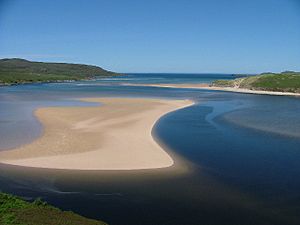
The Kyle of Durness is a long, narrow arm of the sea, also known as a coastal inlet, located on the northern coast of Scotland. It is found in the area called Sutherland. This inlet stretches about 9 kilometers (5.5 miles) inland from a place called Balnakeil. It acts like a natural border, separating the Cape Wrath peninsula from the rest of the mainland. The closest village to the Kyle of Durness is Durness.
Contents
Exploring the Kyle of Durness
The Kyle of Durness is about 800 meters (0.5 miles) wide. It is a tidal area, which means the water level changes a lot with the tides. At low tide, only a small channel of water remains along most of its length. Unlike many other coastal inlets in northern Scotland, the Kyle is not straight. It has two main bends near a spot called Keoldale.
Where the Kyle Meets the Sea
The Kyle of Durness opens into a wider area called Balnakeil Bay. This bay is about 3 kilometers (2 miles) wide at its mouth. On the eastern side of the bay is a place called Faraid Head. This area is important because it helps control the military training zone at Cape Wrath, which is to the west.
Military Training Area
The waters north of Balnakeil Bay are part of a special danger zone. This area is used for military training exercises. The Royal Navy practices live firing here, and the RAF uses it for bombing practice. It's a busy place for military training.
Rivers and Landscape
Several rivers flow into the Kyle of Durness. The main ones are the River Dionard and the Grudie River, which join the Kyle at its southern end. Other smaller streams also flow into the Kyle along its sides. The eastern side of the Kyle has a lot of limestone rock, which creates beautiful rolling grasslands. The Kyle and the land around it are part of a special protected area called the Oldshoremore, Cape Wrath and Durness Special Landscape Area. This area also holds many old remains from prehistoric times, showing people lived here long ago.
Life and Travel Around the Kyle
A road called the A838 road runs along the eastern side of the Kyle in its southern part. From this road, a smaller road leads to Keoldale. Keoldale is the only place where people still live right on the shore of the Kyle.
Getting to Cape Wrath
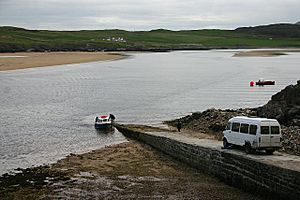
From Keoldale, you can catch a special passenger ferry. This ferry operates between May and September. It is the only way to get to Cape Wrath from the eastern side of the Kyle. This ferry is very important for visitors and locals.
Farming and Beaches
The land north of Keoldale is used by a group called the Keoldale Sheep Stock Club. This is a shared farm run by local farmers, known as crofters, from the Durness area. Along the shores of the Kyle, you'll find beaches backed by a type of grassy land called machair. There are not many sand dunes here.
The Western Shore
The western side of the Kyle is not lived on by people. The only signs of past settlements are old farmsteads at places like Achimore and Daill. The Cape Wrath road runs along this western shore, starting from where the ferry lands. This road was built in the 1830s to help supply the lighthouse at Cape Wrath. There was an older landing spot closer to the mouth of the Kyle, where you can still see the ruins of a storehouse.
 | James B. Knighten |
 | Azellia White |
 | Willa Brown |


