
Sutherland facts for kids
Quick facts for kids
Sutherland
Cataibh (Scottish Gaelic)
|
||
|---|---|---|
|
||
 |
||
| Sovereign state | ||
| Country | ||
| Council area | Highland | |
| County town | Dornoch | |
| Area | ||
| • Total | 2,028 sq mi (5,252 km2) | |
| Ranked 5th of 34 | ||
| Population
(2011)
|
||
| • Total | 12,650 | |
| • Density | 6.238/sq mi (2.4086/km2) | |
| Chapman code |
SUT
|
|

Sutherland (which is Scottish Gaelic: Cataibh in Scottish Gaelic) is a special area in the Scottish Highlands. It's known as a historic county, a registration county, and a lieutenancy area. Its main town is Dornoch. Sutherland is surrounded by Caithness and the Moray Firth to the east. To the south, it borders Ross-shire and Cromartyshire (which later became Ross and Cromarty). The Atlantic Ocean is to its north and west.
Sutherland has some of the most amazing scenery in Europe. This is especially true on its western side where tall sea cliffs meet the ocean. You can also find very old mountains made of ancient rocks there.
The name Sutherland comes from the time when Norwegian Vikings ruled much of the Highlands and Islands. Even though it's one of the most northern parts of Great Britain, the Vikings called it Suðrland, meaning "southern land". This was because they were looking at it from Orkney and Caithness. In Gaelic, different parts of Sutherland have their own names. For example, the northeast is called Dùthaich MhicAoidh, which means "MacAoidh's country". The west is called Asainte (Assynt), and the east is Cataibh. Sometimes, Cataibh is used for the whole area.
The northeast part of Sutherland, known as the Province of Strathnaver, became part of Sutherland in 1601. This was the home of the strong Clan Mackay. Even today, this area is called Mackay Country, and many people with the Mackay name still live there.
About 13,000 people live in Sutherland. Most of them live in small towns along the coast, like Helmsdale and Lochinver. These towns used to rely a lot on fishing. Sutherland is not as wealthy as some other parts of Scotland. There aren't many jobs outside of government work, farming, and tourism. For higher education, students can go to North Highland College. This college is part of the University of the Highlands and Islands. Its campus in Dornoch was the first place in the UK to offer a degree in golf management! Another campus in Dornoch, Burghfield House, teaches undergraduate and postgraduate history degrees.
Contents
Exploring Sutherland's Landscape


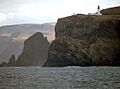
Sutherland's inland areas are wild and have very few people. Even though it's the fifth-largest county in Scotland by size, it has fewer people than a medium-sized town in the Scottish Lowlands. The county stretches from the Atlantic Ocean in the west to the North Sea in the east. The coastline has very high cliffs and deep inlets called fjords in the east and north. The west has jagged inlets, and the north has sandy beaches. The far northwest tip of Sutherland is Cape Wrath, which is the most northwesterly point in Scotland.
You'll find many peninsulas along the north and west coasts. Some of these are Strathy Point, A' Mhòine, and Durness/Faraid Head. The county also has many beautiful beaches. One remote example is Sandwood Bay, which you can only reach by walking along a rough path. Not many tourists visit this hidden gem.
Mountains and Geology
Sutherland has many rugged mountains. These include Ben Hope, which is the most northerly Munro (a Scottish mountain over 3,000 feet). Ben More Assynt is the tallest peak in the county, standing at 998 meters (3,274 feet). The western part of Sutherland is made of Torridonian sandstone sitting on top of even older rock called Lewisian gneiss. The amazing scenery here was formed by denudation, which is when rocks are worn away by weather and erosion. This process created isolated sandstone peaks like Foinaven, Arkle, Cùl Mòr, and Suilven. These mountains are great for hill walking and scrambling, even though they are in remote locations. They have a unique shape and offer many opportunities for exploration. However, it's important to be careful in bad weather because of their isolated location.
Wildlife and Natural Beauty
Sutherland was once home to the native wolf, with the last one reportedly shot in the 1700s. But other amazing wildlife still thrives here. You can spot golden eagles, sea eagles, and pine martens. These animals are very rare in other parts of the country. There are also small areas of native Scots Pine trees, which are what's left of the ancient Caledonian Forest.
The beautiful scenery of Sutherland is so important that four of Scotland's forty National Scenic Areas (NSAs) are located here. NSAs are special places identified for their exceptional beauty. They are protected to make sure they aren't damaged by new buildings or developments. These areas are considered to show the kind of beautiful scenery that Scotland is famous for.
The four NSAs in Sutherland are:
- The Assynt-Coigach NSA has many mountains with unique shapes. These include Quinag, Canisp, Suilven, Cùl Mòr, Stac Pollaidh, and Ben More Assynt. They rise steeply from the surrounding "cnoc and lochan" landscape (which means small hills and lochs). These mountains often look taller than they are because of their steep sides. Assynt is in Sutherland, while Coigach is in Ross and Cromarty.
- The Dornoch Firth NSA also crosses the border between Sutherland and Ross and Cromarty. It includes many different landscapes around the narrow and winding firth (a long, narrow inlet of the sea).
- The Kyle of Tongue NSA covers the mountains of Ben Hope and Ben Loyal. It also includes woodlands and small farming villages along the shore of the kyle itself.
- The North West Sutherland NSA includes the mountains of Foinaven, Arkle, and Ben Stack. It also features the coastal scenery around Loch Laxford and Handa Island.
Islands of Sutherland
Sutherland's coast is dotted with many islands. Here are some of them:
- A' Chleit
- A' Ghoil-sgeir
- Am Balg
- An Calbh
- An Cruachan
- An Dubh-sgeir
- An Garbh-eilean
- Boursa Island
- Calbha Beag
- Calbha Mòr
- Clach Mhòr na Faraid
- Clobh-sgeir
- Cùl Eilean
- Dubh Sgeir
- Dubh-Sgeir Mhòr
- Dubh Sgeirean
- Duslic
- Eilean a' Bhreitheimh
- Eilean a' Bhuic
- Eilean a' Chaoil
- Eilean a' Chonnaidh
- Eilean a' Ghamhna
- Eilean a' Mhadaidh
- Eilean an Achaidh
- Eilean an Aigeich
- Eilean an Eireannaich
- Eilean an Ròin Beag
- Eilean an Ròin Mòr
- Eilean an t-Sithein
- Eilean Àrd
- Eilean Choraidh
- Eilean Chrona
- Eilean Clùimhrig
- Eilean Dornaidh Oscair
- Eilean Dubh an Teoir
- Eilean Dubh Chal Cinn
- Eilean Dubh Dhrombaig
- Eilean Dubh na Fionndalach Bige
- Eilean Dubh nam Boc
- Eilea Garbh
- Eilean Hoan
- Eilean Iosal
- Eilean Meall a' Chaorainn
- Eilea na h-Aiteig
- Eilean na Coille
- Eilean na Bearachd
- Eilean na Rainich
- Eilean na Saille
- Eilean nam Boc
- Eilean nan Airbhe
- Eilean nan Ròn
- Eilean nan Uan
- Eilean Port a' Choit
- Eilean Rairidh
- Eilean Riabhach
- Eileanan Dubha
- Garbh-eilean
- Glas Leac
- Handa Island
- Meall Beag
- Meall Earca
- Meall Mòr
- Meall Thailm
- Na Cluasnadh
- Na Glas Leacan
- Neave Island
- Oldany Island
- Ox Rock
- Rabbit Islands
- Seana Sgeir
- Sgarbagh
- Sgeir a' Bhuic
- Sgeir a' Chlaidheimh
- Sgeir an Trilleachain
- Sgeir Iosal
- Sgeir Leathan
- Sgeir Liath
- Sgeir nan Gall
- Sgeir Ruadh
- Sgeirean Cruaidhe
- Sgeirean Glasa
- Soyea Island
Getting Around Sutherland
.jpg)
The main road on the east coast, the A9, can be tricky north of Helmsdale, especially at a difficult section called Berriedale Braes. There are also not many roads inland. A single-track railway line, the Far North Line, was built through Sutherland between 1868 and 1871. It runs along the east coast as much as possible.
Helmsdale on the east coast is on the A9 road and has a railway station. Buses run from Helmsdale to towns like Brora, Golspie, Dornoch, and Inverness to the south. They also go north to places like Thurso. These buses are operated by Stagecoach Group. Other Stagecoach buses connect towns like Lairg and Bonar Bridge to Tain and Inverness. The western parts of Sutherland have fewer public transport options. However, the Far North Bus company offers services connecting Durness to Lairg and Durness to Thurso along the north coast.
There are no large commercial airports in Sutherland. There's a small airstrip near Dornoch, but it doesn't see much air traffic.
The Highland Clearances
| Historical Sutherland population | ||
|---|---|---|
| Year | Pop. | ±% |
| 1801 | 23,117 | — |
| 1811 | 23,629 | +2.2% |
| 1821 | 23,840 | +0.9% |
| 1831 | 25,518 | +7.0% |
| 1841 | 24,782 | −2.9% |
| 1851 | 25,793 | +4.1% |
| 1861 | 24,157 | −6.3% |
| 1871 | 23,298 | −3.6% |
| 1881 | 22,376 | −4.0% |
| 1891 | 21,896 | −2.1% |
| 1901 | 21,440 | −2.1% |
| 1911 | 20,179 | −5.9% |
| 1921 | 17,802 | −11.8% |
| 1931 | 16,101 | −9.6% |
| 1951 | 13,670 | −15.1% |
| 1961 | 13,507 | −1.2% |
| 1971 | 13,055 | −3.3% |
| 2011 | 12,650 | −3.1% |
| Source: Vision of Britain | ||
Sutherland, like other parts of the Highlands, was greatly affected by the Highland Clearances. This was a time in the 18th and 19th centuries when landowners moved people from their homes and farms. They often did this to create large sheep farms. The Sutherland Estate, which owned about two-thirds of the county, had the biggest clearances in the Highlands. Many people were moved in 1812, 1814, and especially in 1819–20. During this last period, over 1,000 families, about 5,400 people, were moved.
These families were offered new places to live along the coast, where they could find jobs in fishing or other industries. However, many people chose to move to farms in Caithness or left Scotland entirely. They emigrated to countries like Canada, the US, or Australia. The villages created by this policy were the last places on Scotland's east coast where people spoke East Sutherland Gaelic. Even today, some people in this area still speak this dialect.
How Sutherland is Governed

.jpg)
In 1890, Sutherland became a local government county. It had its own elected county council, thanks to the Local Government (Scotland) Act 1889. At that time, Dornoch was already a self-governing town with its own council. Dornoch was a royal burgh, but the main offices for Sutherland County were at Drummuie in Golspie.
In 1975, the old councils were replaced by a new system under the Local Government (Scotland) Act 1973. Sutherland became part of the Highland region. The county was split into two districts: Caithness and Sutherland. The areas of Tongue and Farr from Sutherland became part of the Caithness district. However, the Kincardine area from Ross and Cromarty was added to the new Sutherland district. Soon after, the boundary between the Sutherland and Caithness districts was changed to match the old county lines.

In 1996, local government in Scotland changed again with the Local Government etc (Scotland) Act 1994. This created 32 unitary council areas. The Highland region became the Highland unitary council area. The Highland Council took over the jobs of the district councils. The council then used the old districts as management areas and set up committees to represent them.
Since 2007, new multi-member wards have been used for elections. Some local decisions are made by the Sutherland County Committee. This committee includes all the councillors who represent Sutherland.
Local Communities: Civil Parishes and Community Councils

In 1894, Parish councils were set up to manage rural areas of the county. These were later replaced in 1931.

Civil parishes are still used for some statistics. Their areas haven't changed much since the 1800s. This helps compare population numbers over a long time. There are 13 civil parishes in Sutherland. In 2011, their total population was 12,650.
Here are the populations of the civil parishes:
Eddrachillis and Tongue used to be part of Durness parish but became separate in 1724. The other eleven parishes are very old.
Community councils are also part of local government, but they don't have legal powers. They are the most local way for people to be represented. The Sutherland district scheme for community councils was started in 1975. The Highland Council is now responsible for this scheme.
Towns and Villages in Sutherland


Sutherland is home to many small communities. Here are some of the settlements you can find:
- Achriesgill
- Altnaharra
- Armadale
- Assynt
- Bettyhill
- Bonar Bridge
- Brora
- Clashmore, Assynt
- Creich
- Dornoch
- Drumbeg
- Durness
- Embo
- Evelix
- Golspie
- Helmsdale
- Inchnadamph
- Invershin
- Kildonan
- Kinbrace
- Kinlochbervie
- Lairg
- Lochinver
- Melvich
- Portgower
- Portskerra
- Pulrossie
- Rogart
- Rosehall
- Scourie
- Skelbo
- Skerray
- Stoer
- Strathy
- Tongue
Sutherland's Political Representation
Sutherland used to have its own representative in the House of Commons from 1708 to 1918. However, the town of Dornoch was part of a different group of towns called the Northern Burghs. In 1918, Sutherland and Dornoch were combined into a new area called Caithness and Sutherland. Later, in 1997, this area became part of Caithness, Sutherland and Easter Ross.
For the Scottish Parliament, the area of Caithness, Sutherland and Easter Ross was created in 1999. For the 2011 election, this area was made larger and renamed Caithness, Sutherland and Ross. In the Scottish Parliament, Sutherland is also represented as part of the wider Highlands and Islands region.
Famous People Connected to Sutherland
Many interesting people have connections to Sutherland:
- George Mackay Brown (1921–1996), a famous poet from Orkney, whose mother was born in Strathy.
- John Lennon (1940–1980), a member of The Beatles, often visited Durness.
- Norman MacCaig (1910–1996), a poet from Edinburgh, loved and wrote about the Assynt region, which he visited for forty years.
- Patrick Sellar (1780–1851), a lawyer and estate manager during the Clearances.
- W.C. Sellar (1898–1951), a humorist known for the book 1066 and All That.
- William Young Sellar (1825–1890), a scholar of classical languages.
- Joe Strummer (1952–2002), the lead singer of the band The Clash. His mother, Anna Mackenzie, grew up in Bonar Bridge.
- Donald Ross (1872-1948), a golfer and famous golf course designer, was born in Dornoch. He designed many well-known golf courses in the United States.
See also
- Subdivisions of Scotland
- Clan Sutherland
- List of counties of Scotland 1890–1975
- Medieval Diocese of Caithness
Images for kids
-

Suilven from the Glencanisp Lodge path
-
Cape Wrath from the sea
-

Rogart railway station on the Far North Line
-
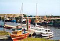
The harbour at Helmsdale
-
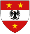
Arms of the former Sutherland County Council
-
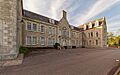
Drummuie, the former headquarters of Sutherland County Council
-
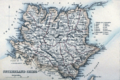
An 1861 map of Sutherland, with its parishes outlined in red
-
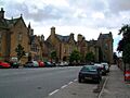
Castle Street in the Royal Burgh of Dornoch
-

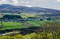
Lairg
-
Tongue
