Suilven facts for kids
Quick facts for kids Suilven |
|
|---|---|
| Sùilebheinn | |

Suilven
|
|
| Highest point | |
| Elevation | 731 m (2,398 ft) |
| Prominence | 496 m (1,627 ft) |
| Listing | Graham, Marilyn |
| Naming | |
| English translation | Pillar mountain |
| Language of name | Old Norse + Scottish Gaelic |
| Geography | |
| OS grid | NC153183 |
| Topo map | OS Landranger 15 |
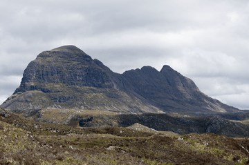
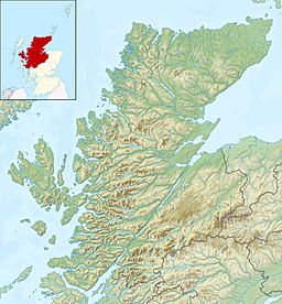
Suilven (Scottish Gaelic: Sùilebheinn) is a famous mountain in Scotland. It stands tall in a wild area called Sutherland, in the west of the country. This area is part of the Inverpolly National Nature Reserve. Suilven rises from a landscape of open moorland, wet bogs, and small lochs (lakes).
Suilven looks like a long, steep-sided ridge, about 2 kilometers (1.2 miles) long. Its highest point is called Caisteal Liath, which means "Grey Castle" in Scottish Gaelic. This peak is at the northwest end of the ridge. There are two other peaks on Suilven:
- Meall Meadhonach ("Middle Round Hill") is in the middle of the ridge and is 723 meters (2,372 feet) high.
- Meall Beag ("Little Round Hill") is at the southeastern end.
Contents
How Suilven Was Formed
Suilven is made of a type of rock called Torridonian sandstone. This sandstone sits on top of much older rocks known as Lewisian gneiss. Over many years, the rocks around Suilven were worn away by ice.
Long ago, a huge sheet of ice covered Suilven and most of Britain. This was during a time called the Ice Age. The moving ice shaped Suilven, making its sides very steep. It also gave the mountain its unique teardrop shape when seen from above.
Who Owns and Manages Suilven?
In 2005, the land that includes Suilven was bought by the local community. This was done with help from the John Muir Trust. The group that now manages the land is called the Assynt Foundation.
Their goal is to create jobs for local people. They also want to protect the natural beauty and history of the area. This helps both the community and future generations. It also makes sure that everyone can enjoy this special place.
Climbing Suilven Mountain
Climbing Suilven is a challenging but rewarding adventure. The most common way to climb it starts near Lochinver, a village to the west of the mountain.
Starting Your Climb
You begin your hike from the end of a public road that goes to Glencanisp Lodge. From there, a path leads across rolling moorland. You will walk towards the steep north side of Suilven. After about 2 kilometers (1.2 miles), you reach a place called Bealach Mòr. This means "Great Pass" in Scottish Gaelic.
Reaching the Summit
The climb up to Bealach Mòr is very steep. The path here has been improved with many large stone steps. Once you reach the bealach, the summit is close by. The top of Suilven is wide and covered in grass. However, it is almost completely surrounded by steep cliffs.
Other Ways to Climb
Another way to climb Suilven starts from Inverkirkaig. This village is about 4 kilometers (2.5 miles) south of Lochinver. This path also leads to Bealach Mòr, and you will pass the beautiful Kirkaig Falls on the way. You can also start your climb from Elphin, which is on the eastern side of the mountain.
All these routes involve a long journey. You will walk about 25 kilometers (15.5 miles) over rough ground. It's a tough hike, but the views from the top are amazing!
See also
 In Spanish: Suilven para niños
 | John T. Biggers |
 | Thomas Blackshear |
 | Mark Bradford |
 | Beverly Buchanan |


