
Handa Island facts for kids
| Gaelic name | Eilean Shannda |
|---|---|
| Norse name | Sandey |
| Meaning of name | sand isle |
| OS grid reference | NC138480 |
| Coordinates | 58°22′48″N 5°11′10″W / 58.380°N 05.186°W |
| Physical geography | |
| Island group | Inner Hebrides/Islands of Sutherland |
| Area | 309 hectares (1+3⁄16 sq mi) |
| Area rank | 87= |
| Highest elevation | Sithean Mòr 123 m (404 ft) |
| Administration | |
| Sovereign state | United Kingdom |
| Country | Scotland |
| Demographics | |
| Population | 0 |
Handa Island, also known simply as Handa, is a beautiful island located in Eddrachillis Bay. You can find it off the west coast of Sutherland, Scotland. This island is about 309 hectares (760 acres) in size. Its highest point, called Sithean Mòr, reaches 123 metres (404 ft) above sea level.
Handa is super important because of its amazing birdlife and special plants. It's protected as a Scottish Wildlife Trust nature reserve. It's also a Site of Special Scientific Interest (SSSI) and a Special Protection Area (SPA). Many cool seabirds live here, like guillemots, great skuas, puffins, and razorbills. Handa is also part of the stunning North-West Sutherland national scenic area. This is one of 40 such special places in Scotland.
You can visit Handa by taking a small ferry from Tarbet on the mainland. Boat trips also go there from Fanagmore. About five thousand people visit the island every year.
Contents
What's in a Name? The Story of Handa
The name "Handa" comes from a mix of old languages: Gaelic and Norse. The Norse people called it Sandey, which means "sand isle" or "sandy island".
Later, in 1654, a map called Atlas of Scotland showed it as "Ellan-Handey". "Eilean" is a Gaelic word that simply means "island". So, the name became a mix of Gaelic and Norse. Over time, "Handey" changed to "Handa". Some people think the modern Gaelic name, Eilean Shannda, means "island at the sandy river".
Exploring Handa's Landscape

Handa Island is made of red sandstone. It's surrounded by tall cliffs where many birds make their homes. In the north, there's a hill with two peaks. The southern and eastern parts of the island are flatter.
The northern and western coasts have cliffs that are about 100-metre-high (330 ft). You can find beaches on the south and east sides. The Sound of Handa is the water that separates the island from the mainland. There are also smaller islands nearby, like Glas-Leac to the south and Eilean an Aigeach to the northeast.
Amazing Animals and Plants of Handa
Handa is famous for its incredible birdlife. You can spot puffins, razorbills, and guillemots here. The island is so important for birds that it's a Special Protection Area (SPA). Six main bird species are protected here: fulmars, great skuas, guillemots, kittiwakes, and razorbills.
Handa has the biggest breeding colonies of razorbills and guillemots in the UK! About 11% of all razorbills and 9% of all guillemots in Britain live here. The arctic skua and kittiwake populations are also very important. Other birds you might see include eider ducks and oystercatchers.
If you visit Boulder Bay on the south coast, you might see seals and otters. The waters around Handa are also home to Dolphins, basking sharks, and different types of whales.
Handa is also special for its plants, especially those that grow near the sea. On the windy cliff tops, you'll find plants that can handle salty air. These include thrift, sea plantain, and Festuca rubra. In areas that are less exposed to the wind, there are grasslands with many different herbs. Here you can find plants like Yorkshire fog, bluebells, and Scots lovage. Heather and crowberry also grow all over the island.
Handa's Past: A Glimpse into History
Handa Island has a long history. Long ago, it was used as a burial place. You can still see the remains of an old chapel in the southeast. This place is remembered in the name Tràigh an Teampaill, which means "Beach of the Temple".
In 1841, Handa had 65 people living on it. But after the potato famine in 1847, everyone moved away to Nova Scotia. This is a bit surprising because the islanders had a varied diet. They ate oats, fish, and seabirds, so they didn't rely only on potatoes. The people on Handa even had their own "parliament," like the one on St Kilda. This parliament met every day. The oldest widow on the island was even called its "Queen"!
The tall rock formation called the Great Stack of Handa was first climbed from the sea on August 1, 1969. The climbers were Graeme Hunter, Hamish MacInnes, and Douglas Lang.
Today, Handa Island is part of the Scourie Estate. It's owned by Dr. Jean Balfour and J.C. Balfour. For 25 years, the Balfours leased Handa to the RSPB. However, they wanted a Scottish group to manage the island. So, the Scottish Wildlife Trust (SWT) took over. During the summer, the SWT manages the island with one warden and a few volunteers.
Images for kids
-
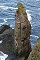
Stacah Geodh Bhrisidh
-
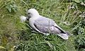
Northern fulmar (Fulmarus glacialis) at Handa Island
-
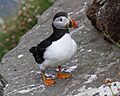
Puffin (Fratercula arctica) at Handa Island
-
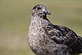
Great skua (Stercorarius skua) at Handa Island
-
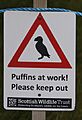
Sign for the breeding birds' protected area
-
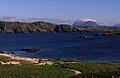
Quinag and Scourie across the Sound of Handa
_bei_Brutf%C3%BCtterung02.jpg)
_auf_Handa_Island.jpg)
_auf_Handa_Island.JPG)


