
Eilean Choraidh facts for kids
| Gaelic name | Eilean Choraidh |
|---|---|
| OS grid reference | NC421580 |
| Coordinates | 58°28′55″N 4°42′32″W / 58.482°N 4.709°W |
| Physical geography | |
| Island group | Outlier |
| Area | 26 ha |
| Highest elevation | 26 m |
| Administration | |
| Sovereign state | United Kingdom |
| Country | Scotland |
| Council area | Highland |
| Demographics | |
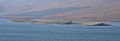
Eilean Choraidh, also known as Horse Island, is a small island in Loch Eriboll. This loch is a sea inlet located in Sutherland, on the northern coast of Scotland. The island is about 26 hectares (which is about 64 acres) in size. Its highest point reaches 26 meters (about 85 feet) above the sea.
Contents
What is Eilean Choraidh?
Eilean Choraidh is a quiet, uninhabited island. It sits peacefully in Loch Eriboll. Even though it's small, it has an interesting history. Today, the island is mainly used for sheep to graze. It's a calm place, far from busy towns.
A Look Back in Time
In the 1800s, Eilean Choraidh was a busy place. People from the Reay estate used to quarry, or dig out, lime from the island. Lime is a useful material. It was then taken to nearby Ard Neakie. There, it was treated in special ovens called lime kilns. After processing, the lime was loaded onto ships. It was then sent to other places for use.
Island Life and War Games
The island has not had many people living on it. Records from 1931 show only one person lived there. Since then, no one has permanently lived on Eilean Choraidh. One reason for this might be its use during World War II.
During the war, the island played a unique role. It was used by the Royal Air Force for target practice. Mosquito bombers used Eilean Choraidh to practice hitting targets. They pretended the island was the German battleship Tirpitz. This was a way for pilots to train without real danger.
Today, you can still see signs of the past. Maps show two ruined buildings on the island. One is in the middle, and another is at the northern end.
Amazing Wildlife and Nature
Eilean Choraidh is home to many wild animals. You might spot otters playing near the water. Grey seals also swim and rest around the island. Sometimes, larger sea animals like cetaceans (which include whales and dolphins) visit the loch.
The waters around Eilean Choraidh are special too. They have beds of a unique type of algae called maerl. Maerl is a red, coralline algae. It is very important for the ocean environment. It provides a home for many sea creatures. Because it is so important, maerl is a protected habitat in the UK. Another interesting sea creature found here is the sea pen, Virgularia mirabilis.
Images for kids
-
Eilean Choraidh.
