
Cromartyshire facts for kids
Quick facts for kids
Cromartyshire
Siorrachd Chromba
|
|
|---|---|
 |
|
| Country | Scotland |
| County town | Cromarty |
| Area | |
| • Total | 370 sq mi (958 km2) |
| Ranked 24th of 34 | |
| Chapman code |
ROC (as part of Ross and Cromarty)
|
Cromartyshire (Scottish Gaelic: Siorrachd Chromba) was a historic county in the Highlands of Scotland. It was made up of the old area around the town of Cromarty and many smaller pieces of land. These smaller pieces, called enclaves and exclaves, were transferred from Ross-shire in the late 1600s.
The biggest part of Cromartyshire, called Coigach, was six times larger than the original area. It was located northwest of Ullapool. In 1890, Cromartyshire joined with Ross-shire to form a new administrative county called Ross and Cromarty. Later, in 1975, this larger county became part of the Highland council area, which is how the region is governed today.
Contents
History of Cromartyshire
How the County Began
The original area of Cromartyshire was a single piece of land on the north side of the Black Isle peninsula. This area was known as a "sheriffdom," which was a bit like a district ruled by a sheriff. For a long time, the role of sheriff was passed down through the Clan Urquhart family.
The county included the parish (a church district) of Cromarty. It also covered most of the nearby parish of Kirkmichael and a small farm in Cullicudden parish.
Changing Borders and New Lands
Cromartyshire first shared a border with Inverness-shire. But in 1504, Ross-shire was created from parts of Inverness-shire, and its borders were set in 1661. In 1662, the Kirkmichael and Cullicudden parishes joined to become the parish of Resolis.
A powerful family, the Mackenzies of Tarbat, bought the lands of Cromarty from the Urquharts in 1682. Sir George Mackenzie, who later became the Earl of Cromartie, wanted to make his scattered lands in Ross-shire part of Cromartyshire. In 1685, he managed to get two laws passed by the Parliament of Scotland to do this.
These new laws added many areas to Cromartyshire, including the barony of Tarbat and other lands near Chanonry and Rosemarkie. This greatly increased the size of Cromartyshire, making it about fifteen times larger than it was before!
Cromartyshire in Parliament
Cromartyshire was the smallest area to send representatives to the Parliament of Scotland. Only a few landowners could vote for its two representatives in 1703.
After Scotland and England joined to form Great Britain in 1707, Cromartyshire shared a Member of Parliament (MP) with Nairnshire. This meant they took turns sending one MP to the Parliament in Westminster.
Joining Forces with Ross-shire
Even though Cromartyshire had many separate pieces of land, some of these "exclaves" were often managed as if they were part of Ross-shire. For example, after 1747, Ross and Cromarty shared the same sheriff.
Official reports also started treating them as one. The 1801 census listed them separately, but by 1811, they were listed together because it was too hard to keep them apart. Roads, police, and taxes were also managed together over time.
Finally, in 1889, a new law called the Local Government (Scotland) Act 1889 officially united Ross and Cromarty. They became one county for all purposes, known as Ross and Cromarty. This new county also took in a few small parts from other nearby counties.
Geography of Cromartyshire
It's tricky to describe the geography of Cromartyshire because it was made up of so many separate parts.
Original Area and Eastern Lands
The original part of the county was on the Black Isle peninsula, next to the Cromarty Firth. Across the firth was the Tarbat peninsula, and several parts of this area, including Tarbat Ness, also belonged to Cromartyshire.
Many of the added pieces of land were in Easter Ross, located east of the main part of the county. These included areas like Portmahomack and Kilmuir.
Western and Inland Areas
To the west, Cromartyshire included various sections around Little Loch Broom. The largest single part of the county was the Coigach peninsula, which included the town of Ullapool. This western area also had many small islands in Enard Bay and the Summer Isles.
The inland sections of Cromartyshire were often mountainous, remote, and not many people lived there. These areas contained many lochs (lakes), such as Fionn Loch and Loch Lurgainn.

Settlements in Cromartyshire
Here are some of the towns and villages that were part of Cromartyshire:
- Achiltibuie
- Altandhu
- Badenscallie
- Cromarty (the county town)
- Dundonnel
- Inver
- Jemimaville
- Kildary
- Milton
- Polbain
- Polglass
- Portmahomack
- Rieff
- Strathpeffer
- Ullapool
Images for kids
-
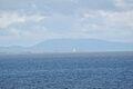
Tarbat Ness seen from across the Moray Firth.
-
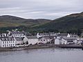
The town of Ullapool, a key settlement in the Coigach area of Cromartyshire.


