
Moray Firth facts for kids
Quick facts for kids Moray Firth |
|
|---|---|

Moray Firth
Location in Scotland
|
|

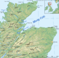
Map of the Firth
|
|
| Location | Scotland, United Kingdom |
| Coordinates | 57°50′N 03°35′W / 57.833°N 3.583°W |
| Official name: Inner Moray Firth | |
| Designated: | 22 July 1999 |
| Reference #: | 1002 |
The Moray Firth (Scottish Gaelic: An Cuan Moireach, Linne Mhoireibh or Caolas Mhoireibh) is a large, triangular bay (or "firth") on the coast of Scotland. It's part of the North Sea and stretches from Inverness in the west to Duncansby Head in the north and Fraserburgh in the east. It's the biggest firth in Scotland, with over 800 kilometers (about 500 miles) of coastline, much of it made of cliffs. Three different areas of Scotland touch the Moray Firth: Highland, Moray, and Aberdeenshire.
Contents
What's in a Name?
The name Moray Firth comes from an old kingdom called Moray that existed here in the 10th century. The name Moray itself might come from the sea of the firth. Some people think local names like Murar or Morar come from the Gaelic word Muir, which means "sea." Other ideas suggest it comes from old Celtic words like Mur (sea) and Tav (side), which together could mean "sea-side."
Exploring the Geography


Many rivers flow into the Moray Firth. Some of the main ones include the River Ness, the River Findhorn, and the River Spey. There are also smaller bays and firths that connect to the Moray Firth, such as the Cromarty Firth and the Dornoch Firth. The Pentland Firth also meets the Moray Firth at its northern edge.
Inner and Outer Moray Firth
The Moray Firth can be thought of as two main parts. The Inner Moray Firth is closer to land and was once known as the Firth of Inverness. It stretches from the Beauly Firth in the west to Chanonry Point in the east. The Outer Moray Firth is more open and connects directly to the wider North Sea.
Seeing Far and Wide
On a clear day, you can see for very long distances across the Moray Firth. For example, from Buckie, you might even spot Wick, which is over 50 miles (80 kilometers) away in the far north of Scotland! From Lossiemouth, you can see the hills of Caithness, including Morven and Scaraben. If you're in Nairn, you might even see the two red bands on the Tarbat Ness Lighthouse with binoculars, even though it's about 20 miles (32 kilometers) away.
How the Moray Firth Was Formed
The Moray Firth was created by powerful forces deep within the Earth, linked to something called the Helmsdale Fault. This means its shape is due to the movement of Earth's plates.
Long ago, during the Ice Age, the entire area of the Moray Firth was covered by a huge glacier (a giant sheet of ice). Even today, the inner part of the firth and its smaller inlets, like the Cromarty Firth and Dornoch Firth, are actually fjords. Fjords are deep, narrow inlets of the sea that were carved out by glaciers.
Although the Moray Firth has tides that rise and fall about three meters (ten feet), not all the rivers flowing into it have wide, open river mouths (called estuaries). Over time, lots of sand and mud from the nearby mountains have built up, forming spits of land around some river mouths. This has made the fjords narrower where rivers like the River Ness and River Carron enter.
Wildlife and Economy
The Moray Firth is a very special place for seeing amazing marine animals like dolphins and whales. The most common types you might spot are the bottlenose dolphin and the harbour porpoise. Sometimes, you might even see common dolphins or minke whales.
Dolphin Watching Hotspots
One of the best places to watch dolphins is at Chanonry Point in the inner Moray Firth. You can often see them leaping and playing there! There are also visitor centers run by the Whale and Dolphin Conservation Society at Spey Bay and North Kessock, where you can learn more about these creatures and often see them in the wild. Near Fort George Point, there's a Dolphin Research Centre where scientists study dolphins.
Resources and Industries
Besides its incredible wildlife, the Moray Firth is also important for its natural resources. There are oil fields here, like the Beatrice oil field, which is one of the closest North Sea oil fields. This area is also home to the Beatrice Wind Farm, which uses wind power to create electricity. The fishing industry here mainly catches scallops and Norway lobsters.
Protecting the Environment
To protect its unique wildlife and habitats, the Inner Moray Firth has been named a special protection area. It also contains a special area of conservation (SAC), which is one of the largest marine protected areas in Europe. This SAC helps protect the inner waters of the Moray Firth, from a line between Lossiemouth (on the south coast) and Helmsdale (on the north coast) westwards.
Images for kids
-
Map of the Firth
See also
 In Spanish: Fiordo Moray para niños
