Pentland Firth facts for kids
Quick facts for kids Pentland Firth |
|
|---|---|

|
|
| Location | Scotland, UK |
| OS grid | ND355815 |
| Coordinates | 58°42′58″N 3°06′54″W / 58.716°N 3.115°W |
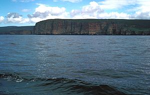
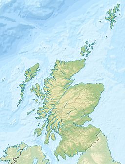
The Pentland Firth (which means the Orcadian Strait in Scottish Gaelic) is a narrow stretch of water. It separates the Orkney Islands from Caithness in the north of Scotland. Even though it is called a "firth," it is actually a strait. A strait is a narrow passage of water connecting two larger areas of water.
Contents
What's in a Name?
The name "Pentland Firth" likely comes from an old language called Old Norse. In Old Norse, "Petlandsfjörð" meant "the fjord of Pictland." The Picts were an ancient people who lived in Scotland. This name has nothing to do with the Pentland Hills near Edinburgh.
Before the Norse people came to Orkney, this strait was known as the "Sea of Orcs." This name referred to the Pictish tribe who lived on the Orkney Islands. The Picts were very skilled sailors. Sometimes, this name even described the sea routes along the entire west coast of Scotland.
Where is the Pentland Firth?
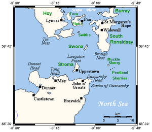
On the Caithness side, which is the southern side, the Firth stretches from Dunnet Head in the west. It goes all the way to Duncansby Head in the east. On the Orkney side, which is the northern side, it extends from Tor Ness on Hoy in the west. It reaches Old Head on South Ronaldsay in the east.
In the middle of the Firth, there are two important islands. These are Stroma and Swona. A small group of islands called the Pentland Skerries are located in the east. The larger islands of Hoy and South Ronaldsay are part of the Orkney Islands. They form the northern border of the Firth.
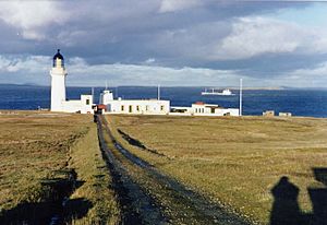
The most northern point of mainland Great Britain is Easter Head, on the headland of Dunnet Head. Many famous places are also found on the Caithness side. These include John o' Groats, Mey (where the Castle of Mey is), and smaller villages. The town of Thurso and Scrabster Harbour are also on the western edge of the Firth.
Crossing the Water
In the western part of the Firth, a ferry service runs from Scrabster to Stromness. This service is operated by NorthLink Ferries. It is the oldest continuous ferry route across the Firth, starting in 1856. The ferry MV Hamnavoe uses this route.
Historically, the Gills Bay area was the main starting point from the mainland. People would travel to the islands of Stroma, Swona, and Orkney itself. Today, Pentland Ferries operates a route from Gills Bay to St Margaret's Hope on South Ronaldsay.
At the eastern end, John o' Groats Ferries sail to Burwick. Burwick is also on South Ronaldsay. This is a smaller passenger ferry that runs only during the summer months.
There was also an idea to build a tunnel connecting the islands to the mainland. This tunnel would have been about 10 kilometers (6 miles) long. Studies in 2005 suggested it would cost around £100 million. However, no further progress has been made on this tunnel project since 2012.
The first person to swim across the Pentland Firth was Coleen Blair in 2011. Since then, others have also swum across. These include Andrea Gellan (who made the fastest swim in 2011), Mark Cameron (2018), and Alison Lievesley (2020).
Powerful Tidal Races
The Pentland Firth is famous for its incredibly strong tides. These are some of the fastest tides in the world. Speeds of 30 kilometers per hour (19 mph) have been recorded near the Pentland Skerries. The power of these tides creates special water features called overfalls and tidal races. These can appear at different times depending on the tide. When strong tides combine with stormy winds, the sea can become extremely rough. This has led to accidents, like the sinking of the cargo ship MV Cemfjord in 2015, which caused the death of eight crew members.
Some of the main tidal races are:
- The Merry Men of Mey: This race forms off St John’s point when the tide flows west. It stretches across the Firth to Tor Ness. The roughest part is over a sandy area about 5.5 kilometers (3.4 miles) west of Stroma. The waves from this race can create a natural barrier, making the water calmer behind it. Tides in this area can go faster than 19 kilometers per hour (12 mph).
- The Swelkie: This race is at the north end of Stroma, near Swelkie Point. It can be very violent. A whirlpool here, also called "The Swelkie," is part of a Viking legend. The legend says a sea-witch turns mill wheels here to grind salt, keeping the seas salty. The name "Swelkie" comes from an Old Norse word meaning "the Swallower."
- The Duncansby Race: This race forms off Ness of Duncansby when the tide starts flowing southeast. It changes direction as the tide strengthens. It can be very dangerous, especially when strong winds blow against the tide.
Other races also form at both the north and south ends of Stroma and Swona. Between these fast-moving races, there are calmer areas called eddies. These races are easy to see with their overfalls and whirlpools. Even large ships can be pushed off course when crossing from a calm eddy into a fast-moving race.
Harnessing Tidal Power
The strong currents in the Pentland Firth, which can reach 5 meters per second (11 mph), make it one of the best places in the world for tidal power. Tidal power uses the movement of tides to create electricity. This has become an important topic for Scotland.
In 2006, the SNP suggested the Firth could produce a huge amount of electricity. First Minister Alex Salmond even called the Pentland Firth "the Saudi Arabia of tidal power." He believed it could produce 20 gigawatts or more. However, a study in 2013 suggested a more realistic potential of about 1 gigawatt. Still, this is a significant amount of clean energy.
In 2008, a company called Atlantis Resources Corporation (ARC) looked into building a data center near the Castle of Mey. This center would be powered by a tidal energy project in the Firth. Later, in 2010, a group called MeyGen (which includes ARC) received permission to build a large tidal power project.
MeyGen planned a project that could eventually generate 398 megawatts of power. In 2019, MeyGen completed the longest continuous run of tidal electricity generation ever. They produced 25 gigawatt-hours of electricity. This was enough to power almost 4,000 homes!
Amazing Marine Wildlife
The Pentland Firth is home to many different kinds of marine animals.
Seals
You can see seals all year round in the Firth. They often rest on rocks when the tide is falling. This way, they don't have to move as the water rises. Large groups of seals can be found at the north and south ends of Stroma. They are also seen on Swona.
There are two main types of seals here. The common seal comes in different colors with spots. Their pups are born in May, June, and July and can swim right away. The grey seal is more common in this area. They also come in various colors and live in colonies. Grey seal pups are born white from October to January. These pups cannot swim until they lose their white coat.
Porpoises and Dolphins
Porpoises can be seen all year in the Firth, though they prefer shallower water. They grow to about 1.5 meters (5 feet) long. They are black with a small, triangular fin that you can see when they surface. They have a small, round body and a blunt head. You usually see them alone or in small groups. In autumn, many groups can be seen in Gills Bay.
Dolphins are not as common but are seen sometimes. Many different types visit the Firth. They are larger than porpoises, growing to 2–3 meters (6.5–10 feet). They are black, with a curved fin and a distinct beak. Dolphins often swim alongside boats and jump out of the water. They usually swim together in a more organized way than porpoises.
Whales
Killer whales are mostly seen from May to July, but can appear at any time. They usually swim in groups called pods, with up to twelve individuals led by an older female. Males can grow up to 9 meters (30 feet) long. They are easy to spot because of their size, fin, and markings. Males have a very tall, triangular fin. Females and young whales have a smaller, curved fin.
Minke whales are often seen in June and sometimes until October. They usually feed in the strong currents of the tidal races. They are typically seen alone or in pairs. Minke whales grow to 7-8.5 meters (23-28 feet) long. They are black with a white band on their flippers and a slender, pointed head.
Sharks and Turtles
Basking sharks are rare but are being seen more often from May to August. These are fish, not mammals. They spend most of their time swimming near the surface, filtering food from the water. You can often see their dorsal fin moving steadily through the water. They are usually about 8 meters (26 feet) long and are greyish-brown to bluish-black.
Turtles are very rarely seen here. However, they are sometimes caught in fishing nets. The leatherback turtle is the most common species found in UK waters. It grows to about 2.9 meters (9.5 feet) long. It has a black shell with white spots. Leatherback turtles travel to UK waters in the summer to eat jellyfish.
 | Jessica Watkins |
 | Robert Henry Lawrence Jr. |
 | Mae Jemison |
 | Sian Proctor |
 | Guion Bluford |


