
Orkney Islands facts for kids
| Gaelic name | Arcaibh |
|---|---|
| Norse name | Orkneyjar |
| Meaning of name | "Ork" possibly originally from a Pictish tribal name meaning ‘young pig’. |
 Flag
 Coat of arms
|
|
| Coordinates | 59°0′N 3°2′W / 59.000°N 3.033°W |
| Physical geography | |
| Island group | Northern Isles |
| Area | 990 km2 (380 sq mi) |
| Administration | |
| Sovereign state | United Kingdom |
| Country | Scotland |
| Council area | Orkney Islands Council |
| Demographics | |
| Population | 22,100 (2017) |
| Population density | 20/km2 (52/sq mi) |
| Largest settlement | Kirkwall |
Orkney, also known as the Orkney Islands, is a group of islands in Scotland. It is part of the Northern Isles and sits off the north coast of Great Britain. Orkney is about 10 miles (16 km) north of Caithness. It has around 70 islands, and 20 of them have people living on them.
The biggest island is called Mainland. It covers 523 square kilometres (202 sq mi) and is the sixth-largest Scottish island. The main town and government center is Kirkwall. Orkney is one of Scotland's 32 local council areas. It is also a historic county.
People have lived on Orkney for at least 8,500 years. Early tribes like the Mesolithic and Neolithic people lived here. Later, the Picts made it their home. In 875, Norway took control of Orkney. The Norsemen settled there. In 1472, Orkney became part of Scotland. This happened when Norway couldn't pay a dowry for James III of Scotland's bride.
Most of the islands are in two groups: the North and South Isles. They are all made of Old Red Sandstone. The weather is mild, and the soil is very good for farming. Farming is the most important part of the economy. Orkney also uses a lot of wind and sea energy. It produces more electricity than it needs from renewable sources.
The local people are called Orcadians. They have a special dialect of the Scots language. They also have many old stories and traditions. Orkney has some of the oldest and best-kept Neolithic sites in Europe. The "Heart of Neolithic Orkney" is a UNESCO World Heritage Site. The islands are also home to lots of sea and bird wildlife.
Contents
Orkney's Past: A Journey Through Time

Early Settlers: Stone and Bronze Ages
People first lived in Orkney around 6820–6660 BC. This was shown by a burnt hazelnut shell found in Tankerness. The first known permanent home was at Knap of Howar. This Neolithic farmstead on Papa Westray dates back to 3500 BC.
The village of Skara Brae is Europe's best-preserved Neolithic settlement. People lived there from about 3100 BC. Other old sites include the Stones of Stenness, the Maeshowe passage grave, and the Ring of Brodgar. Many Neolithic villages were left around 2500 BC. This might have been due to climate changes.
During the Bronze Age, fewer large stone buildings were made. Metalworking slowly came to Britain from Europe. There are not many Bronze Age sites in Orkney. But there is the impressive Plumcake Mound near the Ring of Brodgar.
Iron Age Forts and Roman Visits

Around 700 BC, people built roundhouses in Orkney. The most impressive Iron Age buildings are the ruins of round towers called "brochs". Examples include the Broch of Burroughston and Broch of Gurness. We are still learning about how these buildings were used. Other structures include underground storehouses.
When the Romans invaded Britain, the "King of Orkney" was one of 11 leaders. He is said to have surrendered to Emperor Claudius in AD 43. The Romans did not conquer Orkney directly. Their influence was mainly through trade.
By the late Iron Age, Orkney was part of the Pictish kingdom. The Picts likely lived well from the fertile land and rich seas. Later, Celtic missionaries came to the islands. But then, the Norse people arrived. They slowly took over from the Picts starting in the late 700s.
Viking Rule and Christianisation

Many Norwegian settlers came to Orkney and Shetland in the late 700s and early 800s. Vikings used the islands as a base for their raids. In response, Norwegian king Harald Fairhair took control of Orkney and Shetland in 875. He gave Orkney to Rognvald Eysteinsson as an earldom. Rognvald then gave it to his brother Sigurd the Mighty.
After Sigurd, Torf-Einarr started a family line that ruled Orkney for centuries. His son, Thorfinn Skull-splitter, followed him. During this time, the deposed Norwegian King Eric Bloodaxe often used Orkney as a raiding base.

Orkney was originally a pagan culture. In 995, Olaf Tryggvasson made the islands Christian. He told the jarl Sigurd the Stout to be baptized. If Sigurd refused, Olaf would kill him and destroy the islands. So, Sigurd agreed, and Orkney became Christian. It got its own bishop in the early 1000s.
Thorfinn the Mighty was Sigurd's son. He ruled Orkney in the early 1000s. He also controlled a small sea empire. Thorfinn died around 1065. His sons, Paul and Erlend, took over. They fought at the Battle of Stamford Bridge in 1066.
Later, Magnus Erlendsson was killed by his cousin. This led to the building of St Magnus Cathedral in Kirkwall. It is still a very important building today.

From about 1100, the Norse jarls had to be loyal to both Norway and Scotland. In 1231, the Norse line of earls ended. The earldom then went to the Sinclair family in 1379.
You can still see signs of the Viking presence today. These include the settlement at the Brough of Birsay. Many place names are Norse. There are also runic writings at Maeshowe.
Becoming Part of Scotland

In 1468, Christian I of Denmark used Orkney as a promise. He needed to pay the dowry for his daughter Margaret. She was going to marry James III of Scotland. But the money was never paid. So, Orkney became part of Scotland in 1472.
After this, more Scottish business people came to Orkney. They helped create a diverse community. This included farmers, fishermen, and merchants. They called themselves comunitas Orcadie. They worked hard to protect their rights.
In the 1600s, Orkney people made up most of the workers for the Hudson's Bay Company in Canada. Their skills with boats and their tough nature made them good for the Canadian north.
Modern Orkney: Wars and Prosperity

Orkney was home to a Royal Navy base at Scapa Flow. This base was very important in World War I and World War II. After World War I, the German fleet was sent to Scapa Flow. The German sailors sank their own ships there. Most were brought up, but some wrecks are still there. Divers like to explore them.
In World War II, a German submarine sank a British battleship in Scapa Flow. Because of this, barriers were built. These closed off most of the sea entrances. They also created roads between some islands. Italian prisoners of war built these causeways. They also built the beautiful Italian Chapel.
After the war, the navy base closed in 1957. The number of people living in Orkney went down for a while. But in recent years, it has grown again. Life in Orkney is now focused on growing prosperity. Orkney was named the best place to live in Scotland in 2013 and 2014. In 2019, it was called the best place to live in the UK.
Where is Orkney? Its Geography


Orkney is separated from mainland Scotland by the Pentland Firth. This is a 10 km (6 mi) wide stretch of water. It lies between South Ronaldsay and Caithness. Orkney measures 80 km (50 mi) from northeast to southwest. It is 47 km (29 mi) from east to west. The total area is 975 square kilometres (376 sq mi).
The Shetland Islands are further out. They are separated from Orkney by the Fair Isle Channel.
Most of Orkney's islands are low and flat. But there are some steep sandstone hills on Hoy, Mainland, and Rousay. Some western coasts have rugged cliffs. Nearly all islands have lochs (lakes). The rivers are just small streams. The coastlines have many inlets. The islands are separated by narrow sea passages called "sounds" or "firths".
The tidal currents around the islands are very strong. They often create whirlpools. Orkney is known for having very few trees. This is partly because of the strong winds.
Orkney's Islands: North and South
The Mainland: Orkney's Heart

The Mainland is the largest island in Orkney. Both of Orkney's main towns, Kirkwall and Stromness, are here. The Mainland is the center of Orkney's transport system. It has ferry and air links to other islands and the outside world. Most of Orkney's people (75%) live here. It also has a lot of fertile farmland.
The Mainland is divided into East and West Mainland. This depends on whether they are east or west of Kirkwall. Most of the land is west of Kirkwall.
The island is mostly low-lying. But it has coastal cliffs in the north and west. There are two large lochs: the Loch of Harray and the Loch of Stenness. The Mainland has many old Neolithic, Pictish, and Viking sites. Four main Neolithic sites are part of the Heart of Neolithic Orkney World Heritage Site.
Other islands are grouped as north or south of the Mainland. The remote islets of Sule Skerry and Sule Stack are exceptions. They are far to the west but are part of Orkney. In island names, "a" or "ay" comes from the Norse word ey, meaning "island". Small islands called "holms" are very tiny.
The North Isles: Farming and Fishing

The northern group of islands is the largest. It has many medium-sized islands. Ferries and air services connect them to the Mainland. Farming, fishing, and tourism are the main ways people earn money here.
The most northern island is North Ronaldsay. It is 4 km (2 mi) from its closest neighbor, Sanday. To the west is Westray, with about 550 people. It is linked to Papa Westray, also called "Papay". Eday is in the middle of the North Isles. Its main industries have been digging for peat and quarrying limestone.
Rousay, Egilsay, and Gairsay are north of the west Mainland. Rousay is famous for its old monuments. These include the Quoyness chambered cairn. Egilsay has the ruins of Orkney's only round-towered church. Wyre has the site of Cubbie Roo's castle.
Stronsay and Papa Stronsay are further east. Auskerry is south of Stronsay and has only five people. Shapinsay and its Balfour Castle are close to Kirkwall.
Many small, uninhabited islands are also in the North Isles.

The South Isles: Around Scapa Flow
The southern islands are around Scapa Flow. Hoy is the second largest Orkney island. Ward Hill on Hoy is the highest point in Orkney. The Old Man of Hoy is a famous sea stack.
Burray is east of Scapa Flow. It is connected by a road to South Ronaldsay. South Ronaldsay hosts the Festival of the Horse. It also has the Neolithic Tomb of the Eagles. Graemsay and Flotta have ferry links to the Mainland and Hoy. Flotta is known for its large oil terminal.
South Walls has a 19th-century Martello tower. It is connected to Hoy by the Ayre. South Ronaldsay, Burray, Glimps Holm, and Lamb Holm are connected to the Mainland by the Churchill Barriers.
Many uninhabited islands are also in the South Isles.
Orkney's Rocks: Geology

Most of Orkney's surface rock is Old Red Sandstone. This rock formed during the Middle Devonian period. This sandstone sits on top of older metamorphic rocks. You can see these rocks on the Mainland. They are made of grey gneiss and granite.
The Old Red Sandstone is divided into three main groups. The lower parts are mostly from the Eifelian age. They are made of flagstones that formed in a large lake. The later Rousay flagstone formation is found across many islands.
The Old Man of Hoy is made from the highest Eday group sandstone. This rock can be up to 800 meters (2,600 ft) thick.

Orkney's rocks have many faults. These are cracks where the rock has moved. There is also a strong fold in the rock on Eday and Shapinsay.
Middle Devonian volcanic rocks are found on western Hoy. They are also on Deerness and Shapinsay. Ice has also shaped the islands. You can see this from glacial scratches on rocks. There are also chalk and flint rocks that were moved by glaciers.
Orkney's Weather: Climate
Orkney has a cool, mild climate. This is surprising for how far north it is. The Gulf Stream makes it warmer. The average yearly temperature is 8 °C (46 °F). In winter, it's about 4 °C (39 °F). In summer, it's around 12 °C (54 °F).
The average yearly rainfall is between 850 millimetres (33 in) and 940 millimetres (37 in). Winds are a big part of the climate. Even in summer, there are almost always breezes. In winter, strong winds are common. There are about 52 hours of gales each year.
One interesting thing for visitors is the "nightless" summers. On the longest day, the sun rises at 04:00 and sets at 22:29. It never gets completely dark. This long twilight is called the "simmer dim". Winter nights are long. On the shortest day, the sun rises at 09:05 and sets at 15:16. Sometimes, the aurora borealis (Northern Lights) can be seen then.
Orkney's Economy: How People Live
Orkney's soil is very fertile. Most of the land is used for farms. Agriculture is the most important part of the economy. It provides jobs for a quarter of the workers. Over 90% of farm land is used for grazing sheep and cattle. Only about 4% is used for growing cereals.
Fishing is less important now. But it still provides jobs for many people. The modern fishing industry focuses on herring, white fish, lobsters, crabs, and salmon fish farming.
Today, Orkney exports beef, cheese, whisky, beer, and fish. In recent years, tourism has grown. Other growing areas include food and drink making, jewelry, and crafts. Construction and oil transport are also important. The Flotta oil terminal plays a big role. Shops provide 17.5% of jobs. Public services also employ a third of the workers.
Powering Orkney: Renewable Energy

Orkney has a lot of wind and sea energy. Renewable energy has become very important. Orkney is connected to the mainland. But it produces over 100% of its electricity from renewable sources. This mostly comes from wind turbines across the islands.
Getting Around: Transport
Air Travel
Highland and Islands Airports runs Kirkwall Airport. Loganair flies from Kirkwall to Scottish mainland cities. These include Aberdeen, Edinburgh, Glasgow, and Inverness. They also fly to Sumburgh Airport in Shetland.
Within Orkney, the council runs airfields on most larger islands. These include Stronsay, Eday, and North Ronaldsay. The shortest scheduled air service in the world is here. It flies between Westray and Papa Westray. It is scheduled for two minutes but can be less than one minute.
Ferry Travel

Ferries connect Orkney to Scotland and Shetland. They also link the different islands of Orkney.
Ferry services from Orkney to the Scottish mainland and Shetland include:
- Gills Bay to St Margaret's Hope (Pentland Ferries)
- John o' Groats to Burwick on South Ronaldsay (seasonal passenger service)
- Lerwick to Kirkwall (NorthLink Ferries)
- Aberdeen to Kirkwall (NorthLink Ferries)
- Scrabster Harbour, Thurso to Stromness (NorthLink Ferries)
Inter-island ferries connect all inhabited islands to Orkney Mainland. Orkney Ferries runs these services. This company is owned by the Orkney Islands Council.
Festivals: Fun Events
Orkney hosts several international festivals. These include the Orkney International Science Festival in September. There is also a folk festival in May. The St Magnus International Arts Festival is held in June.
Language, Stories, and People

When history was first written down, the Picts lived on the islands. Their language was Brythonic. After the Norse took over, most place names became Norse. The Norse language changed into Norn. This language was spoken until the late 1700s.
Then, the Orcadian dialect of Insular Scots took over. This dialect is not used as much now. This is because of TV, schools, and new people moving in. But some writers and radio hosts are trying to bring it back. Many Norse words are still used. The most common Orcadian word visitors hear is peedie, meaning small. It might come from the French word petit.
Orkney has many old stories. Many are about trows. These are like trolls and come from the islands' Scandinavian past. In the past, marriage ceremonies happened at the Odin Stone. This stone was part of the Stones of Stenness.
King Lot in some Arthurian legends is the ruler of Orkney. His sons, Gawaine, Agravaine, Gareth, and Gaheris, are important characters.
Famous writers from modern Orkney include the poet Edwin Muir. Also, the poet and novelist George Mackay Brown. And the novelist Eric Linklater.
Orcadians: The People of Orkney
An Orcadian is someone born in Orkney. They have a strong sense of who they are. Orkney became part of Scotland over 500 years ago. But some Orcadians see themselves as Orcadians first, and Scots second. However, in the 2011 census, most people in Orkney said they felt Scottish.
People in Orkney often call mainland Scotland "Scotland". They call Mainland, Orkney "the mainland". Orkney has its own unique culture. Traditions like tartan, clans, and bagpipes are not native to the islands. But there are some tartans with Orkney connections. There are also pipe bands in Orkney.
Native Orcadians call people who move to the islands "ferry loupers". This means "ferry jumpers" in the Scots language. This term has been used for almost 200 years.
Nature and Wildlife

Orkney has a lot of wildlife. You can see many grey and common seals. There are also many seabirds. These include puffins, kittiwakes, and tysties. Ravens and bonxies are also common. Whales, dolphins, and otters are seen around the coasts.
Inland, there is the Orkney vole. This is a special type of common vole. It was brought to Orkney by early humans. It is found only here. There are five different kinds of Orkney vole. They live on Sanday, Westray, Rousay, South Ronaldsay, and the Mainland. This is amazing because this species is not found on mainland Britain.
The coastline is known for its colorful flowers. These include sea aster, sea squill, and sea thrift. The Scottish primrose is found only on the coasts of Orkney and nearby areas. Trees are generally rare. But a small forest called Happy Valley was created. It has 700 trees and lush gardens.
The North Ronaldsay sheep is a unique farm animal. It mostly eats seaweed. This is because they are kept on the shore for most of the year. This helps save the limited grazing land inland. Walruses used to live on the island until the mid-1500s.
The Orkney char (Salvelinus inframundus) used to live in Heldale Water on Hoy. It has not been seen since 1908.
Stoats were brought to Orkney just before 2015. They are natural predators of voles. They might be harming the native bird populations.
Images for kids
-
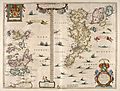
Blaeu's 1654 map of Orkney and Shetland.
-
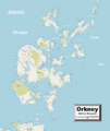
Detailed map of Orkney.
-
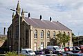
Council Offices on School Place, Kirkwall.


.jpg)
See also
 In Spanish: Orcadas para niños
