
Willem Blaeu facts for kids
Quick facts for kids
Willem Janszoon Blaeu
|
|
|---|---|

Willem Janszoon Blaeu by Jeremias Falck
|
|
| Born | 1571 |
| Died | 21 October 1638 (aged 66–67) |
| Other names | Willem Jansz. Blaeu |
| Occupation | Cartographer, atlas maker, publisher |
Willem Janszoon Blaeu (Dutch pronunciation: [ˈʋɪləm ˈjɑnsoːm ˈblʌu]; 1571 – 21 October 1638), also known as Willem Jansz. Blaeu, was a famous Dutch mapmaker, atlas creator, and publisher. He worked with his son, Johannes Blaeu. Willem is seen as one of the most important people in Dutch mapmaking. This was during its "golden age" in the 16th and 17th centuries.
Contents
Willem Blaeu's Life Story
Blaeu was born in either Uitgeest or Alkmaar. His father was a successful fish seller. Willem was expected to follow his dad's business. But he was more interested in mathematics and astronomy.
Learning and Discoveries
Between 1594 and 1596, Willem studied with Tycho Brahe. Brahe was a famous Danish astronomer. During this time, Willem learned to make tools and globes. His son, Joan Blaeu, was born in 1596. Joan also became a well-known mapmaker. In 1600, Willem found the second variable star ever. A variable star is one that changes how bright it looks. This star is now called P Cygni.
Starting His Business
When he returned to Holland, Willem started making maps of countries and globes of the world. He had his own printing shop. This meant he could regularly print maps in books called atlases. Some of his maps appeared in the Atlas Novus, published in 1635.
In 1633, he became the official mapmaker for the Dutch East India Company. This was a very big Dutch trading company. Willem also published books by many important thinkers. These included Descartes and Hugo Grotius. He died in Amsterdam.
Family Business Continues
Willem had two sons, Johannes and Cornelis Blaeu. They continued their father's mapmaking and publishing business. This happened after Willem's death in 1638. You can still buy prints of their family's work today. Original maps are very rare and valuable collector items.

_UTA.jpg)
Blaeu's Maps in Art
Blaeu's maps were so famous that they appeared in paintings. The Dutch painter Johannes Vermeer often showed them in his art. Vermeer lived from 1632 to 1675. He is a very respected artist among map historians.
Many of Vermeer's paintings show maps hanging on walls. Others show globes on tables or cabinets. Vermeer painted these maps with so much detail. It is often possible to tell exactly which map he painted.
Vermeer especially liked a map of Holland and West Friesland. This map was made by Willem Blaeu and Balthasar Florisz van Berckenrode. Vermeer showed it as a wall decoration in three of his paintings. One painting is Officer and Laughing Girl (around 1658). It shows a soldier talking to a smiling girl. Bright sunlight shines on the girl and the large map on the wall. Vermeer's painting shows the map so clearly. You can see it is Blaeu's 1621 map of Holland and West Friesland.
Willem Blaeu's Lasting Impact

His maps made up most of the Atlas Maior. This atlas became a very popular item for collectors in Amsterdam.
Important Works by Willem Blaeu
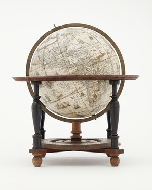
- Aardglobe (1599) - A globe of the Earth.
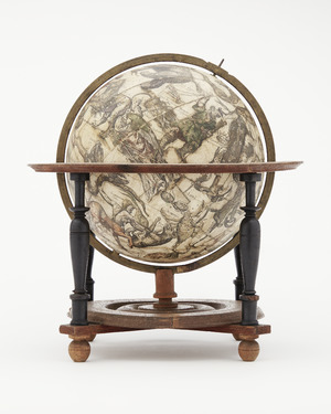
- Hemelglobe (1603) - A globe of the heavens.
- Nieuw Graetboeck (1605) - A book about measurements.
- Nywe Paskaerte (1606) - A new sea chart.
- 't Licht der zeevaert (1608) - The Light of Navigation.
- Spieghel der Schrijfkonste (1609) - Mirror of the Art of Writing.
- "Nova et Accurata Totius Hollandiae Westfriesiaeq. Topographia, Descriptore Balthazaro Florentio a Berke[n]rode Batavo" - A new and accurate map of Holland and West Friesland.
- Tafelen van de declinatie der Sonne (1623) - Tables of the Sun's declination.
- Tafelen van de breedte van de opgang der Sonne - Tables of the Sun's rising latitude.
- Zeespiegel, inhoudende een korte onderwysinghe inde konst der zeevaert, en beschryvinghe der seen en kusten van de oostersche, noordsche, en westersche schipvaert (1624) - Sea Mirror, with instructions for navigation and descriptions of seas and coasts.
- Pascaarte van alle de zeecusten van Europa (1625) - Sea chart of all European coasts.
- Tweevoudigh onderwijs van de Hemelsche en Aerdsche globen; het een na de meyning van Ptolemævs met een vasten aerdkloot; het ander na de natuerlijcke stelling van N. Copernicus met een loopenden aerdkloot. - Double instruction on celestial and terrestrial globes.
- Atlantis Appendix (1630) - An addition to his atlas.
- Appendix Theatri ... et Atlantis ... (1631) - Another atlas addition.
- Atlas (1634) - An atlas.
- Novus Atlas (1635) - New Atlas.
- Theatrum Orbis Terrarum (1635) - Theater of the World.
- Toonneel des Aerdrycks (1635) - Stage of the Earth.
- Le Theatre du Monde (1635) - The Theater of the World (French).
- Theatre du monde ou Nouvel Atlas (1638) - Theater of the World or New Atlas (French).
See also
 In Spanish: Willem Blaeu para niños
- Hessel Gerritsz
- Cartography in the Dutch Republic
- History of cartography
Literature
- P. J. H. Baudet: Leven en werken van Willem Jansz. Blaeu, Utrecht 1871.
- Johannes Keuning and Marijke Donkersloot-de Vrij (Edited): Willem Jansz. Blaeu: a biography and history of his work as cartographer and publisher, Amsterdam 1973. ISBN: 90-221-1253-5
