
Lerwick facts for kids
Quick facts for kids Lerwick |
|
|---|---|
 Lodberries, Lerwick |
|

Lerwick
|
|
| Area | 3.15 km2 (1.22 sq mi) |
| Population | 6,760 (2020) |
| • Density | 2,146/km2 (5,560/sq mi) |
| OS grid reference | HU474414 |
| • Edinburgh | 300 miles (480 km) |
| • London | 600 miles (970 km) |
| Civil parish |
|
| Council area | |
| Lieutenancy area | |
| Country | Scotland |
| Sovereign state | United Kingdom |
| Post town | SHETLAND |
| Postcode district | ZE1 |
| Dialling code | 01595 |
| Police | Northern |
| Fire | Highlands and Islands |
| Ambulance | Scottish |
| EU Parliament | Scotland |
| UK Parliament |
|
| Scottish Parliament |
|
Lerwick is the main town and port of the Shetland islands in Scotland. It is the only "burgh" (a type of town) in Shetland. In 2010, about 7,000 people lived there. Lerwick is the most northern large town in the United Kingdom.
The town is about 123 miles (198 km) north of mainland Scotland. It sits on the east coast of the Shetland Mainland. Lerwick is 211 miles (340 km) north-by-northeast of Aberdeen. It is also 222 miles (357 km) west of Bergen in Norway. Another nearby place is Tórshavn in the Faroe Islands, 228 miles (367 km) to the southeast.
Lerwick has a coastal weather station. Its weather does not change much between seasons. This is because it is close to the sea. Lerwick is further north than many places, like Saint Petersburg and all Nordic capitals. It is on the same line of latitude as Anchorage, Alaska. This means summer nights have only dim twilight. In winter, there are less than six hours of full daylight.
Contents
History of Lerwick
The name "Lerwick" comes from Old Norse. This old language was spoken in Shetland until the mid-1800s. "Lerwick" means bay of clay. Similar town names are found in Norway and the Faroe Islands.
Early Settlements and Beginnings
People have lived in the Lerwick area for a very long time. Evidence shows settlements from the Neolithic (4000–2500 BC) and Bronze Age (2500–800 BC) periods. A stone axe head was found in Bressay Sound. An Iron Age (800 BC – AD 800) settlement was found at the Broch of Clickimin. This ancient fort was built around 400 BC.
The first town called Lerwick started in the 1600s. It was a port for trading herring and other fish. Dutch fishing fleets used it often. This early settlement was on the west side of Bressay Sound. This sound is a natural harbor between the Shetland mainland and Bressay island.
Fires and Fort Charlotte
The wooden huts of early Lerwick were burned down twice. First, in the 1600s, people from Scalloway burned them. Scalloway was the capital of Shetland then. They did not like the behavior of the fishermen and sailors in Lerwick. The huts were burned again in 1702 by the French navy.
Fort Charlotte was built in the mid-1600s near the water. After this, permanent stone buildings were built around the fort. Many buildings were in the "lanes" area. This area was a steep hill from the shore to Hillhead.
Lerwick Becomes Capital
Lerwick became the capital of the Shetland Islands in 1708. It took over from Scalloway. The area of Lerwick was made a separate parish in 1701. It was taken from a small part of the Tingwall parish.
Lerwick grew richer in the 1800s because of sea trade and fishing. The town expanded in 1891. It grew to include the areas of Gulberwick and Quarff. It also included the island parish of Burra. The Lerwick Town Hall was built during this time.
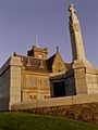
The Lerwick war memorial was built in 1923. It was designed by Sir Robert Lorimer. The town grew again in the 1970s during the North Sea oil boom. Many new homes were built north of Staney Hill and to the south.
Lerwick's Climate

Lerwick has a cool climate all year round. It is now considered a maritime climate. This means the sea greatly affects its weather. There are not many trees on the islands. This is mostly because people cleared them for farming thousands of years ago.
Lerwick is often cloudy. It gets only about 1,110 hours of sunshine each year. February is the coldest month. High temperatures are around 5.8°C (42.4°F). August is the warmest month, with highs around 14.7°C (58.5°F). This small temperature difference is unusual for a place so far north.
The wettest months are October to January. They get over 130 mm (5.1 inches) of rain each month. May and June are the driest months. They get less than 60 mm (2.4 inches) of rain. Snow can fall from December to March. But it usually does not stay long or pile up high. Strong winds, clouds, and rain are common. This is because Lerwick is open to the North Atlantic storms.
Daylight Hours
Because it is so far north, winter months in Lerwick are very dark. On the shortest day of the year, there are only 5 hours and 49 minutes of daylight. But on the longest day of the year, daylight lasts 18 hours and 55 minutes! In summer, nights never get completely dark. The sky stays a dark blue.
The sea helps to make the climate milder. This is true even with such big changes in daylight. In many other parts of the world, places at this latitude have very harsh winters. But warm Atlantic currents keep Lerwick from freezing.
| Climate data for Lerwick (S. Screen) WMO ID: 03005; coordinates 60°08′20″N 1°11′06″W / 60.13893°N 1.18491°W; elevation 82 m (269 ft); 1991–2020 normals, extremes 1930–present |
|||||||||||||
|---|---|---|---|---|---|---|---|---|---|---|---|---|---|
| Month | Jan | Feb | Mar | Apr | May | Jun | Jul | Aug | Sep | Oct | Nov | Dec | Year |
| Record high °C (°F) | 12.8 (55.0) |
11.7 (53.1) |
13.3 (55.9) |
16.1 (61.0) |
20.7 (69.3) |
22.2 (72.0) |
23.4 (74.1) |
22.1 (71.8) |
20.7 (69.3) |
17.2 (63.0) |
13.9 (57.0) |
12.6 (54.7) |
23.4 (74.1) |
| Mean maximum °C (°F) | 9.1 (48.4) |
8.9 (48.0) |
9.9 (49.8) |
11.9 (53.4) |
15.1 (59.2) |
16.2 (61.2) |
17.8 (64.0) |
17.8 (64.0) |
16.1 (61.0) |
13.4 (56.1) |
11.1 (52.0) |
10.2 (50.4) |
18.8 (65.8) |
| Mean daily maximum °C (°F) | 6.1 (43.0) |
5.8 (42.4) |
6.7 (44.1) |
8.3 (46.9) |
10.6 (51.1) |
12.6 (54.7) |
14.4 (57.9) |
14.7 (58.5) |
13.0 (55.4) |
10.4 (50.7) |
8.1 (46.6) |
6.6 (43.9) |
9.8 (49.6) |
| Daily mean °C (°F) | 4.1 (39.4) |
3.8 (38.8) |
4.6 (40.3) |
6.1 (43.0) |
8.1 (46.6) |
10.3 (50.5) |
12.2 (54.0) |
12.6 (54.7) |
11.1 (52.0) |
8.5 (47.3) |
6.2 (43.2) |
4.5 (40.1) |
7.7 (45.9) |
| Mean daily minimum °C (°F) | 2.2 (36.0) |
1.8 (35.2) |
2.4 (36.3) |
3.8 (38.8) |
5.6 (42.1) |
8.1 (46.6) |
10.1 (50.2) |
10.5 (50.9) |
9.1 (48.4) |
6.6 (43.9) |
4.3 (39.7) |
2.5 (36.5) |
5.3 (41.5) |
| Mean minimum °C (°F) | −2.3 (27.9) |
−3.2 (26.2) |
−2.6 (27.3) |
−0.7 (30.7) |
1.1 (34.0) |
4.3 (39.7) |
6.8 (44.2) |
6.8 (44.2) |
5.0 (41.0) |
1.8 (35.2) |
−0.5 (31.1) |
−2.7 (27.1) |
−4.3 (24.3) |
| Record low °C (°F) | −8.9 (16.0) |
−7.4 (18.7) |
−8.3 (17.1) |
−5.7 (21.7) |
−2.2 (28.0) |
−0.6 (30.9) |
3.5 (38.3) |
2.8 (37.0) |
−0.6 (30.9) |
−3.3 (26.1) |
−5.7 (21.7) |
−8.2 (17.2) |
−8.9 (16.0) |
| Average precipitation mm (inches) | 150.4 (5.92) |
122.7 (4.83) |
109.2 (4.30) |
67.8 (2.67) |
56.9 (2.24) |
59.8 (2.35) |
67.7 (2.67) |
88.6 (3.49) |
105.8 (4.17) |
130.6 (5.14) |
143.2 (5.64) |
149.7 (5.89) |
1,252.3 (49.30) |
| Average precipitation days (≥ 1.0 mm) | 22.0 | 19.2 | 19.3 | 14.7 | 11.7 | 11.5 | 12.1 | 13.1 | 16.1 | 20.3 | 21.5 | 22.6 | 204.1 |
| Average snowy days | 10 | 9 | 9 | 5 | 1 | 0 | 0 | 0 | 0 | 1 | 5 | 8 | 48 |
| Average relative humidity (%) | 87 | 86 | 86 | 87 | 88 | 89 | 90 | 91 | 90 | 89 | 87 | 87 | 89 |
| Mean monthly sunshine hours | 27.4 | 57.6 | 97.7 | 141.2 | 191.9 | 147.7 | 128.6 | 132.4 | 99.5 | 75.1 | 38.3 | 20.6 | 1,158 |
| Source 1: Met Office NOAA (relative humidity and snow days 1961–1990) Infoclimat | |||||||||||||
| Source 2: KNMI | |||||||||||||
| Climate data for Lerwick | |||||||||||||
|---|---|---|---|---|---|---|---|---|---|---|---|---|---|
| Month | Jan | Feb | Mar | Apr | May | Jun | Jul | Aug | Sep | Oct | Nov | Dec | Year |
| Average sea temperature °C | 9.3 |
8.8 |
8.6 |
8.8 |
9.9 |
11.5 |
13.0 |
13.4 |
12.8 |
11.9 |
11.4 |
10.3 |
10.8 |
| Mean daily daylight hours | 7.0 | 10.0 | 12.0 | 14.0 | 17.0 | 19.0 | 17.0 | 15.0 | 13.0 | 10.0 | 8.0 | 6.0 | 12.4 |
| Average Ultraviolet index | 0 | 1 | 2 | 3 | 4 | 5 | 5 | 4 | 3 | 1 | 0 | 0 | 2.4 |
| Source: Weather Atlas | |||||||||||||
People of Lerwick
In 2011, Lerwick had 6,958 residents. Most people (97.0%) are White. This includes White Scottish (83.3%) and White Other British (8.9%). About 2.2% of residents are Asian or Asian Scottish. Other groups make up 0.8%.
About 2.5% of people in Lerwick are unemployed. Many work part-time (17.3%). Most people (50.3%) have full-time jobs.
Economy and Industry
Lerwick is a busy port for fishing boats and ferries. The harbor also helps ships that work with the offshore oil industry.
Power Supply
The main power for Lerwick comes from the Lerwick Power Station. It is located in Gremista.
Famous Buildings and Places

Some important buildings in Lerwick include Fort Charlotte and Lerwick Town Hall. Other notable places are the Böd of Gremista, Shetland Museum, and Broch of Clickimin.
Some parts of the BBC TV show Shetland were filmed in Lerwick. This is because the area has a lot of history.
Getting Around Lerwick
Lerwick is served by two airports. Tingwall Airport is a few miles away. Sumburgh Airport is further south. It has flights all year to some places in Scotland.
NorthLink Ferries runs a daily overnight ferry. It travels between Lerwick and Aberdeen. It often stops at Kirkwall in the Orkney Islands.
The Shetland Islands Council also runs a ferry service. These ferries carry cars and people. They go to Out Skerries and Bressay from a terminal in the town center.
Local buses are run by the Regional Transport Partnership (ZetTrans). Different local companies operate the buses. The town has a bus station called Viking bus station.
Schools and Learning
The main secondary school in Lerwick is Anderson High School.
Shetland College is also in Lerwick. It is part of the University of the Highlands and Islands. It offers college-level courses. This helps local students who might find it hard to travel far away for studies.
Hospitals and Healthcare
The Gilbert Bain Hospital provides medical care for all of Shetland. The Montfield Hospital is an older hospital nearby. It also helps with healthcare for people in Lerwick.
Sports and Activities

Lerwick has four football teams. They are Lerwick Spurs, Lerwick Thistle, Lerwick Celtic, and Lerwick Rangers. The Clickimin Leisure Complex offers sports facilities. It has a swimming pool and open courts for the town.
Media and News
Television signals come from the Bressay TV transmitter. The local radio station, SIBC, broadcasts daily from Market Street. BBC Radio Shetland has its studios in Pitt Lane.
The Shetland Times is a weekly local newspaper. Its office is in Gremista. Millgaet Media Group, a company that makes different types of media, is at the North Ness Business Park.
Culture and Traditions
Lerwick has strong connections with Scandinavian countries. It has a friendship agreement with Måløy in Norway.
Local Events
Lerwick is where most of Shetland's events happen. This includes the biggest Up Helly Aa fire festival. This festival takes place every year on the last Tuesday of January.
Places of Worship
There are several churches in Lerwick:
- Adam Clarke Memorial Methodist Church (part of the Methodist Church of Great Britain).
- Baptist Church, Clairmont Place.
- St. Columba's Church – one of three buildings of Lerwick and Bressay Parish Church (part of the Church of Scotland).
- St. Magnus' Church, Greenfield Place (part of the Scottish Episcopal Church).
- St. Margaret's Roman Catholic Church.
In the 1800s, there were more churches in Lerwick. This included a Free Church. There are plans to turn the old Lochside Stores building into a mosque.
Gallery
-
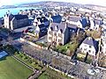
Jubilee Park, King Harald St and Southern Lerwick toward Lower Sound
-
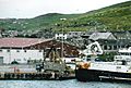
Lerwick Harbour
-
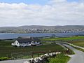
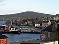
View of Lerwick from Bressay
-
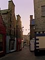
Commercial Street
-
Lerwick Town Hall
-
Lerwick from Fort Charlotte


See also
 In Spanish: Lerwick para niños
