Ring of Brodgar facts for kids

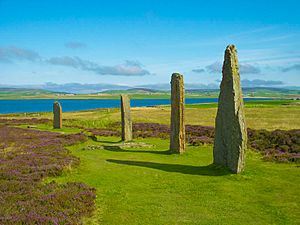
The ring with Loch of Harray beyond
|
|
| Location | Mainland, Orkney, Scotland |
|---|---|
| Coordinates | 59°00′07″N 3°13′43″W / 59.0020°N 3.2287°W |
| Type | Standing stones, Henge |
| History | |
| Periods | Neolithic |
| Site notes | |
| Ownership | Historic Scotland |
| Public access | Yes |
| Type | Cultural |
| Criteria | i, ii, iii, iv |
| Designated | 1999 (23rd session) |
| Part of | Heart of Neolithic Orkney |
| Reference no. | 514 |
| State Party | Scotland |
| Region | Western Europe |
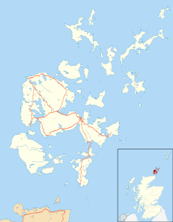
The Ring of Brodgar is a very old stone circle and a special type of ditch called a henge. It is located on Mainland, which is the biggest island in Orkney, Scotland. This amazing place is part of a UNESCO World Heritage Site. This means it is a very important place that the United Nations wants to protect for everyone to see. The site is known as the Heart of Neolithic Orkney.
The stone circle is about 104 metres (341 ft) wide. This makes it the third largest stone circle in the British Isles. When it was first built, there were 60 large stones. Today, only 27 of these stones are still standing. The tallest stones are found on the south and west sides of the circle.
The stones stand inside a circular ditch. This ditch is up to 3 metres (9.8 ft) deep and 9 metres (30 ft) wide. It goes around for about 380 metres (1,250 ft). Ancient people carved this ditch out of solid sandstone rock. Even though it's called a henge, it doesn't have an earth bank around it. Still, many experts call it a henge. It has two entrances, one on the north-west and one on the south-east.
Contents
What is the Ring of Brodgar?
The Ring of Brodgar is a huge stone circle from the Neolithic period. This was a time long ago when people first started farming. It's also a henge, which is a circular area of land. Henges usually have a ditch and an outer bank. The Ring of Brodgar is special because its ditch was carved into rock.
How big is the Ring of Brodgar?
The stone circle itself is very large, measuring about 104 meters (341 feet) across. This makes it one of the biggest stone circles in Britain. Imagine a circle wide enough to fit many houses inside!
How many stones are there?
Originally, there were 60 standing stones in the circle. Over thousands of years, some have fallen or been removed. Today, 27 stones are still standing tall. The tallest stones are found on the south and west sides of the circle.
What is a henge?
A henge is a type of ancient monument. It is usually a circular area enclosed by a ditch and an outer bank. The Ring of Brodgar has a deep ditch carved into the rock. This ditch is about 3 meters (10 feet) deep and 9 meters (30 feet) wide. It forms a circle about 380 meters (1,247 feet) around.
What was the area used for?
The Ring of Brodgar is part of a very important ancient area. Within a small space of about 2 square miles (5.2 km2), there are many other ancient sites. These include other stone circles, burial tombs, single standing stones, and mounds. People have also found old flint arrowheads and broken stone mace-heads nearby. These items suggest the area was important for ceremonies or gatherings.
The nearby Stones of Stenness and the Maeshowe tomb are also very important. Together, these sites show that the area around the Ring of Brodgar was a major center for ancient people. They likely used it for special events, rituals, or to observe the sky.
Images for kids
See also
 In Spanish: Anillo de Brodgar para niños
 | Selma Burke |
 | Pauline Powell Burns |
 | Frederick J. Brown |
 | Robert Blackburn |


