
Orkney facts for kids
| Gaelic name | Arcaibh |
|---|---|
| Norse name | Orkneyjar |
| Meaning of name | "Ork" possibly originally from a Pictish tribal name meaning 'young pig'. |
 Flag
 Coat of arms
|
|
| Coordinates | 59°00′N 3°00′W / 59.000°N 3.000°W |
| Physical geography | |
| Island group | Northern Isles |
| Area | 990 km2 (380 sq mi) |
| Highest elevation | Ward Hill 481 m (1,578 ft) |
| Administration | |
| Sovereign state | United Kingdom |
| Country | Scotland |
| Council area | Orkney Islands Council |
| Demographics | |
| Population | 22,540 (2021) |
| Population density | 23/km2 (59/sq mi) |
| Largest settlement | Kirkwall |
Orkney, also known as the Orkney Islands, is a group of islands (an archipelago) located off the north coast of Scotland. These islands are part of the Northern Isles. Orkney is about 10 miles (16 km) north of Caithness. It has around 70 islands, and 20 of them have people living on them.
The biggest island is called the Mainland. It covers 523 square kilometers. This makes it the sixth-largest Scottish island and the tenth-largest island in the British Isles. Kirkwall is the biggest town in Orkney and also its main administrative center.
Orkney is one of Scotland's 32 local government areas. It is also a special area for the Scottish Parliament and a historic county. The local government is the Orkney Islands Council. It is one of only three councils in Scotland where most elected members are independent.
People have lived on the Orkney islands for at least 8,500 years. Early tribes like the Mesolithic and Neolithic people lived there first, followed by the Picts. In 875, the Kingdom of Norway took control of Orkney. Many Norsemen settled there. In 1472, Orkney became part of the Kingdom of Scotland. This happened because a promised payment (a dowry) for James III of Scotland's marriage to Margaret of Denmark was not paid.
Besides the Mainland, most other islands are grouped into the North Isles and the South Isles. Orkney has a mild climate and very fertile soil. Most of the land is used for farming, which is the most important part of the economy. The islands also have a lot of wind and sea energy. They produce more electricity from renewable sources than they need. Temperatures usually range from 7°C (45°F) in winter to 16°C (61°F) in summer.
People from Orkney are called Orcadians. They speak a special dialect of the Scots language. They also have many interesting old stories and traditions. Orkney is home to some of Europe's oldest and best-preserved Stone Age sites. The "Heart of Neolithic Orkney" is a special place recognized by UNESCO as a World Heritage Site. Orkney also has a lot of amazing sea and bird wildlife.
Contents
Understanding the Name of Orkney
The name "Orkney" has a long history. Around 322 to 285 BC, a Greek explorer named Pytheas visited Britain. He described a northern tip called Orcas, which might have been Dunnet Head. From there, you can see Orkney. Later, in the 1st century AD, Roman writers like Ptolemy and Pomponius Mela called the islands Orcades.
Experts believe the word orc- in the name comes from a Pictish tribal name. It likely meant "young pig" or "young boar". In Old Irish, the islands were called Insi Orc, meaning "islands of the young pigs".
When Norwegian settlers arrived in the late 800s, they changed the meaning of orc. They thought it came from the Old Norse word orkn, which means "seal". They added eyjar, meaning "islands", so the name became Orkneyjar, or "Seal Islands". Over time, the "jar" part was dropped in English, leaving the name Orkney.
The largest island, Mainland, Orkney, was known as Megenland ("Mainland") or Hrossey ("Horse Island") by the Norse.
Orkney's Past: A Journey Through Time
Ancient Times: Prehistory in Orkney

Evidence shows that people lived in Orkney as far back as 6820–6660 BC. This was discovered from a burnt hazelnut shell found during digs in Tankerness. The oldest known permanent home is at Knap of Howar. This Stone Age farm on Papa Westray dates back to 3500 BC.
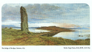
The village of Skara Brae is Europe's best-preserved Stone Age settlement. It was likely lived in from about 3100 BC. Other important ancient sites include the Standing Stones of Stenness, the Maeshowe passage grave, and the Ring of Brodgar. Many of these Stone Age villages were left empty around 2500 BC, possibly due to climate changes.
In 2021, archaeologists found two smooth stone balls in a 5,500-year-old Stone Age burial tomb on Sanday. One was described as "the size of a cricket ball, perfectly spherical and beautifully finished."
During the Bronze Age, fewer large stone buildings were made. Metalworking slowly came to Britain from Europe. There are not many Orkney sites from this time. However, there is the impressive Plumcake Mound near the Ring of Brodgar.
The Iron Age in Orkney

Digs at Quanterness on the Mainland show a roundhouse built around 700 BC. Similar finds were made at Bu and Pierowall Quarry. The most impressive Iron Age buildings in Orkney are the ruins of tall, round towers called "brochs." Examples include the Broch of Burroughston and Broch of Gurness.
When the Romans invaded Britain, the "King of Orkney" was one of 11 British leaders who gave up to Emperor Claudius in 43 AD. Roman influence in Orkney seems to have been mostly through trade, not conquest.
By the late Iron Age, Orkney was part of the Pictish kingdom. The fertile land and rich seas likely provided a good life for the Picts. Later, Celtic missionaries started to influence the islands. However, the Picts were slowly replaced by North Germanic peoples from the late 700s onwards.
Viking Rule in Orkney

Orkney and Shetland saw many Norwegian settlers arrive in the late 700s and early 800s. Vikings used the islands as a base for their raids against Norway and Scotland. In response, Norwegian king Harald Fairhair took control of Orkney and Shetland in 875. Rognvald Eysteinsson was given Orkney and Shetland as an earldom. He then passed it to his brother Sigurd the Mighty.
Torf-Einarr, Rognvald's son, started a family line that ruled the islands for centuries. His son Thorfinn Skull-splitter followed him. During this time, the Norwegian King Eric Bloodaxe often used Orkney as a raiding base.

The Orkneyinga Saga says that Olaf Tryggvasson made the islands Christian in 995. He stopped at South Walls and told the jarl Sigurd the Stout to be baptized. Sigurd agreed, and Orkney became Christian. They even got their own bishop in the early 1000s.

Thorfinn the Mighty was a grandson of King Malcolm II of Scotland. He ruled Orkney in the first half of the 11th century. He even controlled a small sea empire from Dublin to Shetland. After Thorfinn died around 1065, his sons Paul and Erlend took over. They fought at the Battle of Stamford Bridge in 1066.
Paul and Erlend later argued, and this fight continued with their children. The death of Magnus Erlendsson in 1116, killed by his cousin Haakon Paulsson, led to the building of St Magnus Cathedral. This church is still a major landmark in Kirkwall today.
From about 1100, the Norse jarls (earls) were loyal to both Norway for Orkney and to the Scottish crown for their lands in Caithness. In 1231, the line of Norse earls ended. The earldom then passed to Magnus, who was confirmed as Earl of Orkney in 1236 by Haakon IV of Norway.

In 1290, the young princess Margaret, Maid of Norway died in Orkney on her way to Scotland. Her death caused a big argument over who should be the next king of Scotland. This eventually led to the Wars of Scottish Independence. In 1379, the earldom went to the Sinclair family.
Many signs of the Viking presence can still be seen today. These include the settlement at the Brough of Birsay, most of the place names, and the runic writings at Maeshowe.
Orkney Becomes Part of Scotland

In 1468, Christian I of Denmark, who was also King of Norway, offered Orkney as a guarantee. This was to secure the payment of his daughter Margaret's dowry for her marriage to James III of Scotland. However, the money was never paid. Because of this, Orkney officially became part of the Kingdom of Scotland in 1472.
Before this time, Orkney's history was mostly about its rulers. But after 1472, the lives of ordinary people became clearer. Many Scottish business people moved to Orkney. They helped create a diverse community of farmers, fishermen, and merchants. These people called themselves comunitas Orcadie (the community of Orkney). They became very good at protecting their rights against their feudal lords.
From the 1500s, boats from Scotland and the Netherlands controlled the local herring fishing. Orkney's own fishing fleet did not grow much until the 1800s. But then it grew quickly, with 700 boats by the 1840s.

Farming methods improved starting in the 1600s. This led to larger, well-managed farms in the Victorian era. These farms used a system of rotating crops and produced high-quality beef cattle.
In the 1600s, most employees of the Hudson's Bay Company in Canada were Orcadians. Their ability to handle boats and the harsh Orkney winters made them perfect for the tough conditions in Canada. For a short time, burning kelp (seaweed) was important for the islands' economy. This was used to make soda ash. But this industry suddenly ended in 1830.
During the Jacobite risings in the 1700s, many people in Orkney supported the Jacobites. Orkney was the last place in the British Isles to hold out for the Jacobites. The British Government did not take it back until May 24, 1746.
Orkney in the 20th Century

Orkney was home to a Royal Navy base at Scapa Flow. This base was very important in World War I and World War II. After World War I, the German High Seas Fleet was brought to Scapa Flow. The German sailors opened the seacocks and sank all their ships. Most of these ships were later brought up from the sea. The remaining wrecks are now popular for divers.
One month into World War II, a German U-boat sank the battleship HMS Royal Oak in Scapa Flow. After this, barriers were built to block most of the sea channels. These barriers also created roads, allowing people to travel between islands by car instead of only by ferry. Italian prisoners of war built these causeways. They also built the beautiful Italian Chapel.
The navy base closed in 1957. The population of Orkney decreased after the war. However, in the late 1900s, the population started to grow again. Life in Orkney focused on increasing wealth and a more equal society. Orkney was named the best place to live in Scotland in 2013 and 2014. In 2019, it was even called the best place to live in the UK.
Changes in Population Over Time
The population of Orkney reached its highest point in the mid-1800s, with over 32,000 people. It then went down for a century, reaching a low of fewer than 18,000 in the 1970s. Some smaller islands were especially affected by these population drops. However, the population grew by 11% in the ten years leading up to the 2011 census.
Orkney's Geography

Orkney is separated from mainland Scotland by the Pentland Firth. This is a 10 km (6 mi) wide sea channel between South Ronaldsay and Duncansby Head in Caithness. Orkney stretches 80 km (50 mi) from northeast to southwest and 47 km (29 mi) from east to west. It covers 975 square kilometers (376 sq mi).
The Shetland Islands are further out and separated from Orkney by the Fair Isle Channel.
Most of the islands are low and flat. However, there are some steep sandstone hills on Mainland, Rousay, and Hoy. Ward Hill on Hoy is the highest point in Orkney. Some western coasts have rugged cliffs. Almost all the islands have lochs (lakes), but the rivers are just small streams. The coastlines have many inlets, and the islands are separated by narrow sea channels called "sounds" or "firths."
The tidal currents around many of the islands are very strong, with frequent whirlpools. The islands do not have many trees, partly because of the strong winds.
Main Settlements in Orkney
| Settlement | Population (2020) |
|---|---|
| Kirkwall | 7500 |
| Stromness | 1790 |
| Finstown | 500 |
| Balfour | < 500 |
| Dounby | < 500 |
| Houton | < 500 |
| Longhope | < 500 |
| Lyness | < 500 |
| Pierowall | < 500 |
| St Margaret's Hope | < 500 |
| Whitehall | < 500 |
| Island | Population (2011) |
|---|---|
| Orkney Mainland | 17,162 |
| South Ronaldsay | 909 |
| Westray | 588 |
| Sanday | 494 |
| Hoy | 419 |
| Burray | 409 |
| Stronsay | 349 |
| Shapinsay | 307 |
| Rousay | 216 |
| Eday | 160 |
Orkney's Rocks and Landforms (Geology)

The surface rock in Orkney is almost all Old Red Sandstone. This rock formed during the Middle Devonian period. This sandstone sits on top of older metamorphic and igneous rocks. You can see these older rocks between Stromness and Inganess on the Mainland.
The Middle Devonian rocks are divided into three main groups. The lower part has layers of Stromness Flagstones. These formed in a large ancient lake called Lake Orcadie. The later Rousay flagstone formation is found across many of the North and South Isles and East Mainland.

The famous Old Man of Hoy is made from sandstone of the Eday Group. This rock can be up to 800 meters (870 yd) thick in some places.
Many cracks (faults) run through Orkney's rocks. These faults were active when the Devonian layers were forming. A large fold in the rock (a syncline) goes through Eday and Shapinsay.
Volcanic rocks from the Middle Devonian period are found on western Hoy, Deerness, and Shapinsay. Evidence of glaciers and rocks like chalk and flint show that ice shaped the islands' landforms. Large amounts of boulder clay and moraines also cover the area.
Orkney's Weather (Climate)
Orkney has a cool, mild climate. This is unusual for such a northern place. It is because of the warm waters of the Norwegian Current, which is part of the Gulf Stream. The average temperature for the year is 8°C (46°F). In winter, it's about 4°C (39°F), and in summer, it's about 12°C (54°F).
The average yearly rainfall is between 850 mm (33 in) and 940 mm (37 in). Winds are a big part of the climate. Even in summer, there are almost always breezes. In winter, strong winds are common, with gales happening for about 52 hours each year.
For visitors, the "nightless" summers are fascinating. On the longest day, the sun rises at 4:00 AM and sets at 10:29 PM. It never gets completely dark. This long twilight is called the "simmer dim" in the Northern Isles. Winter nights are long. On the shortest day, the sun rises at 9:05 AM and sets at 3:16 PM. Sometimes, the aurora borealis (Northern Lights) can be seen in the northern sky during winter.
How Orkney is Governed
.jpg)
In 1889, a new system of county councils was set up in Scotland. This led to the creation of the Orkney County Council in 1890. Its main office was at the County Buildings in Kirkwall.
Today, Orkney is managed by the Orkney Islands Council. This is a single unitary council for the islands. It was created in 1975 as part of a local government change in Scotland. In that year, Scotland's old civil parishes were replaced by Community Council Areas. These new areas give advice but do not have administrative power. Orkney has 20 Community Council Areas.
Orkney's Islands
The Mainland Island

The Mainland is the biggest island in Orkney. Both of Orkney's main towns, Kirkwall and Stromness, are on this island. The Mainland is also the center of Orkney's transportation. It has ferry and air links to the other islands and the rest of the world.
About 75% of Orkney's population lives on the Mainland. The island has a lot of fertile farmland. The Mainland is divided into East and West Mainland, based on whether they are east or west of Kirkwall. Most of the Mainland is west of Kirkwall.
The island is mostly low and flat, especially East Mainland. But it has coastal cliffs in the north and west. There are also two large lochs: the Loch of Harray and the Loch of Stenness. The Mainland has many ancient sites from the Neolithic, Pictish, and Viking times. Four of the main Neolithic sites are part of the Heart of Neolithic Orkney World Heritage Site.
The other islands in Orkney are grouped as either north or south of the Mainland. The remote islets of Sule Skerry and Sule Stack are exceptions. They are 60 km (37 mi) west of the main group but are part of Orkney for local government. In island names, "a" or "ay" comes from the Norse word ey, meaning "island." Islands called "holms" are very small.
The North Isles

The northern group of islands is the largest. It has many medium-sized islands connected to the Mainland by ferries and flights. Farming, fishing, and tourism are the main ways people earn money on most of these islands.
The most northerly island is North Ronaldsay. It is 4 km (2.5 mi) from its closest neighbor, Sanday. To the west is Westray, which has a population of 550. It is connected by ferry and air to Papa Westray, also known as "Papay." Eday is in the middle of the North Isles. Its center is moorland, and its main industries have been digging for peat and limestone.
Rousay, Egilsay, and Gairsay are north of the west Mainland, across the Eynhallow Sound. Rousay is famous for its ancient monuments, like the Quoyness chambered cairn. Egilsay has the ruins of Orkney's only round-towered church. Wyre, to the southeast, has the site of Cubbie Roo's castle. Stronsay and Papa Stronsay are further east. Auskerry is south of Stronsay and has only five people living there. Shapinsay and its Balfour Castle are a short distance north of Kirkwall.
Other small, uninhabited islands in the North Isles include Calf of Eday, Damsay, Eynhallow, Faray, Helliar Holm, Holm of Faray, Holm of Huip, Holm of Papa, Holm of Scockness, Kili Holm, Linga Holm, Muckle Green Holm, Rusk Holm, and Sweyn Holm.
The South Isles

The southern group of islands surrounds Scapa Flow. Hoy, to the west, is the second-largest Orkney island. Ward Hill on Hoy is the highest point in Orkney. The Old Man of Hoy is a famous sea stack.
Graemsay and Flotta are connected by ferry to the Mainland and Hoy. Flotta is known for its large oil terminal. South Walls has a 19th-century Martello tower and is connected to Hoy by the Ayre. Burray is east of Scapa Flow and linked by a road (causeway) to South Ronaldsay. South Ronaldsay hosts events like the Festival of the Horse and the Boys' Ploughing Match. It is also home to the Neolithic Tomb of the Eagles. South Ronaldsay, Burray, Glimps Holm, and Lamb Holm are connected to the Mainland by road through the Churchill Barriers.
Uninhabited South Islands include Calf of Flotta, Cava, Copinsay, Corn Holm, Fara, Glimps Holm, Hunda, Lamb Holm, Rysa Little, Switha, and Swona. The Pentland Skerries are further south, closer to mainland Scotland.
Orkney's Economy
Orkney's soil is very fertile, and most of the land is used for farms. Farming is the most important part of the economy. It provides jobs for a quarter of the workers. More than 90% of farmland is used for grazing sheep and cattle. About 4% (4,200 hectares) is used for growing cereals. Only 134 hectares are woodland.
Fishing has become less important, but it still employed 345 people in 2001. This was about 3.5% of the working population. The modern fishing industry focuses on herring, white fish, lobsters, crabs, other shellfish, and salmon fish farming.
Orkney exports beef, cheese, whisky, beer, fish, and other seafood. In recent years, other areas have grown. These include tourism, making food and drinks, jewelry, knitwear, and other crafts. Construction and oil transport through the Flotta oil terminal are also important. Retail (shops) accounts for 17.5% of all jobs. Public services also play a big role, employing a third of the island's workers. Orkney has two Scotch whisky distilleries: Scapa distillery and the Highland Park distillery. A third whisky distillery, Deerness Distillery, is expected to open in summer 2023.
In 2007, 55% of businesses were in farming, forestry, and fishing. 12% were in manufacturing and construction, and 12% in shops and repairs. 5% were in hotels and restaurants, and another 5% were related to public services. Most of these businesses (55%) employ between 5 and 49 people.
A report from September 2020 said there are about 1,500 businesses on the island. More than 90% have fewer than 10 employees. It estimated 11,000 jobs, with about 5,000 being part-time. There is not much manufacturing, except for food and drink processing like cheese and whisky. Apart from the Flotta oil terminal, there are no other big private employers. Fishing is only half as important for jobs as in Shetland, but farming is about twice as important.
The report also worried about businesses being affected by the worldwide COVID-19 pandemic. This greatly impacted business, travel, and tourism. In February 2021, the Scottish government announced a new plan to help businesses in Orkney and other island areas.
Visiting Orkney (Tourism)

Tourism is a big part of Orkney's economy. Visitor spending increased from £49.5 million in 2017 to £67.1 million in 2019. The main attractions are the "Heart of Neolithic Orkney" on the main island. This includes 5,000-year-old sites like the preserved village of Skara Brae and the Ring of Brodgar stone circle. The landscape of Hoy is also popular, with its woods, steep valleys, high cliffs, and the famous Old Man of Hoy sea stack. In 2017, 62% of tourists visited Orkney for its history and heritage. The UHI Archaeology Institute's digs at the Ness of Brodgar have also boosted tourism and interest in archaeology.
Most years, Orkney hosts several international festivals. These include the Orkney International Science Festival in September, a folk festival in May, and the St Magnus International Arts Festival in June.
However, the number of visitors arriving by ferry dropped by 71% in 2020 due to the COVID-19 pandemic. Cruise ships also stopped coming. Several major events were canceled, including the St Magnus Festival and the Orkney Folk Festival.
Power and Energy

Orkney has a lot of wind and sea energy. Renewable energy has become very important. Orkney produces more than 100% of its electricity from renewable sources, mainly from wind turbines.
The European Marine Energy Centre (EMEC) is a research center. It tests wave energy devices off the west coast of the Orkney Mainland. It also tests tidal power devices in the Fall of Warness, near Eday. This site was the first in the world built to test wave and tidal energy devices.
Orkney has one of the highest numbers of electric vehicles in the UK. More than 2% of the vehicles on the road were electric in 2019.
Making Hydrogen Energy
A 2019 report said that "Orkney creates more clean electricity than its inhabitants need." Even after sending power to the UK national grid, the islands' winds, waves, and tides generate about 130% of the electricity needed. All of this comes from clean sources. One idea is to turn this extra renewable power into another fuel, like hydrogen, and then store it.
In May 2020, CNN reported that Orkney's success in making hydrogen from clean energy shows it can be done on a large scale. The islands are already using hydrogen to power vehicles. It will soon be used to heat a local primary school. Orkney also hopes to use hydrogen fuel cells to power a sea vessel for goods and passengers.
In late 2020, Orkney Islands Council provided more details about the hydrogen plan. A report also said that the world's first hydrogen-fueled ferry would be tested in Orkney. It would use a "hydrogen/diesel dual fuel conversion system."
Kirkwall Airport in Orkney is also planning to use green hydrogen for its heating and power starting in 2021. This project aims to reduce pollution from older heating systems. This is part of Scotland's plan for the Highlands and Islands to become the world's first "net zero aviation region" by 2040.
Hydrogen production is also planned for Shetland and other parts of Scotland with access to clean electricity. The government has announced a £100 million investment in the hydrogen sector to help achieve this.
Getting Around (Transport)
Air Travel
Highland and Islands Airports runs Orkney's main airport, Kirkwall Airport. Loganair offers flights to mainland Scotland (Aberdeen, Edinburgh, Glasgow, and Inverness). They also fly to Sumburgh Airport in Shetland.
Within Orkney, the council operates airports on most of the larger islands. These include Stronsay, Eday, North Ronaldsay, Westray, Papa Westray, Sanday, and Flotta. The shortest scheduled air service in the world is between Westray and Papa Westray. It is scheduled for two minutes but can take less than one minute with a good wind.
Ferry Services

Ferries connect Orkney to the rest of Scotland and also link the different islands within Orkney. Ferry services operate between Orkney and mainland Scotland and Shetland on these routes:
- Gills Bay to St Margaret's Hope (by Pentland Ferries)
- John o' Groats to Burwick on South Ronaldsay (a seasonal passenger-only service)
- Lerwick to Kirkwall (by NorthLink Ferries)
- Aberdeen to Kirkwall (by NorthLink Ferries)
- Scrabster Harbour, Thurso to Stromness (by NorthLink Ferries)
Inter-island ferry services connect all the inhabited islands to the Orkney Mainland. These are run by Orkney Ferries, which is owned by Orkney Islands Council. Islands like Westray, Papa Westray, North Ronaldsay, Sanday, Eday, Stronsay, and Shapinsay are served from Kirkwall harbor. The northern part of Hoy and Graemsay are served from Stromness harbor. The Lyness end of Hoy, Longhope on South Walls, and Flotta are served from Houton on the south of the Mainland. Rousay, Egilsay, and Wyre are served from Tingwall on the Orkney Mainland. The MV Golden Mariana also connects Pierowall on Westray with Papa Westray. This is important for schoolchildren on Papay.
Bus Services
Local buses around the Orkney Mainland and across the Churchill Barriers to Burray and South Ronaldsay are run by Stagecoach Highlands. The main route, the X1, connects Stromness, Stenness (for Maeshowe), Finstown, Kirkwall, St Mary's, Burray, and St Margaret's Hope. There are also buses from Kirkwall via Orphir (2), and from Stromness (5) to the ferry terminal at Houton. Other routes connect Kirkwall to Kirkwall Airport (3 & 4), Tankerness and Deerness (3). Buses also run from Kirkwall and Finstown to Tingwall (for ferries to Rousay, Egilsay, and Wyre), Evie, and Birsay. The 7 route goes from Stromness to Kirkwall via Skara Brae, Dounby, Harray, and Finstown. The 8 route does a circular trip to and from Kirkwall and Finstown via Stromness and West Mainland villages. The X10 connects the late-night NorthLink ferry at Hatston Ferry Terminal to Kirkwall, Finstown, and Stromness.
In 2021, the island's minibus service for disabled people was targeted by hackers. They demanded a £1,000 ransom in cryptocurrency.
Media in Orkney
Orkney has a weekly local newspaper called The Orcadian, published on Thursdays. It started in 1854. It is part of the Orkney Media Group, which was formed in 2007 with another newspaper, Orkney Today.
BBC Radio Orkney is a local BBC radio station. It broadcasts twice daily with local news and entertainment. Orkney also had a commercial radio station, The Superstation Orkney, which broadcast to Kirkwall and parts of the Mainland and Caithness until it closed in 2014. MFR broadcasts throughout Orkney. The community radio station Caithness FM also broadcasts to Orkney.
Orkney is home to the Orkney Library and Archive in Kirkwall. The library has over 145,000 items, including books, audiobooks, maps, eBooks, music CDs, and DVDs. The Orkney Library and Archive also has a Mobile Library Service. This service visits rural areas and islands of Orkney. The Mobile Library carries many books and audiobooks for all ages and is free to use.
Language, Stories, and Traditions
At the start of recorded history, the Picts lived on the islands. Their language was Brythonic. After the Norse arrived, most place names in Orkney became West Norse. The Norse language changed into the local Norn. This language was spoken until the late 1700s, when it died out.
Norn was replaced by the Orcadian dialect of Insular Scots. This dialect is not as widely used now due to TV, education, and many new people moving to the islands. However, some writers and radio hosts are trying to bring it back. The unique singing accent and many dialect words of Norse origin are still used. A common Orcadian word visitors hear is peedie, meaning 'small'. This might come from the French word petit.
Orkney has many rich folk tales. Many old stories are about trows, which are an Orcadian type of troll. These stories show the islands' connections to Scandinavia. In the past, local customs included marriage ceremonies at the Odin Stone, which was part of the Stones of Stenness.
In some versions of the Arthurian legend, King Lot is the ruler of Orkney. His sons Gawaine, Agravaine, Gareth, and Gaheris are important characters in these stories.
Well-known writers from modern Orkney include the poet Edwin Muir, the poet and novelist George Mackay Brown, and the novelist Eric Linklater.
Who are Orcadians?
An Orcadian is someone born in Orkney. People from Orkney have a strong sense of identity. Even though Orkney became part of Scotland over 500 years ago in 1472, some Orcadians see themselves as Orcadians first and Scots second. However, in the 2011 Scotland Census, the number of people who identified as Scottish in Orkney was similar to the national average.
People in Orkney often call mainland Scotland "Scotland." They refer to Mainland, Orkney as "the mainland." The islands also have their own distinct culture. Traditions like tartan, clans, and bagpipes, common in the Scottish Highlands, are not native to Orkney. However, at least two tartans with Orkney connections have been registered. There are also pipe bands in Orkney.
Native Orcadians call people who are not from the islands "ferry loupers." This term has been used for at least two centuries. "Loup" means "jump" in the Scots language.
Orkney's Amazing Wildlife (Natural History)

Orkney has a lot of wildlife. You can see many grey and common seals. There are also many seabirds like puffins, kittiwakes, black guillemots (tysties), ravens, and great skuas (bonxies). Whales, dolphins, and otters are also seen around the coasts.
Inland, you can find the Orkney vole. This is a special type of common vole that was brought to the islands by early humans. It is found only in Orkney. There are five different kinds of Orkney voles, found on Sanday, Westray, Rousay, South Ronaldsay, and the Mainland. This is remarkable because this type of vole is not found on mainland Britain.
The coastline is known for its colorful flowers. These include sea aster, sea squill, sea thrift, common sea-lavender, bell and common heather. The Scottish primrose is found only on the coasts of Orkney and nearby Caithness and Sutherland. While trees are generally rare, a small forest called Happy Valley was created from a boggy hillside near Stenness. It has 700 trees and beautiful gardens.
The North Ronaldsay sheep is a unique type of domesticated animal. It mainly eats seaweed because these sheep are kept on the foreshore for most of the year. This helps save the limited grazing land inland. The island was also home to the Atlantic walrus until the mid-1500s.
The Orkney char (Salvelinus inframundus) used to live in Heldale Water on Hoy. It has not been seen since 1908 and is considered locally extinct there.
Dealing with the Stoat Problem

Since 2010, non-native stoats have been introduced to Orkney. Stoats are natural predators of the common vole, which includes the Orkney vole. They also harm native bird populations. NatureScot, Scotland's nature agency, explained that stoats are very dangerous to Orkney's wildlife. This includes the native Orkney vole, hen harrier, short-eared owl, and many ground-nesting birds.
In 2018, NatureScot started a project to remove stoats. This project uses "humane DOC150 and DOC200 traps." The Orkney Native Wildlife Project is a five-year effort. Its partners include RSPB Scotland, Scottish Natural Heritage, and Orkney Islands Council. A report in October 2020 said that over 5,000 traps had been set up.
However, in January 2021, The Times reported that the project faced problems. Some traps were damaged or stolen. They also accidentally caught and killed pets and other animals. Police Scotland is investigating these incidents.
Protected Natural Areas
Orkney has 13 Special Protection Areas and 6 Special Areas of Conservation. One of Scotland's 40 national scenic areas, the Hoy and West Mainland National Scenic Area, is also in the islands. The seas northwest of Orkney are important for sand eels. These eels are a food source for many fish, seabirds, seals, whales, and dolphins. This area is now protected as a Nature Conservation Marine Protected Area (NCMPA), covering 4,365 square kilometers (1,685 sq mi).
Freedom of the Island Award
Since 1887, Orkney has been connected to certain military units as a recruiting area. These units have received the Freedom of the Island of Orkney. This is an honor given to military units.
The units include:
- The Seaforth Highlanders, Queens Own Highlanders, The Highlanders Regiment, and 4th Battalion Royal Regiment of Scotland.
- The Northern Diving Group Royal Navy: This group received the honor on July 9, 2021.
Images for kids
-
Flag of Orkney
-
Coat of arms of Orkney
-
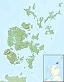
Map of Orkney Islands

See also
 In Spanish: Orcadas para niños
