Tankerness facts for kids
Quick facts for kids Tankerness |
|
|---|---|
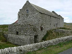 Disused grain mill at Tankerness |
|
| OS grid reference | HY511072 |
| Civil parish |
|
| Council area | |
| Lieutenancy area | |
| Country | Scotland |
| Sovereign state | United Kingdom |
| Post town | ORKNEY |
| Postcode district | KW17 |
| Dialling code | 01856 |
| Police | Northern |
| Fire | Highlands and Islands |
| Ambulance | Scottish |
| EU Parliament | Scotland |
| UK Parliament |
|
| Scottish Parliament |
|
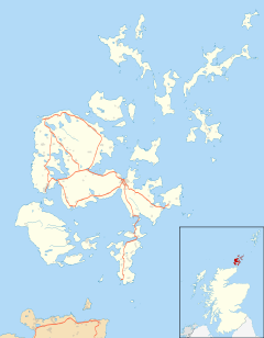
Tankerness is a lovely area in Orkney, Scotland. It's like a small arm of land, or a peninsula, reaching out into the sea. You can find it about 13 kilometers (8 miles) south-east of Kirkwall, which is a bigger town. It's also only about 1 kilometer (0.6 miles) east of Kirkwall Airport. The name "Tankerness" might come from an old Norse name, "Tannskári." The word "ness" means a piece of land that sticks out into the water.
Contents
Exploring Tankerness's Landscape
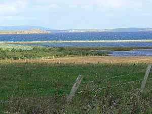
Tankerness is surrounded by water on three sides. To the north and west, you'll find Inganess Bay. To the east, there's Deer Sound. These two water areas meet at a noticeable point called Rerwick Head.
In the middle of Tankerness, there's a lake called Loch of Tankerness. It's almost 1 square kilometer (247 acres) in size. The land here is mostly flat and good for farming, unlike the hillier areas nearby. Along Inganess Bay, there's a cool natural feature called the Long Ayre. It's a kilometer-long gravel path that encloses a tidal pool.
Ancient Rocks and Land Formation
The land under Tankerness is made of special rocks called Rousay flagstones. These rocks are very old, from a time called the Middle Devonian period. They formed in a huge ancient lake known as Lake Orcadie.
Millions of years ago, the land that is now Orkney was much closer to the equator. It was in a hot, dry desert area. The layers in these lake rocks show how the lake's water level changed over time. These changes were likely due to natural climate cycles.
Discovering Tankerness's Past
Early Human Life
People have lived in Orkney for a very long time! In 2007, during an excavation at a place called Longhowe, scientists found a burnt hazelnut shell. This tiny piece of shell was dated to between 6820 and 6660 BC. This discovery showed that people were living in Orkney about 3,000 years earlier than previously thought.
Mine Howe: An Underground Mystery
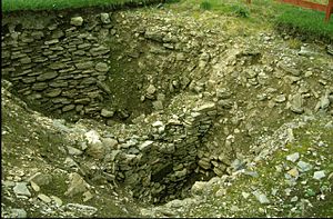
Mine Howe is a fascinating ancient site in Tankerness. It's a man-made underground chamber dug into a large mound of earth. The walls inside are carefully built with stones that form an arch. There are 29 steps that lead down to a rock floor.
Halfway down, the steps turn around, and more steps lead to a small chamber. This chamber is only about 1.3 meters (4 feet) wide but is over 4 meters (13 feet) tall! It has a special arched roof called a corbelled roof. A large ditch surrounds the mound. No one is completely sure what Mine Howe was used for, but it's believed to be from the Iron Age.
Other Ancient Sites
Near the Loch of Tankerness, you can find the ruins of an old building called the Howie of the Manse. It was once a broch, which is a type of ancient stone tower. Further east, at Taing of Beeman, there are remains of another ancient settlement.
In 1867, a very old woollen hood was found in the peat at nearby Groatsetter. This hood is thought to be from the late Iron Age. It might even be the oldest piece of fabric ever found in Britain!
Tankerness Through the Ages
Tankerness House and Its History
The Orkney Museum is located in Tankerness House in Kirkwall. This large town house was bought in 1641 by James Baikie of Tankerness. He was a successful merchant in Kirkwall and came from a family with a long history, including Paul Baikie, who was a navigator for a Norwegian king.
Hall of Tankerness
South of the Loch of Tankerness, you'll find the Hall of Tankerness. Today, it's a 19th-century farm building. However, it stands on the site of a much older building: the 12th-century drinking hall of Erling of Tankerness. Nearby, there's also an old pier that was once used by fishing boats, especially for herring.
World War II Defenses
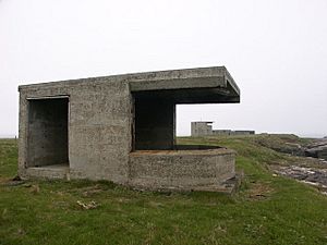
Rerwick Head was an important place during the Second World War. It was home to a military battery. You can still see concrete buildings there today. These buildings once held two large six-inch guns. These guns were taken from a famous battleship called HMS Iron Duke. Powerful searchlights helped the guns guard the waters leading to Shapinsay Sound.
Wildlife at Loch of Tankerness
The Loch of Tankerness is sometimes visited by a special type of bird called the Greenland white-fronted goose. In the 1960s, many of these geese, sometimes 50 to 100, would spend the winter there. However, their numbers have gone down a lot since the mid-1970s. This is probably because more land is being farmed, and there's more hunting in the area. Interestingly, as fewer geese visit Tankerness, more are seen on the island of Stronsay.
 | James Van Der Zee |
 | Alma Thomas |
 | Ellis Wilson |
 | Margaret Taylor-Burroughs |


