Pomponius Mela facts for kids
Pomponius Mela was an early Roman geographer. He wrote his books around 43 AD. He was born in a town called Tingentera (today Algeciras, Spain). He likely died around 45 AD.
His most famous work was a short book called De situ orbis libri III. (which means 'On the Location of the World, Book 3'). People used this book for almost 1500 years! It was a small book, less than 100 pages. The Encyclopædia Britannica (1911) said it was "dry in style" but had "pure Latin" and sometimes "pleasing word-pictures."
Mela's De situ orbis is the only complete book about geography from Classical Latin times. The only other similar writings are parts of Pliny the Elder's Historia naturalis. Pliny even mentioned Mela as an important source.
Contents
About Pomponius Mela
We do not know much about Pomponius Mela. We know his name and that he was from Tingentera. This town is now called Iulia Traducta and is in southern Spain, near Algeciras Bay.
We can guess when he wrote his book. He mentions a plan for the emperor to travel to Great Britain. This was most likely Claudius's plan in 43 AD to conquer Britain.
This passage cannot be about Julius Caesar. Mela mentions events from Augustus's time, like new names for Spanish towns. Many famous Romans, like the Senecas, Lucan, and Martial, came from Spanish communities. These communities later moved to Rome. Some people think Pomponius Mela might have been related to Marcus Annaeus Mela. Marcus Annaeus Mela was the son of Seneca the Elder and the father of Lucan.
Pomponius Mela's World View
Mela's ideas about geography were similar to those of Greek writers. These writers included Eratosthenes and Strabo. Mela probably did not know Strabo's work.
Mela was unique among ancient geographers. He divided the Earth into five zones. Only two of these zones could support life. He believed there were people called antichthones living in the southern zone. He thought people from the northern zone could not reach them. This was because of the extreme heat in the middle zone.
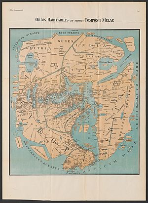
He followed Eratosthenes for the borders of Europe, Asia, and Africa. Like most ancient geographers, he thought the Caspian Sea was a part of the Northern Ocean. He believed it was like the Persian and Arabian (Red Sea) gulfs in the south.
Mela's understanding of India was not as good as some earlier Greek writers. He thought India was in the southeastern corner of Asia. From there, the coast went north to Scythia. Then it curved west towards the Caspian Sea. He also placed the Rhipaean Mountains and the Hyperboreans near the Scythian Ocean.
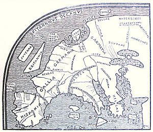
He knew more about western Europe. This was natural since he was from Spain, part of the Roman Empire. He described the western coast of Spain and Gaul (modern France) well. He also knew about the Bay of Biscay more accurately than Eratosthenes or Strabo. His ideas about the British Isles were also clearer than earlier writers. He was the first to name the Orcades, or Orkney Islands. He described their location quite correctly.
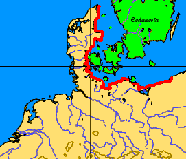
His knowledge of northern Europe was not perfect. But he spoke of a large bay called "Codanus sinus" north of Germany. Among its many islands was one, "Codanovia," which was very large. This name later appeared in Pliny the Elder's work as Scatinavia. Both Codanovia and Scatinavia were Latin versions of the Germanic name for Scandinavia.
How Mela Described the World
Mela described places by following ocean coasts. This style is called a periplus. It was probably based on stories from sailors. He started at the Straits of Gibraltar. Then he described the countries along the south coast of the Mediterranean Sea.
He then moved around Syria and Asia Minor to the Black Sea. After that, he returned to Spain along the north shore of the Black Sea and Propontis. After talking about the Mediterranean islands, he described the ocean coasts. He went west, north, east, and then south. This route went from Spain and Gaul around to India. From India, he went to Persia, Arabia, and Ethiopia. Finally, he worked his way back to Spain. Like most ancient geographers, he thought Africa was surrounded by sea and did not extend very far south.
Mela's Books and Translations
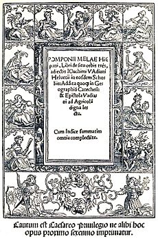
The first printed version of Mela's book was made in Milan in 1471. The first important scholarly edition was by Joachim Vadian in 1518. Later, other scholars like Johann Heinrich Voss and Johann Friedrich Gronovius made new editions. G. Paithey's edition from 1867 is known for its good text.
An English translation by Arthur Golding in 1585 was very famous. More recently, F. E. Romer published an English translation in 1998.
Sources
- Editions in the original Latin in the Internet Archive
- Books I, II and III in Latin, digitised at The Latin Library
- Attribution
See also
 In Spanish: Pomponio Mela para niños
 | William L. Dawson |
 | W. E. B. Du Bois |
 | Harry Belafonte |


