Red Sea facts for kids
Quick facts for kids Red Sea |
|
|---|---|
Map of the Red Sea
|
|
| Location | North Africa, East Africa, and West Asia |
| Coordinates | 22°N 38°E / 22°N 38°E |
| Type | Sea |
| Primary inflows | Gulf of Aden, Gulf of Suez |
| Primary outflows | Bab-el-Mandeb, Suez Canal |
| Basin countries | |
| Max. length | 2,250 km (1,400 mi) |
| Max. width | 355 km (221 mi) |
| Surface area | 438,000 km2 (169,000 sq mi) |
| Average depth | 490 m (1,610 ft) |
| Max. depth | 2,730 m (8,960 ft) |
| Water volume | 233,000 km3 (56,000 cu mi) |
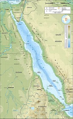
The Red Sea is a long, narrow body of water. It connects to the Indian Ocean in the south. This sea lies between the continents of Africa and Asia. In the south, it links to the ocean through the Bab-el-Mandeb Strait and the Gulf of Aden. To the north, you'll find the Sinai Peninsula, the Gulf of Aqaba, and the Gulf of Suez. The Gulf of Suez leads to the famous Suez Canal. The Red Sea sits on top of a giant crack in the Earth's crust. This crack is called the Red Sea Rift. It is part of the larger Great Rift Valley.
The Red Sea covers an area of about 438,000 km2 (169,000 sq mi). It stretches for about 2,250 km (1,400 mi) in length. At its widest point, it is about 355 km (221 mi) across. The average depth of the Red Sea is 490 m (1,610 ft). However, in one deep spot called the Suakin Trough, it reaches a maximum depth of 2,730 m (8,960 ft).
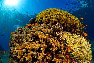
Much of the Red Sea is quite shallow. About 40% of its area is less than 100 m (330 ft) deep. Around 25% is even shallower, less than 50 m (160 ft) deep. These shallow areas are home to amazing marine life and beautiful corals. Over 1,000 different kinds of invertebrates live here. There are also more than 200 types of soft and hard corals. The Red Sea is the most northern tropical sea in the world. It is recognized as an important Global 200 ecoregion for its unique nature.
Contents
Why is it Called the Red Sea?
The name Red Sea comes from the Ancient Greek words Erythrà Thálassa. People have different ideas about why it's called "Red."
- Red Algae: One idea is that the name comes from tiny red-colored plants. These plants, called Trichodesmium erythraeum, sometimes bloom near the water's surface. When they bloom, they can make the sea look reddish.
- Directions: Another idea is that ancient languages used colors to mean directions. In this theory, "red" might have meant "south." This is similar to how the Black Sea's name might have meant "north."
- Ancient Stories: In the Hebrew Bible, the sea is called Yam Suph, which means "Sea of Reeds." This name is linked to the famous story of the Israelites crossing the sea.
The Red Sea is one of four seas in English named after colors. The others are the Black Sea, the White Sea, and the Yellow Sea.
A Look at the Red Sea's Past
Ancient Explorers and Trade Routes
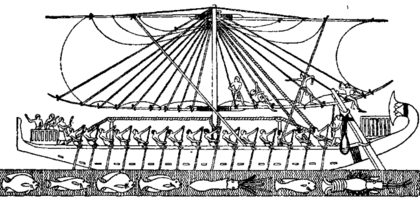
The first known explorations of the Red Sea were by ancient Egyptians. They wanted to find new trade routes to a place called Punt. One trip happened around 2500 BCE, and another around 1500 BCE by Queen Hatshepsut. Both were long journeys down the Red Sea.
The Hebrew Biblical Book of Exodus tells the story of the Israelites' crossing the Red Sea. The Hebrew text calls it Yam Suph. This name was traditionally thought to be the Red Sea.
Around 500 BCE, Darius the Great, a ruler of Persia, worked to make sailing in the Red Sea better. He sent teams to map the sea and find dangers like rocks. This helped make trade routes safer. During his rule, a canal was built to connect the Nile River to the northern Red Sea at Suez. This ancient canal helped trade and communication. It was a very early version of the modern Suez Canal.
Later, Alexander the Great sent Greek ships to explore the Red Sea and the Indian Ocean. Greek sailors gathered much information about the sea. A book called the Periplus of the Erythraean Sea, written around the 1st century, describes the Red Sea's ports and sea routes in detail.
The Red Sea became very important for Roman trade with India. This trade grew when the Roman Empire controlled the Mediterranean and northern Red Sea. Goods from China even reached the Roman world through this route.
Modern History and the Suez Canal
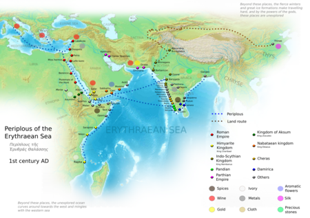
In the Middle Ages, the Red Sea was a key part of the spice trade route. In 1513, Portugal tried to control this important waterway. They sent a fleet, the first from Europe in modern times, to sail through the Bab al-Mandab strait.
In 1798, France tried to take control of the Red Sea by invading Egypt. Even though this mission failed, an engineer named Jean-Baptiste Lepère brought back the idea of building a canal. The Suez Canal finally opened in November 1869. This canal made it much faster to travel between Europe and Asia.
After the Second World War, more oil tankers used the Red Sea. However, the Six-Day War led to the Suez Canal closing from 1967 to 1975. Even after it reopened, the canal did not fully regain its top spot for shipping.
Recent Challenges in the Red Sea
Since late 2023, there have been attacks on commercial ships near the Bab al-Mandeb strait. These attacks have made the Red Sea a risky area for shipping. One ship was even hijacked. These events have caused serious environmental problems. They have also made global trade more difficult. Many shipping companies now send their vessels on longer routes around Africa. This increases fuel use and pollution. Countries have sent naval forces to help protect ships in the Red Sea.
How the Red Sea Works
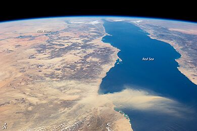
The Red Sea is surrounded by dry lands, deserts, and semi-deserts. Many parts of its coast have healthy coral reefs. These reefs are some of the best in the world. This is because there are not many people living nearby and the currents help keep the water clean. The Red Sea exchanges water with the Arabian Sea and Indian Ocean. This helps balance the high saltiness from evaporation.
The Red Sea's climate is shaped by two monsoon seasons. These winds happen because land and sea heat up differently. The sea has very high surface temperatures and is very salty. This makes it one of the warmest and saltiest seas on Earth. In summer, the surface water can be 26 °C (79 °F) in the north and 30 °C (86 °F) in the south. In winter, it only changes by about 2 °C (3.6 °F). The average water temperature is 22 °C (72 °F). The water is usually very clear, with visibility up to 200 m (660 ft).
The Red Sea and its coasts get very little rainfall, about 60 mm (2.36 in) each year. This lack of fresh water and high evaporation makes the sea very salty. Scientists have found that even with extreme heat, the corals in some areas are healthy. They have very little coral bleaching. This is a good sign for the future of corals.
Salty Waters
The Red Sea is one of the saltiest bodies of water in the world. This is because of high evaporation and very little rain. No large rivers flow into it. Also, its connection to the Gulf of Aden is narrow. Its salinity (saltiness) ranges from about 36 parts per thousand in the south to 41 parts per thousand in the north. The average is 40 parts per thousand. This is much saltier than the world's average seawater, which is about 35 parts per thousand.
Ocean Currents and Winds
Currents in the Red Sea are usually weak and change often. They are mostly controlled by the wind. In summer, northwesterly winds push surface water south. In winter, the flow reverses, bringing water from the Gulf of Aden into the Red Sea.
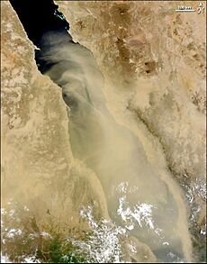
The northern Red Sea has strong, steady north-west winds. These winds can reach speeds of 7 km/h (4.3 mph) to 12 km/h (7.5 mph). Winds are very important in the Red Sea. They move sediments and help shape the coast.
How the Red Sea Was Formed
The Red Sea was formed when the Arabian Peninsula pulled away from the Horn of Africa. This process started millions of years ago and is still happening today. The sea is slowly getting wider. Scientists believe it might become an ocean in the future.
Deep under the Red Sea, there are very hot, salty pools of water called brines. These brines come from cracks in the seafloor. The high saltiness of these waters means very few living things can survive there.
The Red Sea also has several volcanic islands. Most of these volcanoes are not active. However, some new islands have formed recently. For example, in 2011 and 2013, two new islands appeared in the Zubair Archipelago near Yemen.
Amazing Animals of the Red Sea
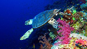
The Red Sea is home to a rich and diverse world of animals. More than 1,200 types of fish live here. About 10% of these fish are found nowhere else on Earth!
Since the Suez Canal opened in 1869, many marine species from the Red Sea have moved into the Mediterranean Sea. This includes plankton, seaweeds, invertebrates, and fish. These new species are now an important part of the Mediterranean ecosystem.
The amazing variety of life in the Red Sea is partly due to its long coral reefs. These reefs stretch for 2,000 km (1,240 mi) along the coastline. They are 5,000 to 7,000 years old. They are mostly made of stony corals. These reefs create platforms and lagoons along the coast.
The Red Sea also has many reefs further out at sea. Many of these reefs are unusual because of the high amount of tectonic activity in the area. Both coastal and offshore reefs are visited by large ocean fish, including many of the 44 types of shark found here. There are also over 175 types of nudibranchs, many of which are unique to the Red Sea. Other habitats include seagrass beds, mangroves, and salt marshes.
The Egyptian government recognized this rich biodiversity. They created the Ras Mohammed National Park in 1983. This park helps protect the local marine life. Ras Mohammed is one of the top 10 sites in the world for managing marine ecosystems.
The Red Sea is a very busy shipping route. This means it is at risk from pollution, especially oil spills. Scientists are studying how spills affect coral reefs and marine life. They also look at how chemicals used to clean spills impact the environment.
Crabs
- Hairy elbow crab
- Rusty guard crab
- Brown guard crab
- Indo-Pacific hairy hermit crab
- Grapsus granulosus
- Furrowed crab
- Tiny rock crab
- Soft coral spider crab
- Purple estuarine rock crab
- One-horned spider crab
- Soft coral crab
- Scaly rock crab
- Haig's porcelain crab
- Violet crab
- Ornamental spider crab
- Xenia swimming crab
- Reticulated hermit crab
- Showy xanthid crab
- Giant elbow crab
- White-handed fiddler crab
- Woodmason's hermit crab
- Inversed fiddler crab
- African blue swimming crab
- Rosy hermit crab
- Tetralia nigrolineata
- Setiferous hermit crab
- Hairy coral crab
Sea Turtles
Dolphins
- Spinner dolphin
- Indo-Pacific bottlenose dolphin
- Common bottlenose dolphin
- Indian humpback dolphin
- Risso's dolphin
- Pantropical spotted dolphin
Fish
- Lyretail anthias (a very common fish)
- Red Sea anemonefish
- Indian lionfish
- Klunzinger's wrasse
- Indian bullethead parrotfish
- Sohal tang
- Red Sea bannerfish
- Masked pufferfish
- Raccoon butterflyfish
- Sergeant major
- Giant moray eel
- Arabian Picasso triggerfish
- Rusty parrotfish
- White-spotted pufferfish
- Threadfin butterflyfish
- Lined bristletooth
- Bluespotted cornetfish
- Purple tang
- Coral grouper
- Crown butterflyfish
- Red Sea goatfish
- Indian Ocean humbug
- Titan triggerfish
- Yellow boxfish
- Threespot dascyllus
- Orangestripe triggerfish
- Emperor angelfish
- Yellow-edged lyretail
- Dusky surgeonfish
- Starry pufferfish
- Greasy rockrod grouper
- Napoleon fish
- Geometric moray eel
- Sharksucker (also called a remora)
- Golden-striped mackerel
- Great barracuda
- Panther flounder
- Doublebar bream
- Giant trevally
- Zigzag wrasse
- Dogtooth tuna
- Needlefish (Houndfish)
- Black-barred halfbeak
- Red Sea garden eel
- Smallscale scorpionfish
- Fringelip mullet
- Flathead pomfret
- Yellowfin tuna
- Mahi-mahi
Jellyfish and Cnidarians
- Cauliflower jellyfish
- Mangrove upside-down jelly
- Amakusa jelly
- Pelagic purple jelly
- Nomad jellyfish
- Moon jellyfish
Sharks
- Tawny nurse shark
- Whale shark
- Tiger shark
- Whitetip reef shark
- Great hammerhead
- Blacktip reef shark
- Gray reef shark
- Pelagic thresher shark
- Spinner shark
- Silky shark
- Oceanic whitetip shark
- Spot-tail shark
- Longfin mako shark
- Sicklefin lemon shark
- Shortfin mako shark
- Zebra shark
- Bull shark
- Great white shark (very rare)
Billfish
Octopuses and Other Cephalopods
- Day octopus
- Ornate night octopus
- Mimic octopus
- Marbled octopus
- Red Sea long-arm octopus
- Giant squid
Rays
- Cowtail stingray
- Porcupine ray
- Ornate eagle ray
- Reticulate whipray
- Sicklefin devil ray
- Bluespotted fantail ray
- Oceanic manta ray
Lobsters
- Pronghorn spiny lobster
- Painted spiny lobster
Whales
- False killer whale (one was seen off Saudi Arabia in December 2024)
- Pygmy blue whale
- Bryde's whale (one was found in Al-Qunfudah)
- Blue whale (one was seen in the Gulf of Aqaba in 2018)
- Sperm whale
- Humpback whale (rarely seen, as they enter the ocean through the Bab Al-Mandeb strait)
Environmental Concerns
Since late 2023, attacks on ships in the Red Sea have created serious environmental risks.
Pollution from Spills
When ships are damaged, they can spill oil and chemicals into the sea. For example, the sinking of the MV Rubymar in February 2024 caused an 18-mile oil slick. It also carried fertilizers, which could lead to harmful algal blooms and kill fish. These spills threaten marine life, including precious coral reefs, and coastal communities. Other attacks have also caused oil slicks, harming the environment.
More Emissions from Longer Routes
Many shipping companies are now sending their ships around Africa instead of through the Suez Canal. This makes journeys 50-60 percent longer. These longer routes mean ships use more fuel, leading to a big increase in CO₂ emissions. This makes it harder to reach global climate goals.
Harm to Marine Life
The increase in shipping traffic around Africa also causes more underwater noise pollution. This noise can harm local fish and marine mammals. Military operations in the Red Sea use sonar systems. These can disturb marine life, especially cetacean species like dolphins and whales, who rely on sound to navigate and communicate. Also, naval mines used in the sea pose risks to marine ecosystems.
Challenges for Conservation
The Red Sea region does not have a strong, overall environmental agreement to protect it. Protecting the environment is harder during times of conflict. It is difficult for countries to work together to clean up spills or monitor pollution when there are ongoing security issues.
Desalination Plants
Many people and industries along the Red Sea need fresh water. To get it, they use desalination plants. These plants remove salt from seawater. However, they also discharge warm, salty water and chemicals back into the sea. This can harm and kill corals and cause diseases in fish. While this impact is currently local, it could grow and affect the fishing industry.
Trade and Tourism
Global Trade Route
The Red Sea is very important for the global economy. Cargo ships travel between the Indian Ocean and the Mediterranean Sea every year. This route, through the Suez Canal, cuts the journey between Asia and Europe almost in half. About 12% of all global trade passes through the Red Sea. This includes 30% of the world's container traffic.
Fun for Tourists
The Red Sea is famous for its recreational diving spots. Places like Ras Mohammed and Elphinstone Reef in Egypt are popular. There are also great sites in Sudan. Many people visit the Red Sea to see its amazing underwater world.
Popular tourist towns include El Gouna, Hurghada, and Sharm El Sheikh in Egypt. Aqaba in Jordan and Eilat in Israel are also well-known. These areas are sometimes called the Red Sea Riviera.
Safety is very important in tourist areas. For example, in 2010, a beach in Sharm el-Sheikh was closed due to shark attacks. Scientists investigated to understand why this happened. They looked at things like overfishing and how tourist boats might attract sharks. The Red Sea Project in Saudi Arabia is also building new resorts to welcome more visitors.
Countries Around the Red Sea
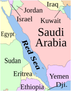
The Red Sea can be divided into three parts: the main Red Sea, and in the north, the Gulf of Aqaba and the Gulf of Suez. The six countries that border the main Red Sea are:
The Gulf of Suez is entirely bordered by Egypt. The Gulf of Aqaba borders Egypt, Israel, Jordan, and Saudi Arabia.
Towns and Cities
Here are some towns and cities along the Red Sea coast (including the Gulfs of Aqaba and Suez):
- Ain Sokhna, Egypt (العين السخنة)
- Al Hudaydah, Yemen (الحديدة)
- Al Lith, Saudi Arabia (الليِّث)
- Al Qunfudhah, Saudi Arabia (القنفذة)
- Al-Qusair, Egypt (القصير)
- Al Wajh, Saudi Arabia (الوجه)
- Aqaba, Jordan (العقبة)
- Asseb, Eritrea (ዓሰብ / عصب)
- Dahab, Egypt (دهب)
- Duba, Saudi Arabia (ضباء)
- Eilat, Israel (אילת)
- El Gouna, Egypt (الجونة)
- El Tor, Egypt (الطور)
- Suez, Egypt (السويس)
- Hala'ib, Egypt and Sudan (حلايب) (disputed)
- Haql, Saudi Arabia (حقل)
- Hirgigo, Eritrea (ሕርጊጎ / حرقيقو)
- Hurghada, Egypt (الغردقة)
- Jeddah, Saudi Arabia (جدة)
- Jazan, Saudi Arabia (جازان)
- Marsa Alam, Egypt (مرسى علم)
- Massawa, Eritrea (ምጽዋዕ / مصوع)
- Mokha, Yemen (المُخا)
- Moulhoule, Djibouti (مول هولة)
- Nuweiba, Egypt (نويبع)
- Port Sudan, Sudan (بورت سودان)
- Rabigh, Saudi Arabia (رابغ)
- Safaga, Egypt (سفاجا)
- Sharm El Sheikh, Egypt (شرم الشيخ)
- Soma Bay, Egypt (سوما باي)
- Suakin, Sudan (سواكن)
- Taba, Egypt (طابا)
- Thuwal, Saudi Arabia (ثول)
- Yanbu, Saudi Arabia (ينبع)
See also
 In Spanish: Mar Rojo para niños
 | Anna J. Cooper |
 | Mary McLeod Bethune |
 | Lillie Mae Bradford |


