
Suez facts for kids
Quick facts for kids
Suez
السويس
|
||
|---|---|---|
    |
||
|
||

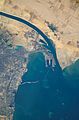
Satellite view of the port and city, the southern terminus of the Suez Canal that transits through Egypt and debouches into the Mediterranean Sea near Port Said. (Up is north-east).
|
||

Suez
Location in Egypt

Suez
Location in Lower Egypt

Suez
Location in Africa
|
||
| Country | Egypt | |
| Governorate | Suez | |
| Founded | 1859 | |
| Area | ||
| • Total | 9,002 km2 (3,476 sq mi) | |
| Elevation | 11 m (36 ft) | |
| Population
(2021)
|
||
| • Total | 801,894 | |
| • Density | 89.080/km2 (230.715/sq mi) | |
| GDP | ||
| • Total | EGP 119 billion (US$ 7.6 billion) |
|
| Time zone | UTC+3 (EGY) | |
| Website | Suez.gov.eg | |

Suez (pronounced esse-WEES) is a big seaport city in north-eastern Egypt. About 700,000 people live there. It is located on the northern coast of the Gulf of Suez, which is part of the Red Sea. The city is also very close to the southern end of the famous Suez Canal. Suez is the capital city of the Suez Governorate.
The city has three important ports: Suez Port (also called Port Tewfik), al-Adabiya, and al-Zaytiya. These ports have many facilities for ships. Together, these areas form a large metropolitan area (a big city and its surrounding towns). Most of Suez is in Africa, but a small part is in Asia.
Railway lines and highways connect Suez to other major Egyptian cities like Cairo, Port Said, and Ismailia. Suez is an industrial city. It has a factory that makes petrochemicals (products from oil and natural gas). Its oil refineries (places where crude oil is turned into useful products) send finished products to Cairo through pipelines. The flag of the Suez Governorate shows these important features: the blue color represents the sea, a gear symbolizes industry, and a flame stands for the oil companies.
The modern city of Suez was built near an older city called Clysma. Clysma was once a very important port on the Red Sea.
Contents
What Does the Name "Suez" Mean?
The name of the city, Suez, comes from an Arabic word. It is a smaller form of the Arabic word for 'liquorice'.
A Look Back in Time: The History of Suez
Suez has a long and interesting history, especially because of its location near important waterways.
Ancient Times: The Achaemenid Empire
Long ago, during the time of the Achaemenid Empire, a powerful Persian empire, there were special writings known as Darius the Great's Suez Inscriptions. These texts were carved on five monuments in a place called Wadi Tumilat. They were written in several ancient languages, including Old Persian and Egyptian.
The inscriptions celebrated the opening of a canal. This canal connected the Nile River to the Bitter Lakes, which helped ships travel between Egypt and Persia. Egypt was then a part of the Achaemenid Empire.
What Did the Suez Inscriptions Say?
One part of the Old Persian text from these inscriptions translates to:
"King Darius says: I am a Persian; setting out from Persia I conquered Egypt. I ordered to dig this canal from the river that is called Nile and flows in Egypt, to the sea that begins in Persia. Therefore, when this canal had been dug as I had ordered, ships went from Egypt through this canal to Persia, as I had intended."
This shows how important this ancient canal was for trade and travel.
Early Islamic Era: Kolzum and Suez
In the 600s AD, a town called "Kolzum" existed just north of where Suez is today. Kolzum was the eastern end of a canal built by Amr ibn al-'As. This canal linked the Nile River and the Red Sea.
Kolzum's trade suffered when the canal was closed in 770 AD. This was done by the second Abbasid ruler, al-Mansur, to stop his enemies in Arabia from getting supplies from Egypt. However, the town still benefited from trade between Egypt and Arabia. Later, in 780 AD, al-Mansur's successor al-Mahdi reopened part of the canal.
In 971 AD, a group called the Qarmatians captured Kolzum. The Arab traveler al-Muqaddasi, who visited in 986 AD, noted that Suez was nearby and provided drinking water for Kolzum.
The Ayyubid ruler of Egypt, Saladin, made both Kolzum and Suez stronger. He wanted to protect Egypt from attacks by Crusaders. Between 1183 and 1184, a Crusader leader named Raynald of Chatillon tried to stop the Ayyubid soldiers in Kolzum from getting water. Saladin's brother, al-Adil, built a navy to stop Raynald.
By the 1200s, Kolzum was in ruins. Suez slowly took its place as the main town. Historians say Kolzum was once rich but was later attacked by Bedouins.
Ottoman and Egyptian Rule
._Plan_du_port_de_Soueys_et_du_fond_du_Golfe_Arabique._I-IV._Profils_du_canal_projet%C3%A9_entre_les_deux_mers_(NYPL_b14212718-1268722).jpg)
To protect Egyptian towns and the port of Jeddah from Portuguese attacks, the last Mamluk ruler, Qansuh al-Ghawri, sent 6,000 soldiers to defend Suez in 1507.
After the Ottomans took over Egypt in the early 1500s, Suez became a very important naval base and trading center. The Ottoman navy in Suez played a key role in controlling trade in the Indian Ocean against the Portuguese.
Portuguese Attacks on Suez
In 1541, a Portuguese fleet tried to attack Suez to weaken the Ottoman navy. However, the Ottomans knew they were coming. The Portuguese fleet spent seven months in the Red Sea but could not find and fight the Ottoman ships.
By the time the French invasion of Egypt and Syria happened in 1798, Suez had become a small, less important town again. Fighting between French and Ottoman soldiers in 1800 destroyed most of the city. However, Suez became very important once more after the Suez Canal opened in 1869.
Modern Era: Challenges and Growth
Suez was almost completely destroyed during battles in the late 1960s and early 1970s. These battles were between Egyptian and Israeli forces who were occupying the Sinai Peninsula. The city was empty after the Six-Day War in 1967.
An Israeli attempt to capture the city failed, with significant losses for the Israeli army. Suez began to be rebuilt soon after Egypt reopened the Suez Canal, following the Yom Kippur War with Israel.
Suez was the first city where large protests took place against the government of Hosni Mubarak during the 2011 Egyptian revolution. It was also where the first person died in that uprising. Because of this, Suez has been compared to Sidi Bouzid, a small town in Tunisia that played a similar role in the 2010–2011 Tunisian revolution.

In March 2021, a huge container ship called the Ever Given got stuck across the Suez Canal near the city. This event, known as the 2021 Suez Canal obstruction, blocked traffic for several days.
Exploring the City: Suez Districts
The city of Suez is divided into five main areas, each with its own unique features.
El Arbaeen District

This is the most populated part of Suez. Many government buildings and public offices are located here. It also has the city's main markets for fruits and vegetables, along with many other shops.
Suez District

Suez District is considered the wealthiest area in the city. Property here is much more expensive than in other districts. The buildings have a more modern look compared to those in El Arbaeen.
This district includes the rich neighborhood of Port Tawfik, which has direct views of the Suez Canal. Port Tawfik also has some old-style houses from the time when the English were present in Egypt. Two of Egypt's most important oil refineries, El-Nasr Petroleum Company and Suez Petroleum Company, are in this district. Also, Suez Port, one of Egypt's main ports, is located here.
El Ganayen District
This district stretches all the way to the border with Ismailia Governorate. It contains all the parts of the city that are in Asia. This area is mostly rural, like the "countryside" of Suez.
Faisal District
This district has many of the city's newer neighborhoods. Most of the areas in Faisal District were built after the 1973 Yom Kippur War, which caused a lot of damage to the city. Some neighborhoods here include Al-Sabbah, Al-Amal, and Al-Mushi.
Ataqah District
This district is known for its many industrial areas. You can find plants and factories that make things like fertilizers, cement, steel, cooking oil, and ceramic tiles. The Attaka Power Plant is also located here.
Ataqah District also includes Ain Sokhna, a very important sea resort in Egypt. It is on the Gulf of Suez and has many fancy resorts. Many tourists, both Egyptian and foreign, visit Ain Sokhna all year because of its warm weather. The Ain Sokhna Sea Port, operated by DP World, and the Al-Ataka Fishing Port, which is the city's main fishing port, are also in this district.
The Famous Suez Canal


_07.jpg)

In ancient times, there was a canal connecting the Nile delta to the Gulf of Suez. This old canal eventually stopped being used. The current Suez Canal was built in the 1800s.

The Suez Canal makes sea travel much shorter for ships. Before it was built, ships had to sail all the way around the Cape of Good Hope in southern Africa. Building the canal was made easier by the natural features of the area. The distance between the Mediterranean Sea and the Red Sea is not very long. Also, there are natural lakes and low areas along the route, like Lake Manzala and the Bitter Lakes. The land is also mostly flat.
The idea for the canal came from a French engineer and diplomat named Ferdinand de Lesseps. In 1854, he got permission from Said Pasha to build and operate the canal for 99 years. The company Compagnie Universelle du Canal Maritime de Suez was created. It took 11 years to build the canal, and it officially opened on November 17, 1869. The canal immediately had a huge impact on world trade.
In July 1956, the Egyptian government, led by President Gamal Abdel Nasser, took control of the Suez Canal Company. This company had been run by the French and was privately owned, with the British being the biggest shareholders. This event led to the Suez Crisis in 1956, when Israeli, British, and French forces invaded the Suez Canal area.
After Israel invaded and occupied the Sinai Peninsula in the Six-Day War of 1967, the Canal was closed. It did not reopen until 1975.
On March 23, 2021, a large container ship called the Ever Given got stuck in the canal, blocking it for several days.
Today, the Suez Canal is a very important part of world trade. It also brings a lot of money to the Egyptian economy. In 2009, the money earned from the canal made up 3.7% of Egypt's total economic output (GDP).
Geography of Suez

The Isthmus of Suez is a narrow strip of land that is considered the border between the continents of Africa and Asia.
Climate in Suez
Suez has a hot desert climate. This means it is very hot and dry.
The hottest temperature ever recorded in Suez was 49°C (120.2°F) on June 14, 1965. The coldest temperature recorded was 1°C (33.8°F) on February 23, 2004.
| Climate data for Suez (1961–1990) | |||||||||||||
|---|---|---|---|---|---|---|---|---|---|---|---|---|---|
| Month | Jan | Feb | Mar | Apr | May | Jun | Jul | Aug | Sep | Oct | Nov | Dec | Year |
| Record high °C (°F) | 29.4 (84.9) |
39.0 (102.2) |
36.9 (98.4) |
42.8 (109.0) |
43.5 (110.3) |
46.1 (115.0) |
44.1 (111.4) |
45.8 (114.4) |
41.2 (106.2) |
39.2 (102.6) |
37.0 (98.6) |
28.4 (83.1) |
46.1 (115.0) |
| Mean daily maximum °C (°F) | 19.4 (66.9) |
21.2 (70.2) |
23.6 (74.5) |
28.5 (83.3) |
32.4 (90.3) |
35.1 (95.2) |
36.1 (97.0) |
35.7 (96.3) |
33.2 (91.8) |
30.1 (86.2) |
25.4 (77.7) |
20.7 (69.3) |
28.4 (83.1) |
| Daily mean °C (°F) | 14.8 (58.6) |
16.0 (60.8) |
18.2 (64.8) |
22.3 (72.1) |
25.7 (78.3) |
28.1 (82.6) |
29.3 (84.7) |
29.3 (84.7) |
27.3 (81.1) |
24.5 (76.1) |
20.2 (68.4) |
16.0 (60.8) |
22.6 (72.7) |
| Mean daily minimum °C (°F) | 10.5 (50.9) |
11.3 (52.3) |
13.1 (55.6) |
16.4 (61.5) |
19.5 (67.1) |
22.4 (72.3) |
23.9 (75.0) |
24.2 (75.6) |
22.8 (73.0) |
20.0 (68.0) |
15.7 (60.3) |
11.8 (53.2) |
17.6 (63.7) |
| Record low °C (°F) | 4.1 (39.4) |
5.6 (42.1) |
7.4 (45.3) |
8.7 (47.7) |
13.6 (56.5) |
17.7 (63.9) |
19.4 (66.9) |
19.7 (67.5) |
16.9 (62.4) |
14.5 (58.1) |
9.9 (49.8) |
5.5 (41.9) |
4.1 (39.4) |
| Average precipitation mm (inches) | 5 (0.2) |
2 (0.1) |
4 (0.2) |
1 (0.0) |
0 (0) |
0 (0) |
0 (0) |
0 (0) |
0 (0) |
0 (0) |
2 (0.1) |
3 (0.1) |
17 (0.7) |
| Average precipitation days (≥ 1.0 mm) | 0.6 | 0.1 | 0.5 | 0.1 | 0.0 | 0.0 | 0.0 | 0.0 | 0.0 | 0.0 | 0.1 | 0.3 | 1.7 |
| Average relative humidity (%) | 58 | 56 | 53 | 45 | 44 | 47 | 52 | 54 | 55 | 57 | 58 | 60 | 53 |
| Average dew point °C (°F) | 6.2 (43.2) |
6.5 (43.7) |
7.6 (45.7) |
9.4 (48.9) |
11.4 (52.5) |
15.4 (59.7) |
17.8 (64.0) |
18.6 (65.5) |
17.3 (63.1) |
15.3 (59.5) |
11.4 (52.5) |
8.1 (46.6) |
12.1 (53.8) |
| Source: NOAA | |||||||||||||
Twin Cities: Suez Around the World
Suez has "twin" or "sister" cities, which means they have special friendly relationships:
Famous People from Suez
- Ismail Yassine (1912-1972), a well-known singer, comedian, and actor.
- Ebrahim Nafae (1934–2018), a journalist and former editor-in-chief of the Al-Ahram Newspaper.
- Abdel Latif Moubarak (born 1964), a poet.
- Youssef Maaty (born 1963), a playwright (someone who writes plays).
Images for kids
-
Satellite view of the port and city, the southern terminus of the Suez Canal that transits through Egypt and debouches into the Mediterranean Sea near Port Said. (Up is north-east).
See also
 In Spanish: Suez para niños
