
Shapinsay facts for kids
| Norse name | Hjálpandisey |
|---|---|
| Meaning of name | Old Norse for 'helpful island' or 'judge's island' |
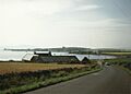
 Cannon decorate the quayside of Balfour Harbour on Shapinsay, the round tower in the background is The Douche |
|
| OS grid reference | HY505179 |
| Coordinates | 59°03′N 2°53′W / 59.05°N 2.88°W |
| Physical geography | |
| Island group | Orkney |
| Area | 2,948 hectares (11.4 sq mi) |
| Area rank | 29 |
| Highest elevation | Ward Hill 64 metres (210 ft) |
| Administration | |
| Sovereign state | United Kingdom |
| Country | Scotland |
| Council area | Orkney Islands |
| Demographics | |
| Population | 307 |
| Population density | 10.4 people/km2 |
| Largest settlement | Balfour |
Shapinsay (Scots: Shapinsee) is one of the Orkney Islands. These islands are located off the north coast of mainland Scotland. The island has one village called Balfour. From Balfour, you can catch car ferries to Kirkwall on the Orkney Mainland.
Balfour Castle is a very noticeable building on the island. It was built in the Scottish Baronial style. The castle reminds us of the Balfour family, who were very important on Shapinsay in the 1700s and 1800s. They changed farming on the island by bringing in new ways to grow crops. Other interesting places on Shapinsay include old standing stones, an Iron Age broch, and a special salt-water shower building.
Shapinsay is about 29.5 square kilometres (11.4 sq mi) in size. This makes it the eighth largest island in the Orkney group. The island is mostly flat and has rich soil, so much of it is used for farming. Shapinsay also has two nature reserves and is well-known for its many different birds.
In 2011, about 307 people lived on Shapinsay. The island's economy mainly relies on farming. There are also a few small businesses, mostly for tourists. People are also thinking about building a wind turbine on the island.
Contents
- What Does the Name Shapinsay Mean?
- A Look Back: Shapinsay's History
- Where is Shapinsay?
- What is Shapinsay's Geology Like?
- Animals and Plants of Shapinsay
- How Many People Live on Shapinsay?
- Famous Buildings on Shapinsay
- How Does Shapinsay Make Money?
- Education and Culture on Shapinsay
- Shapinsay's Folklore and Legends
- Images for kids
- See also
What Does the Name Shapinsay Mean?
The name 'Shapinsay' is a bit of a mystery, unlike many other large Orkney islands. The end part, 'ay', comes from the Old Norse word for island. But the first part is harder to figure out.
Some people think it comes from hjalpandis-øy, which means helpful island. This might be because the island has a good harbour. Another idea is that it comes from Judge's island. The oldest written record from 1375 calls it Scalpandisay, which could support this idea.
A Look Back: Shapinsay's History
Early Times on Shapinsay

Old standing stones show that people have lived on Shapinsay since the Neolithic (New Stone Age) period. A Roman general named Agricola took control of the Orkney Islands, according to an ancient writer named Tacitus. There's a local story that Agricola himself landed on Shapinsay. In the 1700s, a farm called Grukalty was even renamed Agricola. Roman coins have been found on the island, but traders might have brought them there.
Shapinsay is also mentioned briefly in the old Norse sagas. The Saga of Haakon Haakonsson says that Haakon IV of Norway stopped in Elwick Bay. He was on his way south before losing a battle at Largs.
Changes in the 1700s

The 1700s marked the start of big changes in farming on Shapinsay. This was thanks to the Balfour family. They owned the Sound estate, which covered the western part of the island. In 1674, Arthur Buchanan built the house of Sound, where Balfour Castle stands today.
Later, Thomas Balfour bought the estate in 1782. He had to sell his army job and borrow money to do this. Once on the island, he built a new house called Cliffdale. He also started the village of Shoreside, which is now known as Balfour. Thomas Balfour also improved farming by fencing off fields and building farmhouses.
William Irving was born around 1740 in a small village called Quholm on the island. He became a sailor and then moved to New York in 1763. His son was Washington Irving, who wrote famous stories like Rip van Winkle. Washington Irving was the first American writer to become famous around the world.
Marjory Meason, from Shapinsay, was the last person executed in Orkney in 1728.
During this time, burning kelp (seaweed) was very important for the island's economy. People made soda ash from the burned seaweed. This brought a lot of money to the islanders. For Thomas Balfour, kelp farming made four times more money than regular farming.
The 1800s: Big Transformations

The 1800s brought even bigger changes to Shapinsay. Thomas Balfour's grandson, David Balfour, changed the island a lot. By 1846, his family owned all of Shapinsay. Most of the land was divided into fields of 4 hectares (10 acres). This layout can still be seen today.
Farmers had to fence and drain their land. If they didn't, the estate would do it and add the cost to their rent. In 1846, about 303 hectares (1.17 sq mi) of Shapinsay was farmland. By 1860, this had grown to over 890.3 hectares (3.44 sq mi). New crops and different types of cattle and sheep were also brought in. David Balfour's changes were seen as the start of improvements across Orkney.
Balfour also gave the island its most famous building: Balfour Castle. He hired an architect, David Bryce, to turn Cliffdale House into the grand castle. He also built other important structures. These included the porter's lodge (now a public house called The Gatehouse), a water mill, a school, and a gasworks. The gasworks worked until the 1920s. It looks like a round tower and was built to make the village look like a medieval town. David Balfour also built Mill Dam, which was a water supply for the mill. Today, it's an RSPB nature reserve.
Fishing for herring and cod also became more important in the 1800s. By the middle of the century, Shapinsay had 50 herring boats. Cod fishing grew because wars made English fishing boats go further north. Local fishermen started using trawling methods. However, fishing was often a part-time job for islanders. A saying from that time was: "a Shetlander is a fisherman with a croft, while an Orcadian is a farmer with a boat."
The kelp industry ended by 1830. This happened because cheaper ways to make soda ash were found in Europe. This collapse encouraged farmers to focus more on agriculture.
The 1900s: Modern Times

The Balfour estate sold its farms on Shapinsay between 1924 and 1928. This was common in Orkney as rich landowners looked for other ways to invest their money. Farms were usually sold to the people already farming them or to their neighbors.
Farming on Shapinsay changed a lot in the 1900s. Machines became common, especially after the Second World War. More land was used for growing grass. Growing grain (except for barley) and turnips became less common. These were replaced by silage for winter animal food.
Orkney was an important place during both World Wars. Shapinsay had gun batteries built on it. During the First World War in 1917, a ship called the Swiftsure sank near the island. In the Second World War, gun batteries protected the Wide Firth from German torpedo boats. Mains electricity came to Shapinsay in the 1970s through an underwater cable from Kirkwall.
Towards the end of the century, farming started to become more environmentally friendly. This was helped by government and European Union grants. For example, the largest farm on the island, Balfour Mains, started to focus on natural plants and nesting birds. They limited grazing and used fewer chemical fertilizers.
Tourism also started to become important in the second half of the 1900s. The first restaurant with bed and breakfast rooms opened in 1980.
Where is Shapinsay?


Shapinsay covers an area of 2,948 hectares (11 sq mi). It is the 8th largest Orkney island and the 29th largest Scottish island. The highest point is Ward Hill, which is 64 metres (210 ft) above sea level. The east coast has low cliffs and several sea caves. One beautiful cave is called Geo of Ork at the very north end. Elwick Bay is a safe place for boats on the south coast, facing the Orkney mainland. The main village, Balfour, is at the west end of this bay.
The island has several ayres. These are narrow strips of shingle or sand that cut across shallow bays. Sometimes they can cut off a body of water from the sea, forming shallow freshwater lochs called oyces. Examples include Vasa Loch and Lairo Water.
There are also small islands nearby. These include Broad Shoal, Grass Holm, and Skerry of Vasa. Helliar Holm is a tidal islet at the eastern entrance to Balfour harbour. It has a small lighthouse and the remains of an old broch. The String, a stretch of water between Helliar Holm and the mainland, has strong tidal currents.
What is Shapinsay's Geology Like?

Like most of the Orkney islands, Shapinsay's main rock is Old Red Sandstone. This rock is about 400 million years old. It formed when older rocks eroded and were deposited into river deltas. A large freshwater lake, called Lake Orcadie, existed at the edges of these eroding mountains.
Most of Shapinsay is made of Rousay flagstone. This rock formed in the Lower Middle Devonian period. Some Eday flagstone is found in the southeast, which formed in wetter conditions later on. Eday flagstone is considered better for building. At Haco's Ness, in the southeast, there is a small area of a different type of rock called diabase. The island is covered with a rich layer of clay. This clay formed during the Pleistocene ice ages.
Animals and Plants of Shapinsay

The island is home to many birds, especially wading birds like curlews and redshank. You can find them at The Ouse and Veantro Bay. There are also many gull and tern colonies on the rocky shores and cliffs. Pintails, shovelers, and whooper swans visit regularly in summer. You can also find shelducks, hen harriers, and Arctic skuas breeding here. There are also red-legged partridges that were brought to the island.
Otters can be seen at The Ouse, Lairo Water, and Vasa Loch. You can also spot common seals and Atlantic grey seals around the coast. There are plans to build a special place for visitors to watch seals without disturbing them. Shapinsay and Hoy are the only two larger Orkney islands that do not have the Orkney vole.
In summer, many wildflowers grow on the island. A special type of lichen called Melaspilea interjecta is found in only three places in Scotland, and Shapinsay is one of them. Besides the RSPB reserve at Mill Dam, there is also a Scottish Wildlife Trust reserve at East Hill in the southeast.
How Many People Live on Shapinsay?
| Year | Pop. | Year | Pop. |
|---|---|---|---|
| 1798 | 730 | 1911 | 718 |
| 1841 | 935 | 1921 | 624 |
| 1851 | 899 | 1931 | 584 |
| 1861 | 973 | 1951 | 487 |
| 1871 | 949 | 1961 | 346 |
| 1881 | 974 | 1981 | 345 |
| 1891 | 903 | 1991 | 322 |
| 1901 | 769 | 2001 | 300 |
| 2011 | 307 |
The most people ever recorded living on Shapinsay was 974 in 1881. Since then, the number of people on the island has slowly gone down. In the 2001 census, less than a third of that number was recorded. However, the population loss in the late 1900s was slower than in the first half of that century.
In 2001, Shapinsay had 300 people. This was a 6.8% drop from 322 people in 1991. This drop was more than the overall population decline for Orkney during the same time (1.9%). But Shapinsay lost fewer people than most other Orkney islands, where declines were often more than 10%. In 2011, the population grew slightly to 307 people.
Of the 300 people in 2001, 283 were born in the United Kingdom. Most of these (227) were born in Scotland. Seventeen people were born outside the United Kingdom. Looking at age groups, 85 people were under 30, 134 were between 30 and 59, and 71 were 60 or older.
Famous Buildings on Shapinsay

Balfour Castle is a very noticeable building on the southwest side of the island. You can even see it from the tower of St. Magnus Cathedral in Kirkwall. The castle library has a secret passage hidden behind fake bookshelves. The Balfour family used this passage to avoid unwanted visitors. It leads to the conservatory door, so the butler could truthfully say they weren't in the house. Another interesting feature is the stags' heads with gaslights on their antlers, though these lights are not used anymore. The castle grounds have rare deciduous trees (trees that lose their leaves) and 2 acres (8,100 m2) of walled gardens. The current castle was built in 1847 for Colonel David Balfour and designed by architect David Bryce.
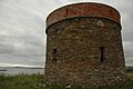
Other buildings built by David Balfour include the Dishan Tower. Locals call it The Douche. This was a saltwater shower building with a dovecote (a home for doves) on top. It's a well-known landmark because you can see it clearly when you arrive by sea. However, the building is now in bad condition, with missing roof slates.

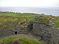
An even older building on Shapinsay is the Iron Age Broch of Burroughston. A broch is an ancient round tower. Only the inside of this partly buried building has been dug up. Visitors can look down into the broch from the surrounding mound. The remaining stone walls are about three metres (10 ft) high and more than four metres (13 ft) thick in some places.
This broch also shows David Balfour's influence. He arranged for archaeologists to dig up the site in 1861. After the dig, the site was not looked after and filled with plants and rubble. It was cleared again in 1994.
The Shapinsay Heritage Centre is in what used to be Balfour's smithy (a blacksmith's workshop). It also has a craft shop and a cafe. The castle's old gatehouse is now the village pub.
How Does Shapinsay Make Money?

Like other Orkney islands, Shapinsay has good farmland. Farms here raise beef and lamb, sending thousands of cattle and sheep away each year. Orkney Ferries provides transport for people and vehicles. Because Shapinsay is close to Kirkwall, it has better connections to the Orkney Mainland than most other North Isles. There are six ferry crossings a day, and the trip takes about 25 minutes. This allows some people to travel to Kirkwall for work or school.
The Shapinsay development trust is working on the island's community plan. They own the island's wind turbine, which was finished in August 2011. The community voted to build it. The trust believes the turbine could earn over £5 million in its 25-year lifespan.
Small businesses on Shapinsay include a company that makes jam and chutney using old-fashioned methods. There is also a studio that offers art courses, like making stained glass.
Education and Culture on Shapinsay
Shapinsay has a primary school. In the 2006–7 school year, it had 26 students. Before 1995, the island also had a secondary school. But it closed because fewer students were enrolling and transport to Kirkwall improved. Now, older students travel to Kirkwall for secondary school.
The school also works as a community centre. It hosts a learning centre supported by the UHI Millennium Institute. This centre uses the internet, email, and video calls. This allows students on Shapinsay to study without leaving the island.
In December 2006, the students put on a Christmas show with a school in Grinder, Norway. The schools used the internet to work together. The show ended with the Norwegian students singing in English and the Shapinsay students singing in Norwegian. This was part of an ongoing connection between the schools. The children exchange letters and cards.
Shapinsay Community School has won a Silver Award from the international Eco-Schools programme. Students have checked how much energy the school uses. They have also helped plant over 600 trees near the school and run campaigns to save energy. Shapinsay students also won an award for creating a booklet about crofting (small-scale farming) on the island.
Shapinsay's Folklore and Legends
Cubbie Roo is the most famous giant in Orkney stories. He is said to have lived on the island of Wyre. He used Orkney's islands as stepping stones. Many large stones on Orkney islands, including Shapinsay, are said to have been thrown or left by the giant. Cubbie Roo's Burn is a waterway on Shapinsay. Cubbie Roo's Lade is a pile of stones on the shore near Rothiesholm Head. People say it was the start of a bridge between Shapinsay and Stronsay that the giant never finished.
In 1905, The Orcadian newspaper reported that a strange creature was seen off the coast of Shapinsay. It was said to be the size of a horse, with a spotted body covered in scales. Some islanders thought it was a sea serpent. Others believed it was just a very large seal.
Images for kids
-
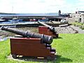
Cannon decorate the quayside of Balfour Harbour on Shapinsay, the round tower in the background is The Douche
-
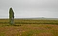
The Mor Stein standing stone
-
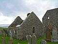
Graveyard on Shapinsay, including the burial aisle of the Balfour family
-
The remains of Shapinsay gas works
-
Elwick, looking across the town square
-
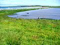
Lairo Water and ayre
-
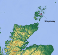
Location in relation to Scotland
-
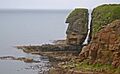
Sea stack on the east coast at Lingavi Geo
-
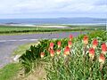
Many of the farms have red hot pokers, which bloom in June.
-
Burroughston Broch
-
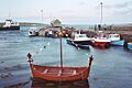
The pier at Balfour
See also
 In Spanish: Shapinsay para niños
