Burroughston Broch facts for kids

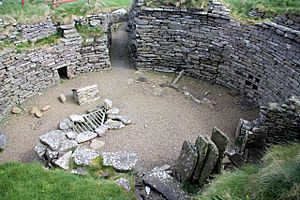
Interior of Burroughston Broch
|
|
| Location | Shapinsay |
|---|---|
| Coordinates | 59°04′25″N 2°48′11″W / 59.073501°N 2.80297°W |
| Type | Broch |
| History | |
| Periods | Iron Age |
| Official name | Hillock of Burroughston,broch |
| Designated | 15 December 1953 |
| Reference no. | SM1421 |
Burroughston Broch is a really old stone tower from the Iron Age. It's found on the island of Shapinsay in the Orkney Islands of Scotland. This amazing ancient building looks out over the North Sea from the northeast side of Shapinsay. People dug up parts of it in the mid-1800s, and it's still in great shape today! Its strong stone walls are super thick, up to four metres in some places. You can even see a whole room still standing near the entrance.
Where is Burroughston Broch?
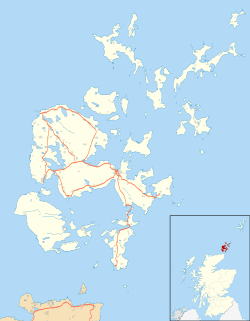
Burroughston Broch is located on the northeast side of Shapinsay island. It offers great views of the North Sea. The broch is about 4 miles from the main ferry pier. Just a little to the south, you'll find Linton Bay. This ancient tower sits at the bottom of a gently sloping field. It is right above the low, rocky shoreline. It's known as one of the best-preserved brochs in all of Orkney.
What Does Burroughston Broch Look Like?
The walls of Burroughston Broch are very wide. They measure about 18 metres across on the outside. Inside, the space is about 10 metres wide. From the outside, the building mostly looks like a grassy mound. Not much of the outer wall can be seen.
The main entrance is on the east side. It's about 4 metres long, 1.2 metres wide, and 1.8 metres tall. There's a long guard room that opens from the left side of this passage. Inside the broch, you can still see the outer part of an upper gallery. There are also signs of an opening that once led to this upper level. A deep well is found in the floor of the broch. The top part of the well is made of dry stone. The lower part is cut right into the rock.
In the sloped area in front of the broch's entrance, there are hints of other buildings. These "out-buildings" are now covered with grass. You can still see parts of a wall, a ditch, and a rampart. These features probably once went all the way around the broch.
Who Excavated Burroughston Broch?
The broch was dug up around 1862. This happened shortly after another famous site, Maeshowe, was discovered. Colonel D. Balfour's workers did the digging. They were guided by an expert named George Petrie. Petrie wrote down notes about the structures he found. Meanwhile, Sir Henry Dryden drew a map of the site. The digging only happened inside the broch. A small area right outside the entrance was also explored.
We don't know much about the items found during the excavation. Petrie said they mostly found pieces of deer antlers. There were also many bones from oxen and sheep. They also found "several rude stone vessels of different sizes." One of these might have been a triangular lamp.
 | Victor J. Glover |
 | Yvonne Cagle |
 | Jeanette Epps |
 | Bernard A. Harris Jr. |


