
North Ronaldsay facts for kids
| Gaelic name | N/A |
|---|---|
| Norse name | Rínansey |
| Meaning of name | Old Norse, possibly "Ringa's Isle" |
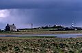
 A view of the house and loch at Garso on North Ronaldsay, with the lighthouse in the distance |
|
| OS grid reference | HY759542 |
| Coordinates | 59°22′N 2°25′W / 59.37°N 2.42°W |
| Physical geography | |
| Island group | Orkney |
| Area | 690 hectares (2.7 sq mi) |
| Area rank | 64 |
| Highest elevation | 20 metres (66 ft) |
| Administration | |
| Sovereign state | United Kingdom |
| Country | Scotland |
| Council area | Orkney Islands |
| Demographics | |
| Population | 72 |
| Population density | 10.4 people/km2 |
| Largest settlement | Hollandstoun |
North Ronaldsay is the most northern island in the Orkney Islands of Scotland. It is the fourteenth largest island in this group. This island is famous for its old lighthouse, many different birds that visit, and a special kind of sheep. The island is even mentioned in old stories called the Orkneyinga saga.
Contents
What's in a Name?
North Ronaldsay, and its sister island South Ronaldsay, are both named after a person called St Ronald.
Exploring North Ronaldsay's Geography
North Ronaldsay is about 4 kilometers (2.5 miles) north of its closest neighbor, Sanday. The island is about 5 kilometers (3 miles) long. It has two big sandy bays. These are Linklet Bay on the east and South Bay in the south. The west side of the island is very rocky. It has many small islands called skerries.
North Ronaldsay is a low-lying island. It is very open to the weather. The climate changes a lot and can be stormy. The waters around the island are rough and dangerous. Many ships have been lost here. This is why a lighthouse was built on the island very early.
Main Settlement: Hollandstoun
Hollandstoun is the biggest village on the island. It is located in the south. It is about halfway between the airfield and the pier. North Ronaldsay also has a bird observatory. This is a place where scientists study birds.
The Famous Dry Stone Dyke
A long stone wall goes all the way around the island. This wall is called a dyke. Its job is to keep the special local sheep away from the fields where crops grow. These sheep like to eat seaweed!
A Glimpse into North Ronaldsay's Past

On the southern tip of the island, you can find an old Iron Age building. It is called the Broch of Burrian. A broch is a type of round stone tower. When people dug here in 1870-1871, they found many old items. These items were from the Iron Age and the Pictish times. People lived here until the Norse arrived in the 800s.
Norse History and Legends
The Orkneyinga saga is an old Norse story. It tells about Torf-Einarr, a Norse Earl of Orkney from the 900s. The story says that Torf-Einarr killed Hálfdan Longlegs on North Ronaldsay. This was revenge for Hálfdan killing Torf-Einarr's father. Hálfdan and his brother had trapped Torf-Einarr's father in his house and set it on fire.
Hálfdan ran away to Orkney. Torf-Einarr found Hálfdan hiding on North Ronaldsay. The old stories say Hálfdan was captured. He was then sacrificed to the god Odin. This was a very old and harsh ritual.
Old Buildings and Shipwrecks
In 1586, a ship called the Joseph was wrecked on Bride's Ness beach. The crew saved some brass cannons. But the Earl of Orkney took them.
Holland House was built in 1727. The Old Beacon lighthouse was built in 1789. It was the third lighthouse built by Thomas Smith. He built it for the Northern Lighthouse Board.
Getting to North Ronaldsay
You can fly to North Ronaldsay from Kirkwall. Kirkwall is on the Orkney Mainland. Flights leave from North Ronaldsay Airport. A ferry also travels to the island once a week. Orkney Ferries operates this service. In the summer, ferries run on Tuesdays and Fridays. Flights are made cheaper for people. This helps visitors come to the island.
North Ronaldsay's Economy

The main jobs on the island are crofting and sheep farming. Crofting is a type of small-scale farming. The special North Ronaldsay sheep are often farmed together by the community. Tourism is also very important for the island's economy.
The island has about 60 people living there. About half of them are from families who have lived there for a long time. The other half are new people who have moved to the island. People on the island want to attract new families. They hope this will help keep the local school open.
Wildlife and Nature on North Ronaldsay
The island has a bird observatory. It was started in 1987. Its main goal is to watch bird populations. It also tracks how birds migrate. North Ronaldsay is known as one of the best places in the country to watch birds. This is especially true during spring and autumn. Many different kinds of birds can be seen then. It is often an amazing sight.
Extinct Animals of the Past
The great auk was a large bird. It lived in the North Atlantic. It could not fly. This bird became extinct in 1844. North Ronaldsay was a home for the great auk. Many of them lived there before they disappeared. At one old site, nearly 14% of the bird bones found were from great auks.
North Ronaldsay was also home to the Atlantic walrus. Walruses lived here until the mid-1500s.
The Lighthouses of North Ronaldsay
The Old Beacon Lighthouse
Dennis Head is in the northeast of the island. It is home to an old lighthouse called the Old Beacon. The light first shone in 1789. It was built by Thomas Smith. This was one of many island lighthouses he built. Robert Stevenson, Smith's stepson, also helped build it.
In 1809, other lighthouses were built nearby. So, the North Ronaldsay light was no longer needed. It was turned off. The round stone tower was kept as a landmark. The original light room at the top was changed. It got a new roof with a special ball shape on top. The stone stairs inside were taken down. The old houses where the lighthouse keepers lived are still there. They have no roofs but are mostly complete. In 2006, this building was shown on a TV show called Restoration.
The Modern Lighthouse
A new lighthouse was built nearby in 1852. The modern lighthouse is at the north of the island. It is at a place called Point of Sinsoss. This lighthouse has Britain's tallest lighthouse tower on land. The old fog horn was replaced. Now, an electric horn is used. This horn makes three loud blasts every 60 seconds. The fog signal is still used today.
Education on the Island
The community has one school. It is called North Ronaldsay Primary School. It had only one student until July 2017. That student then finished school. Different groups now use the school building.
Images for kids
-
A view of the house and loch at Garso on North Ronaldsay, with the lighthouse in the distance
-
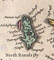
Blaeu's Atlas of Scotland, published in 1654
-
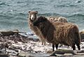
The unique local sheep, which eat seaweed
See also
 In Spanish: North Ronaldsay para niños
