
Eday facts for kids
| Norse name | Eiðøy |
|---|---|
| Meaning of name | Old Norse for "isthmus island" |
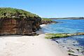
 One of Eday's beaches, with sea caves adjacent to the southern end of Calf Sound |
|
| OS grid reference | HY560338 |
| Coordinates | 59°10′19″N 2°46′59″W / 59.172°N 2.783°W |
| Physical geography | |
| Island group | Orkney |
| Area | 2,745 hectares (10.6 sq mi) |
| Area rank | 31 |
| Highest elevation | Ward Hill 101 metres (331 ft) |
| Administration | |
| Sovereign state | United Kingdom |
| Country | Scotland |
| Council area | Orkney Islands |
| Demographics | |
| Population | 130 |
| Population density | 5.8 people/km2 |
| Largest settlement | Backaland |
 |
|
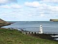
| Lighthouse on Calf Sound, Eday. The land on the upper right of the picture is the northern tip of the Calf of Eday. | |

Calf of Eday Lighthouse
Calf Sound Location in Orkney Islands
|
|
| Location | Eday Orkney Scotland United Kingdom |
|---|---|
| Coordinates | 59°14′13″N 2°45′48″W / 59.236906°N 2.763399°W |
| Year first constructed | 1909 (first) |
| Year first lit | 2002 (current) |
| Automated | 2002 |
| Foundation | concrete base |
| Construction | aluminium tower |
| Tower shape | octagonal prism tower with balcony and lantern |
| Markings / pattern | white tower and lantern |
| Height | 9 metres (30 ft) |
| Focal height | 9 metres (30 ft) |
| Characteristic | Fl (3) WRG 10s. |
| Admiralty number | A3728 |
| NGA number | 3288 |
| ARLHS number | SCO-034 |
Eday (called Aidee in Scots) is one of the beautiful Orkney islands. These islands are found north of the Scottish mainland. Eday is part of the North Isles group. It is about 24 kilometres (15 mi) away from the Orkney Mainland.
Eday covers about 27 square kilometres (10 sq mi). This makes it the ninth largest island in the Orkney group. The island's main rock is Old Red Sandstone. You can see this rock clearly along the sea-cliffs.
Eday has many old Neolithic tombs that are still in good shape. There is also proof of people living here during the Bronze Age. You can even find remains of a Norse-era castle. Later, under Scottish rule, a large house called Carrick House was built. It was even a special town (a burgh) for a short time.
During the British era, farming methods improved. However, the number of people living on Eday has gone down a lot since the mid-1800s. In recent years, the Eday Partnership has worked hard to help the island's economy grow. The names of places on Eday show its mixed history of languages. The island's nature and surrounding seas are home to lots of amazing wildlife.
Contents
Exploring Eday's Land and Rocks

Eday is 14 kilometres (8.7 mi) long from north to south. But it's very narrow in the middle, only about 500 metres wide. This narrow part is between the Sands of Doomy and Bay of London. People say the island looks "nipped at the waist."
The middle of Eday is mostly moorland. This land is covered with heather plants. Most of the farming happens along the coasts.
Eday's Highest Points
The highest spots on Eday include Flaughton Hill in the center. There's also Fersness Hill on the west side. Vinquoy Hill is in the north. Ward Hill in the south reaches 101 metres (331 ft) high. In Orkney, many islands have a "Ward Hill." This name comes from the Norse word varði. In the past, these hills were used to light warning beacons.
The biggest body of water on Eday is the sea, southeast of Vinquoy Hill. Loch of Doomy is on the west side of the narrow "waist." The smaller Loch Carrick is on the north coast.
Where People Live on Eday
People live in farmhouses spread out along the coast. There isn't one main village on the island. Calfsound has the most people. Other groups of homes are at Millbounds on the east coast. Millbounds has a post office and a community center. Backaland is in the south. This is where the ferry from the Mainland arrives.


Eday is surrounded by many small islands. These islands form a "jigsaw" of green and russet colors. Calf of Eday is 350 metres (0.2 mi) north of Calfsound. To the east is Sanday, across the Eday Sound. Stronsay and Linga Holm are to the southeast. Muckle Green Holm is to the southwest. Egilsay is about 5 kilometres (3.1 mi) to the west. Rusk Holm, Faray and Holm of Faray are to the northwest. Beyond them is the larger island of Westray.
Understanding Eday's Rocks
Like nearby islands, Eday is mostly made of Middle Devonian Old Red Sandstone. This rock formed in the Orcadian Basin. The "Eday Group" is a name for a thick layer of sandstones found in Orkney. Eday and the area around Eday Sound are the main places to study these rocks. This rock layer can be up to 800 metres (2,600 ft) thick. It is mostly yellow and red sandstones. It also has grey flagstones and marls.
This rock is easy to quarry (dig out). Some yellow sandstones from Fersness were used to build St Magnus Cathedral in Kirkwall. The rocks on Eday are folded into a large bend called the Eday Syncline. The newest rocks are in the north of the island. The oldest rocks are on the east and west sides.
Eday Through Time: A Look at History
Ancient Times: Prehistory on Eday
We don't have much proof of early human life in Orkney. But the many ancient houses and huge Neolithic buildings are special. They are unlike anything else in the United Kingdom.
The chambered cairn of Vinquoy is a very old tomb. It sits high up, looking over the Calf Sound. This tomb is 17 metres (56 ft) wide and 2.5 metres (8.2 ft) tall. It has a narrow entrance that leads to a main room. This room has four smaller side rooms.
Other interesting old sites on Eday include the Stone of Setter. This standing stone is 4.5 metres (15 ft) tall. It is one of the tallest stone pillars in Orkney. There are two more chambered tombs at Braeside and Huntersquoy. Another tomb is on the Calf of Eday. This tomb was dug up in 1936–37. It has a small room with two parts. It also has a larger room with four stalls. This larger room has its own entrance and was likely added later.

Eday also has several Bronze Age sites. These sites show less dramatic remains. At Warness, there is a burnt mound from this time. There are also ruins of two houses from the same age on Holm of Faray. The Fold of Setter is a large Bronze Age enclosure. It is 85-metre-diameter (279 ft) wide. In the Iron Age, a large roundhouse was built at Linkataing. It contained a saddle quern, a tool for grinding grain. Later, the Picts lived in Orkney. However, we don't have much archaeological proof of them on Eday.
Viking Settlers on Eday
We don't know exactly when or how the Vikings came to Orkney. But we know they were here. The names of places on Eday clearly show a Norse presence. We don't know much about daily life on the island during this time. The ruins of the Castle of Stackel Brae are from the Norse era. This castle was built in the 12th or 13th centuries. It lies under a green mound near the Bay of Greentoft. This castle might have been the most important building on Eday back then.
Scottish Rule and Changes
In 1468, Orkney became part of the Kingdom of Scotland. Many Scottish business people came to the islands. They helped create a diverse community. This community included farmers, fishermen, and merchants. They called themselves comunitatis Orcadie. They became good at protecting their rights.
In 1561, during the Reformation, Edward Sinclair was given land on Eday. His job was to protect the Bishop of Orkney. Later that year, he was involved in a dispute in Kirkwall.
His son, William, later took over the Eday estate. But it got into debt. In 1601, William tried to sell the land. The new owner sent people from Caithness to Eday. This worried Earl Patrick of Orkney. Earl Patrick used the bad relationship between Edward and William. He claimed to act for Edward. Earl Patrick then took over the Eday rents for himself. He also made money from digging building stone from Towback quarry.
John Stewart, Earl of Carrick, Earl Patrick's brother, was given Eday in 1632. He built Carrick House at Calfsound soon after. He used peat to make salt from salt pans. These were at Carrick and on the Calf of Eday. Salt making was a big industry then. Peat was also important. Islands like Sanday and North Ronaldsay got most of their fuel from Eday. Peat was even sent to whisky distilleries in mainland Scotland.
Stewart had big plans for Calfsound. He called it the "town and port" of Carrick. It became a burgh, a special town with rights. It was the only other burgh in Orkney besides Kirkwall. But it never really grew much in that location.
British Era and Modern Times

From the early 1700s, Orkney became part of the new Kingdom of Great Britain. This was a time of big interest in improving agriculture. But these changes didn't really affect Orkney until the mid-1800s. For example, potatoes weren't grown on Eday until around 1780.
Carrick House saw some excitement in 1725. The owner, James Fea, knew a trader named "Mr Smith." Smith was actually the famous pirate John Gow. Gow tried to escape to Eday. But his ship, Revenge, got stuck near the Calf of Eday. Fea's men captured Gow and held him at Carrick House. Fea received a large reward for this. The bell from Gow's ship is still at Carrick House today.
In the early 1800s, the kelp industry provided many jobs. Kelp is a type of seaweed used for various products. But when the kelp market crashed around 1830, it caused great hardship. Many families moved from North Ronaldsay to Eday to find land. As the population grew, land became more valuable. However, the 1900s saw a decline. By 2001, Eday's population was much smaller than it was 160 years earlier.
| 1841 | 1881 | 1891 | 1931 | 1961 | 1981 | 1991 | 2001 | 2011 |
|---|---|---|---|---|---|---|---|---|
| 944 | 730 | 647 | 430 | 198 | 147 | 166 | 121 | 160 |
The island's population was 160 people in the 2011 census. This was an increase of over 30% since 2001.
Understanding Eday's Name

The name "Eday" comes from the Old Norse word eið. It means "isthmus island." An isthmus is a narrow strip of land connecting two larger landmasses. This name was used when the isthmus was a path for moving goods or boats.
Many other places in the North Atlantic islands have similar "eið" names. In Orkney, these include Hoxa on South Ronaldsay and Aith. The Bay of Doomy on Eday might also come from dómr-eið. This means "isthmus of the courthouse." It suggests it was an important meeting place during the Norse period. In the 1600s, Eday was also known as "Heth Øy."
Place names in Orkney are a mix of Norse, Scots, and English. Any older Pictish names on Eday seem to have disappeared. The common ending "-quoy" comes from Old Norse kví-ló. It means an enclosed area in a marsh. Skaill, on the east coast, comes from Norse skáli. This suggests an important farm on good land. The Bay of London also has Norse roots. Lund-inn means "woodland," which is not true for Eday today. Lundi also means "puffin." Puffins might have nested there in the past.
Orkney was Christian before the Vikings arrived. Some local "Papa" names show where pre-Norse monks lived. The farm of Papleyhouse might be one such link. The word "geo" is common along the rocky coast. It comes from Norse gjá. It means a narrow, deep crack in a cliff.
Travel and Jobs on Eday

You can get to Eday by both sea and air from the Orkney Mainland. Orkney Ferries offer daily ferry trips to Backaland on Eday from Kirkwall. Loganair operates the Orkney inter-island air service. This service connects Kirkwall Airport with Eday London Airport.
In 2014, the Orkney Islands Council started thinking about building bridges. They are looking into connecting seven of the Orkney Islands. This includes a possible 2.6-mile bridge between Eday and Papa Westray.
Farming and crofting are the main jobs on Eday. Raising livestock (farm animals) is especially important. Flocks of sheep are also kept on Faray.

The European Marine Energy Centre (EMEC) is a research center in Stromness. It is supported by the Scottish Government. EMEC has a wave testing system on the Orkney mainland. They also have a tidal power testing station on Eday. This station overlooks the Fall of Warness. The site was chosen because of its strong ocean currents. These currents can reach almost 4 metres per second (7.8 kn) during spring tides. There are seven testing spots offshore. They are connected to the national power grid by an underground cable.

The Eday Partnership is a local group working to help the island's economy. They have started many projects. These include the Eday Heritage Centre. They also bought a new diesel tank for the island. Eday's community projects added £380,000 to the island's economy from 2005-2007. A 900 kW community-owned wind turbine is also planned. The money from this turbine is expected to help people afford fuel. It will also support new community businesses and create affordable homes.
In July 2008, the Eday Heritage and Visitor Centre opened. It is in a restored former Baptist Church. It has a heritage display area and an archive. There is also a café and a tourist information point. The Eday Oral History Project records life on the island in the past. This project is also housed in the center. The center even has its own 6 kW wind turbine.
Eday's Amazing Wildlife

In the early 1800s, people described Eday as a "mossy island." Much of it was "barren marshy heaths." Over 120 types of wild plants have been found on Eday. This includes bog myrtle, which is found nowhere else in Orkney.
In the mid-1600s, Eday was said to be "absolutely full of moorland birds." Today, you can see red-throated divers on Mill Loch. Arctic skuas and bonxies live on the moors. Black guillemots are found offshore. Shore birds include meadow pipits, rock pipits, and ringed plovers.
The small woodland at Carrick House attracts many migrating birds. Otters can be seen around the coasts. There are groups of harbour and grey seals on nearby small islands. White-beaked dolphins, minke whales, and killer whales sometimes visit the waters around Eday. A local ranger offers guided walks throughout the year.
Famous People from Eday
- William Spence, an Australian union leader and politician, was born on Eday in 1846.
- John Flaws Reid, who was a Member of Parliament in Canada, was born on Eday in 1860.
- Rev Norman Miller Johnson FRSE (1887-1949) was a minister on Eday and passed away here in 1949.
Images for kids
-
One of Eday's beaches, with sea caves adjacent to the southern end of Calf Sound
-
Lighthouse on Calf Sound, Eday. The land on the upper right of the picture is the northern tip of the Calf of Eday.
See also
 In Spanish: Eday para niños
