
Broch of Gurness facts for kids

Broch of Gurness
|
|

Location in Orkney Islands
|
|
| Location | Mainland, Orkney |
|---|---|
| Region | Scotland |
| Coordinates | 59°07′26″N 3°04′53″W / 59.1239°N 3.0813°W |
| Type | Iron age settlement |
| History | |
| Periods | Iron Age |
| Site notes | |
| Ownership | Historic Scotland |
| Public access | Yes |
| Official name | Aiker Ness,Broch of Gurness,broch and settlement |
| Designated | 4 May 1994 |
| Reference no. | SM90157 |
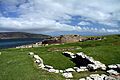
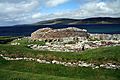
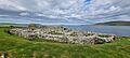
The Broch of Gurness is an amazing ancient village from the Iron Age in Scotland. It's located on the northeast coast of Mainland Orkney, looking out over Eynhallow Sound. This historic site is about 15 miles north-west of Kirkwall. Long ago, a large community of people lived here.
Contents
What is the Broch of Gurness?
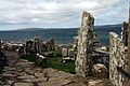
People started living at this site between 500 and 200 BC. The main part of the village is a tall stone tower called a broch. This tower probably stood about 10 metres (33 feet) high. Inside, stone slabs divided the space into different areas.
Inside the Broch Tower
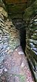
The tower has two layers of stone walls built without mortar. Between these walls are stone-floored passages or galleries. You can reach these by climbing steps. Stone ledges inside suggest there was once an upper floor made of wood. The roof was likely made of thatch. A walkway on top of the wall was connected to the ground floor by stairs.
The broch also has two fire pits, called hearths, for cooking and warmth. There's also a secret underground stone tank with steps leading down into it. This tank might have been important for religious reasons. People in the Iron Age sometimes believed in special powers from underground.
How Big Was the Broch?
Today, the remains of the central tower are still quite tall, up to 3.6 metres (11.8 feet) high. The stone walls are very thick, reaching up to 4.1 metres (13.5 feet). The roof of the tower was probably shaped like a cone.
The main family or clan of the area likely lived in the tower. It also served as a safe place for everyone in the village if there was an attack.
Changes Over Time
Even as the broch started to fall apart, people kept living in it. They changed the original structures. For example, the underground tank was filled in, and the inside of the tower was divided differently. What you see today shows how the broch was used in its later years.
The Village Around the Broch
The entire settlement is protected by three ditches dug into the rock. These ditches have stone walls, called ramparts, around them. The whole area is about 45 metres (148 feet) across.
Between the inner ditch and the tower, you can find the remains of many small stone houses. These houses had small yards and sheds. They were built after the main tower but were part of the village from the start. A "main street" connected the outside entrance to the broch tower. The Broch of Gurness is one of the best-preserved broch villages we know of.
History of the Broch Village
Archaeologists found pieces of a Roman pot, called an amphora, at the site. This pot was made before 60 AD. This discovery supports old stories that a "King of Orkney" met with Emperor Claudius in Colchester in 43 AD.
Sometime after 100 AD, people stopped using the broch tower, and the ditches were filled in. However, people continued to live in the village until about the 5th century AD. This was during the time of the Pictish people. By then, the broch tower was no longer used. Some of its stones were even used to build smaller homes on top of the older buildings. By the 8th century, the site was just a single farm.
In the 9th century, a Norse woman was buried at the site. Her grave was lined with stones and contained two bronze brooches, a sickle, and an iron knife. Other discoveries suggest that Norse men were also buried here.
Today, the Broch of Gurness is looked after by Historic Environment Scotland.
Gallery
-
Broch of Gurness
-
-
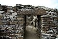
Entrance to the main building
-
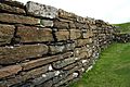
Detail of the wall
-

-
View from the south
-

Broch of Gurness
-

Broch of Gurness
-
Broch of Gurness
-
Broch of Gurness
.JPG)
.JPG)
.JPG)
.JPG)
.JPG)
.JPG)

.jpg)
.jpg)
.jpg)
See also
- Brough of Birsay
- Point of Hellia
- Sands of Evie
