
Gairsay facts for kids
| Norse name | Gáreksey |
|---|---|
| Meaning of name | Gárekr's isle |
 Gairsay from Mainland Orkney |
|
| OS grid reference | HY446222 |
| Coordinates | 59°04′59″N 2°57′58″W / 59.083°N 2.966°W |
| Physical geography | |
| Island group | Orkney |
| Area | 240 hectares (0.93 sq mi) |
| Area rank | 99= |
| Highest elevation | 102 metres (335 ft) |
| Administration | |
| Sovereign state | United Kingdom |
| Country | Scotland |
| Council area | Orkney Islands |
| Demographics | |
| Population | 3 |
| Population density | 1.2 people/km2 |
Gairsay is a small island in Orkney, Scotland. It is located about 1.5 kilometers (1 mile) off the coast. The island is around 2 kilometers (1.2 miles) long and 1 kilometer (0.6 miles) wide. Gairsay has a hill shaped like a cone and a small, safe harbor called Millburn Bay. This harbor is protected by a piece of land known as the Hen of Gairsay. In Old Norse, the island was called Gáreksey, which means "Gárekr's isle".
Contents
Island History
Viking Times on Gairsay
Long ago, during the Viking Age, Gairsay was an important place. According to an old story called the Orkneyinga saga, a famous Norse chieftain named Sweyn Asleifsson lived here. He was one of the last great Vikings. Sweyn spent his summers farming. But in winter, he lived on Gairsay with about eighty of his warriors. After planting crops in the spring, Sweyn would go on Viking raids. He traveled down the coasts of Scotland, England, and Ireland. Sweyn Asleifsson died in 1171 while trying to conquer Dublin.
Gairsay from the 1600s to the 1800s
In the 1600s, a large house called Langskaill was built on the same spot where Sweyn's estate once stood. A rich merchant named Sir William Craigie built it. He lived there with his wife, Margaret Honyman. Sir William was a member of Parliament. He passed away in Edinburgh in 1712.
Records show that in 1831, 69 people lived on Gairsay. By 1841, there were 71 people living in fifteen families. The island used to be known for making "kelp," which is a type of seaweed used for different things. However, by the 1840s, kelp was no longer being made there.
The population of Gairsay started to decrease. In 1851, only 41 people lived on the island in six families. Ten years later, this number dropped to 34 people in just five families. By 1881, there were 37 people in four families.
In more recent years, the McGill family bought the island in 1968. They now farm the land. Gairsay is special because it is one of the few Scottish islands allowed to print its own postage stamps. This is because the island does not have a regular Royal Mail service.
Images for kids
-
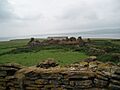
An old, unused farm building on Gairsay.

See also
 In Spanish: Gairsay para niños
