
Lossiemouth facts for kids
Quick facts for kids Lossiemouth
|
|
|---|---|
 |
|

Lossiemouth
|
|
| Population | 6,840 (2020) |
| OS grid reference | NJ235705 |
| • Edinburgh | 122 mi (196 km) |
| • London | 447 mi (719 km) |
| Council area | |
| Lieutenancy area |
|
| Country | Scotland |
| Sovereign state | United Kingdom |
| Post town | LOSSIEMOUTH |
| Postcode district | IV31 |
| Dialling code | 01343 |
| Police | Grampian |
| Fire | Grampian |
| Ambulance | Scottish |
| EU Parliament | Scotland |
| UK Parliament |
|
| Scottish Parliament |
|
Lossiemouth (Scottish Gaelic: Inbhir Losaidh) is a town in Moray, Scotland. It sits where the River Lossie meets the sea. Long ago, it was the main port for the nearby town of Elgin. Over time, it grew into an important fishing town.
People have lived in this area for more than 1,000 years. However, the Lossiemouth you see today was built over the last 250 years. It started as four smaller communities that eventually joined together. From 1890 to 1975, it was a special type of town called a police burgh, known as Lossiemouth and Branderburgh.
The first main settlement was Stotfield, located northwest of the town. Next came the Seatown, a small area with historic fisher cottages. When a new harbour was built on the River Lossie in the 18th century, the planned town of Lossiemouth was created. It had streets laid out in a grid pattern. Finally, Branderburgh grew in the 19th century around the new harbour. This part of town, built on Coulard Hill, looks very impressive from a distance.
Contents
- Exploring Lossiemouth's Past
- Lossiemouth's Natural World
- Lossiemouth's Climate
- People of Lossiemouth
- Lossiemouth's Economy
- Getting Around Lossiemouth
- Learning in Lossiemouth
- Places of Worship
- Fun and Culture in Lossiemouth
- Sports in Lossiemouth
- Lossiemouth's Language
- Sister City
- Famous People from Lossiemouth
- Interesting Facts About Lossiemouth
Exploring Lossiemouth's Past
From Roman Times to the Middle Ages

Even though the Romans never fully took over northern Scotland, they did travel to the Moray Firth coast. Ancient Roman forts have been found nearby. A Greek-Roman mapmaker named Ptolemy (who lived around 90-168 AD) described the mouth of the River Lossie in his book. This shows that people have lived in this area for a very long time.
A Celtic hermit, St Gervadius, lived in a cave near the sea entrance of Loch Spynie. He was known as St Gerardine later on. People say he would carry a flaming torch around the headland to warn ships about dangerous rocks. He died in 934 AD, and his cave was a popular place for visitors until the 1500s.
The settlement at the river mouth was very important for trade. In 1383, there was a disagreement about who owned the port of "Losey." This port was used by merchants from Elgin. It was a busy place for both fishing and trading.
Around 1600, big storms caused sand and rocks to block the sea entrance to Loch Spynie. To stop flooding, the river was moved away from the loch. This is why the River Lossie has a sharp bend today.
Modern Lossiemouth grew from five older communities: Kinneddar, Stotfield, Seatown, Lossiemouth, and Branderburgh. Kinneddar and Stotfield are the oldest.
Kinneddar: An Ancient Village

Kinneddar was once a farming village, but it has now disappeared. An old farmhouse still keeps its name. This area was once a Pictish settlement. Many carved stones from around the 8th or 9th century have been found here. These stones show that there was a Christian community.
A bishop named Richard lived at Kinneddar, making it an important church center for a while. Old maps from the 1500s show this farming community as "King Edward." This name probably came from how locals said "Kinneddar."
In 1308, Robert the Bruce, a famous Scottish king, captured and destroyed many castles in Scotland. He burned Kinneddar castle. Kinneddar village was still quite big in the early 1800s but became smaller as the new Lossiemouth grew nearby.
Stotfield: A Fishing Hamlet

Early maps from the 1500s show Stotfield. Its name means 'horse fold'. King David I brought new settlers to Scotland to help control powerful lords. Stotfield might have started around 1130.
In the Middle Ages, Stotfield was mainly a farm village with some fishing. Over time, fishing became more important. The people became either farm workers or fishermen.
The Stotfield Fishing Disaster
A terrible storm hit Stotfield on December 25, 1806. Every able-bodied man in the village was lost at sea. This event had a huge impact on the community. Even today, fishermen in Lossiemouth still remember this sad story.
Seatown: A New Beginning

The Seatown was created in the late 1600s. This happened after the old port at Spynie became blocked off from the sea by sandbanks. Merchants from Elgin wanted a new harbour at the mouth of the River Lossie for bigger trading ships.
Fishermen, however, continued to use the beach at Seatown for their boats. Locals sometimes call Seatown "The Toonie" or "Dogwall." The name "Dogwall" came from the dog-skins that were dried there to make floats for fishing nets.
Lossiemouth: The Planned Town

In 1685, the Elgin council asked a German engineer, Peter Brauss, to see if a harbour could be built at the River Lossie's mouth. He said it was possible. The first attempts failed, but by 1764, a new jetty was built.
At the same time, a new, planned town called Lossiemouth was laid out. It had streets that ran straight and crossed each other. The fishermen lived in Seatown, while builders and merchants lived in the new Lossiemouth. Later, a canal was dug to drain Loch Spynie. This canal created a physical barrier between the two communities.
Branderburgh: The Fishing Hub

By the early 1800s, the river harbour was busy but not big enough for the future. So, in 1834, a company was formed to build a new harbour at Stotfield Point.
The new harbour was built between 1837 and 1839. It started small but was later made bigger and deeper. This encouraged many fishing families to move to Lossiemouth. The harbour became home to a large herring fishing fleet and also welcomed trading ships. Because of this, the company decided to build a second harbour basin just for fishing boats. This new basin opened in 1860.

Branderburgh, with its wide streets, kept growing westward. By the early 1900s, it finally joined with Stotfield. A lot of sandstone was dug up from the east side of town to build all these new houses. After Lossiemouth and Branderburgh became a police burgh in 1863, the town became known simply as Lossiemouth. The Lossiemouth Town Hall was finished in 1885.
Fishing Boats of Lossiemouth
The fishing boats used in Lossiemouth were similar to those along the entire Scottish east coast. They changed over time as technology improved:
- The Skaffie boats appeared in the early 1800s. They were first small enough to be pulled onto the beach. Later, bigger versions were built for larger harbours.
- The Fifie was the most common fishing boat from the 1850s to the 1880s. These boats had straight fronts and backs. Later Fifie boats were decked (had a floor) and were built with planks laid edge-to-edge, making them very fast.
- The Zulu boat was named after a war happening in South Africa at the time. A Lossiemouth fisherman, William 'Dad' Campbell, designed the first one. These boats were very popular because they were big and fast. They could reach fishing areas quickly and bring the catch back fast.
- Steam Drifters used steam engines and drift nets. They were larger than sailing boats, so they could carry more nets and catch more fish. They could travel faster and were less affected by weather. This meant more time could be spent fishing. However, they were expensive to build and run.
- Seine Netters were initially converted from older boats. From 1906, petrol and paraffin engines were added. As engines became more powerful, sails were no longer needed. Lossiemouth fishermen saw that Danish boats were catching lots of white fish using seine nets. John Campbell, who was related to the Zulu boat designer, created a new boat called the Marigold. This boat was very successful. Soon, the entire Lossiemouth fishing fleet switched to using seine nets, becoming the first in Scotland to do so.
The Morayshire Railway

The Morayshire Railway officially opened on August 10, 1852. Its steam engines were brought to Lossiemouth by sea. This was the first railway north of Aberdeen! At first, it only ran about 5.5 miles (9 km) between Lossiemouth and Elgin. Later, it was extended south.
The railway and harbour became very important for the economy of Lossiemouth and the wider Moray area. The railway company even encouraged a bridge to be built from Seatown to the east beach. This was to help more people visit the beach for day trips in the summer. The railway line closed to passengers in 1964 and to goods in 1966. Today, the old railway route is a footpath.
Timeline of Lossiemouth's Growth
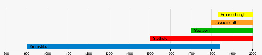
Note: Stotfield is known to exist in the 1500s from old maps, but it is probably even older. Kinneddar is mentioned in the 900s.
Lossiemouth's Natural World
Geography and Geology

Lossiemouth is on the northernmost point of the south coast of the Moray Firth. The River Lossie flows through the town. To the west, there is a sandy beach, golf courses, and the Royal Air Force base, RAF Lossiemouth. Lossie Forest, a large pine forest, starts at the town's edge. The fertile plains of the Laich o' Moray are to the south.
Much of the town is built on Coulard Hill. This hill is made of light grey and yellow sandstone. In this rock, scientists have found many fossils of reptiles from the late Triassic Period. This quarry is one of Britain's most important fossil sites from that time. They found eight different species and 97 individual fossils! Five of these species are found only in Lossiemouth, including an early type of dinosaur.
Wildlife in Lossiemouth
Lossiemouth Beach has large sand dunes. The River Lossie separates it from the town, creating a calm area of water. You can often see many birds feeding under the bridge from the promenade street. These include Ringed plover, grey heron, black-headed gull, oystercatcher, curlew, and mallard. Many other water birds live further east.
Lossiemouth's Climate
| Climate data for Lossiemouth (6m elevation) 1991–2020 | |||||||||||||
|---|---|---|---|---|---|---|---|---|---|---|---|---|---|
| Month | Jan | Feb | Mar | Apr | May | Jun | Jul | Aug | Sep | Oct | Nov | Dec | Year |
| Mean daily maximum °C (°F) | 6.9 (44.4) |
7.6 (45.7) |
9.3 (48.7) |
11.7 (53.1) |
14.1 (57.4) |
16.3 (61.3) |
18.6 (65.5) |
18.4 (65.1) |
16.3 (61.3) |
12.9 (55.2) |
9.5 (49.1) |
7.1 (44.8) |
12.4 (54.3) |
| Mean daily minimum °C (°F) | 0.6 (33.1) |
0.8 (33.4) |
2.0 (35.6) |
3.9 (39.0) |
6.2 (43.2) |
9.1 (48.4) |
10.9 (51.6) |
10.7 (51.3) |
8.9 (48.0) |
5.9 (42.6) |
3.0 (37.4) |
0.5 (32.9) |
5.2 (41.4) |
| Average rainfall mm (inches) | 49.8 (1.96) |
45.4 (1.79) |
40.2 (1.58) |
40.8 (1.61) |
50.3 (1.98) |
58.4 (2.30) |
61.5 (2.42) |
68.9 (2.71) |
67.2 (2.65) |
73.3 (2.89) |
61.1 (2.41) |
53.7 (2.11) |
670.6 (26.40) |
| Average rainy days (≥ 1.0 mm) | 12.0 | 10.3 | 10.5 | 9.6 | 10.2 | 11.8 | 11.3 | 12.0 | 11.3 | 13.0 | 12.8 | 12.1 | 137.0 |
| Source: Met Office | |||||||||||||
People of Lossiemouth
Lossiemouth had a population of 6,873 people in 2001. Most people (73.58%) were born in Scotland, and many (19.83%) were born in England. The largest religious group is the Church of Scotland (41.96%), followed by those with no religion (30.21%).
Lossiemouth's Economy
The Royal Air Force base, RAF Lossiemouth, is very important for jobs in the town. In 2005, the RAF base helped the local economy by a lot of money and provided many jobs. About 21% of all jobs in the area are linked to the base.
Before the RAF, fishing was almost the only big industry in Lossiemouth. Now, fishing is a much smaller part of the economy. However, some engineering businesses that used to support the fishing industry still exist. Lossiemouth does not have many large supermarkets because Elgin, a bigger town nearby, provides many jobs and shopping options.
Getting Around Lossiemouth
Three main roads lead into Lossiemouth. The A941 connects to Elgin. The B9103 joins the main A96 route (between Inverness and Aberdeen). The B9040 connects to Hopeman and Burghead. There is a regular bus service to and from Elgin.
The closest train station is in Elgin. From there, you can catch trains to Inverness and Aberdeen, and then to the rest of the UK. For air travel, Inverness Airport and Aberdeen Airport offer many flight destinations.
Learning in Lossiemouth
Primary Schools
- St Gerardine’s Primary School
- Hythehill Primary School
Secondary School
- Lossiemouth High School is located in the southwest of the town. Next to the school is a swimming pool and community center. Lossiemouth High serves students from Lossiemouth itself and nearby villages like Hopeman, Burghead, Cummingston, and Duffus. In March 2020, there were about 500-600 students.
Further Education
- Ecosse Performers College is located at 56 High Street.
Places of Worship
Lossiemouth has several churches for different Christian groups:
- Church of Scotland: St Gerardine's High, Drainie Parish Church, St James’ Church
- United Free Church of Scotland: United Free Church
- Baptist: Lossiemouth Baptist Church
- Plymouth Brethren: Gospel Hall
- Scottish Episcopal: St Margaret’s Church
- Roman Catholic: St Columba's Church
Fun and Culture in Lossiemouth

- Lossiemouth Cruising Club: For boating enthusiasts at the marina.
- Moray Golf Club: Has two 18-hole golf courses.
- The Warehouse: A small theatre and live music venue.
- Lossiemouth Fisheries and Community Museum: Learn about the town's fishing history.
- Public Library: Located in Town Hall Lane.
- Swimming Pool: Next to Lossiemouth High School.
- Covesea Lighthouse: You can visit this historic lighthouse.
- RAF and FAA Heritage Centre: Learn about the Royal Air Force and Fleet Air Arm at Covesea Lighthouse.
Sports in Lossiemouth

The town's main football team is Lossiemouth F.C., also known as "The Coasters." They play in the Highland Football League at Grant Park. They have won several trophies. The local junior football club is Lossiemouth United. RAF Lossiemouth also has its own sports teams, including football, rugby union, cricket, and rugby league.
The Moray Golf Club has two courses. The "Old Course" was designed in 1889 by Old Tom Morris, who thought it would be the best in the north. The "New Course" was opened in 1979.
Lossiemouth's Language
Lossiemouth, like most of Scotland, used to speak Scottish Gaelic. Later, it adopted a form of the Scots language, similar to the Doric dialect spoken in nearby Aberdeenshire. However, today, standard Scottish English is mostly spoken.
The local Scots dialect is becoming less common. This is partly because Lossiemouth is no longer a major fishing port, where Scots was widely used. Also, many people work at the RAF base and are not from Scotland, which has sped up this change. Some old Scots words are still used, but Scottish English is becoming more common among locals.
Sister City
Lossiemouth is twinned with Hersbruck in Bavaria, Germany. They have been sister cities since 1972.
Famous People from Lossiemouth
Many notable people have come from Lossiemouth:
- James Ramsay MacDonald (1866–1937) – The first British Labour Prime Minister.
- Malcolm MacDonald (1901–1981) – A Labour Member of Parliament, minister, diplomat, and writer.
- Sergeant Alexander Edwards, VC (1885–1918) – A brave soldier who won the Victoria Cross.
- Gordon Campbell, Baron Campbell of Croy (1921–2005) – A soldier, diplomat, Conservative MP, and Cabinet Minister.
- Stewart Imlach (1932–2001) – A professional footballer.
- Alan Main – A professional footballer and Scotland goalkeeper.
- David West, RSW (1868–1936) – A watercolour artist, gold prospector, and sailor.
- Meg Farquhar (1910–1988) – The first female professional golfer in Britain.
- Jock Garden (1882–1968) – A Baptist minister and Australian politician. He helped start the Australian Communist Party.
- George Fraser – A leading expert in growing rhododendrons in British Columbia, Canada.
- Sir Alex Smith (1922–2003) – Former Head of Advanced Research at Rolls-Royce.
- Peter Kerr – A jazz musician, farmer, record producer, and author.
- Very Rev Lewis Gordon (c.1750-c.1820) – A church leader who was Moderator of the General Assembly of the Church of Scotland in 1815.
Interesting Facts About Lossiemouth
Two Royal Navy ships, both named after the River Lossie, helped rescue people during Second World War after torpedo attacks.
- HMS Lossie, a frigate, rescued 112 crewmen in the Indian Ocean in 1944.
- HMS River Lossie (a converted fishing boat) rescued the captain and 41 crew members in 1939 after their merchant ship was sunk by a German U-boat.
Lossiemouth was even mentioned in the TV show Yes, Prime Minister! One character, Bernard Woolley, mistakenly thought it was a type of dog food.
