
Beauly Firth facts for kids
Quick facts for kids Beauly Firth |
|
|---|---|
.jpg)
A view of the Kessock Bridge, crossing the Beauly Firth, 2012
|
|

Beauly Firth
Location in Highland
|
|
| Location | Scotland, United Kingdom |
| Coordinates | 57°29′58″N 4°13′49″W / 57.49944°N 4.23028°W |
| Native name | Linne Fharair Error {{native name checker}}: parameter value is malformed (help) |
| Primary inflows | River Beauly |
| Primary outflows | Moray Firth |
| Max. length | 6.8 mi (10.9 km) |
| Max. width | 2.2 mi (3.5 km) |
The Beauly Firth (in Scottish Gaelic: Linne Fharair) is a long, narrow arm of the sea in northern Scotland. It's like a sea loch or a wide river mouth. The firth is where the River Beauly and River Ness flow into the sea.
At its western end, you'll find the town of Beauly. To the east, it meets Inverness and then flows into the larger Moray Firth. Other smaller streams, like the Moniack and Redcastle Burns, also join the Beauly Firth. The Caledonian Canal connects here too.
When the tide is low, you can see wide, flat areas of mud along the north and west shores. These areas also have scattered rocks. A common bird you might spot here is the goosander, a type of duck.
Contents
Exploring the Beauly Firth
The Beauly Firth is a great place for outdoor activities.
The Kessock Bridge
In 1982, a big bridge called the Kessock Bridge was opened. It connects North Kessock and South Kessock. This bridge is part of the A9 road. It was the first time Inverness was directly linked to the Black Isle. Before the bridge, people used the Kessock Ferry to cross the firth. The ferry had been running since the 15th century!
Cycling and Scenery
The roads around the Beauly Firth are very popular for cycling. It's a lovely route to ride your bike. However, the A862 road on the south side can get quite busy. This makes cycling a bit harder during peak times.
While there are no sandy beaches, the firth has pebbled shores. These are perfect for stone skipping! Many artists also love to visit the firth to paint the beautiful sunsets.
Flooding Concerns
Sometimes, the Beauly Firth can flood. This happens especially after a lot of rain. Communities along the shore, like Bunchrew and Redcastle, can be affected. For example, there was significant flooding during Storm Ciara in 2020.
Another Name for the Firth
The Beauly Firth has another name in Scottish Gaelic: Poll an Ròid. This means "Pool of the Cross". This name is mostly used on Scotland's west coast. It refers to a cross that was put up by friars from Inverness on a small island in the firth.
History of the Beauly Firth
The Beauly Firth has a long and interesting history.
Ancient Ice and Landforms
Scientists have studied the area around Munlochy, a nearby place. They believe that the Beauly Firth was once covered by a huge glacier. This glacier was about 55 meters (180 feet) tall! When the Last Glacial Period ended, the ice slowly melted away. This left behind the firth and the steep hills you see today.
Old Burial Sites
You can find several ancient stone structures called cairns in the Beauly Firth area. At least one of these cairns is said to contain old timber and even human remains.
Roman Times
Around AD 150, during the time of the Roman Empire, a geographer named Ptolemy wrote about the British Isles. In his book, Geography, he might have called the Beauly Firth the "Varar estuary". A Scottish expert, William J. Watson, agrees with this idea.
Fishing Disputes
In the late 1800s, there was a disagreement among fishermen. Fishermen in the Moray Firth were upset. They believed that too much "garvie" (young sprat fish) were being caught in the Beauly Firth. Young garvie fish spend their winters there. The Moray fishermen thought this was causing a drop in their herring fish stock. Because of this, some people wanted to stop garvie fishing in the Beauly Firth.
Images for kids
-
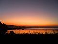
Sunset over the Beauly Firth, viewed from its southern shore
-
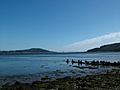
Beauly Firth looking towards the Kessock Bridge, seen in the distance
-
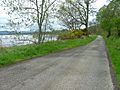
Road running along the north shore of the Beauly Firth, from Beauly to North Kessock


