
Caledonian Canal facts for kids
Quick facts for kids Caledonian |
|
|---|---|

Swing bridge over the Caledonian Canal
|
|
| Specifications | |
| Maximum boat length | 150 ft 0 in (45.72 m) |
| Maximum boat beam | 35 ft 0 in (10.7 m) |
| Locks | 29 |
| Status | Navigable |
| Navigation authority | Scottish Canals |
| History | |
| Original owner | Caledonian Canal Commissioners |
| Principal engineer | Thomas Telford |
| Date of act | 1803 |
| Date completed | 1822 |
| Geography | |
| Start point | Inverness |
| End point | Fort William |
The Caledonian Canal is a famous waterway in Scotland. It connects the east coast at Inverness with the west coast near Fort William. This amazing canal was built in the early 1800s by a Scottish engineer named Thomas Telford. It's a special route that lets boats travel across Scotland without having to go all the way around the dangerous northern coast.
Contents
What is the Canal's Route?
The Caledonian Canal stretches about 60 miles (97 km) from the northeast to the southwest. It reaches 106 feet (about 32 meters) above sea level at its highest point.
What makes this canal unique is that only one-third of it was actually dug by people. The rest of the route uses natural lakes, called "lochs" in Scotland. These include Loch Dochfour, Loch Ness (yes, the one with the monster stories!), Loch Oich, and Loch Lochy. These lochs are found in a long valley called the Great Glen, which sits on a natural crack in the Earth's crust (like a giant fault line).
Along the canal, you'll find 29 locks. Locks are like water elevators that lift or lower boats between different water levels. Eight of these locks are part of a famous section called Neptune's Staircase near Banavie. There are also four aqueducts (bridges that carry water) and 10 bridges that cross over the canal.
How Was the Canal Built?
People started thinking about building a canal here way back in the 1700s. They wanted a safer and shorter way for ships to travel between Scotland's east and west coasts. The journey around the north of Scotland was very dangerous because of strong winds and rough seas.
Early Ideas and Challenges
In 1774, an inventor named James Watt (who helped invent the steam engine!) looked at the idea. He thought a canal would be good for fishing boats and for bringing cheaper food to people. But he also worried about strong winds on the lochs.
Later, in the early 1800s, many people in the Scottish Highlands were losing their homes and jobs. This was due to something called the Highland Clearances, where landowners changed their farms from cattle to sheep. This meant fewer jobs for people.
The famous engineer Thomas Telford was asked to help. He suggested building roads, bridges, and canals. This would create jobs and help the local economy. Ship owners really liked the idea of a canal because it would protect their ships from bad weather and even from French privateers (pirates working for a government) during wartime.
Building the Great Canal
The British Parliament officially approved the canal project in 1803. They provided money to start the work. Thomas Telford was put in charge of designing and building the waterway. He worked with another engineer, William Jessop.
Building the canal was a huge challenge! The area was very remote, so they started building from both ends at once. This way, they could use the finished parts to bring in materials for the middle sections.
One of the biggest problems was the ground itself. At one end, they had to build the entrance lock on solid rock. But at the other end, there was 56 feet (about 17 meters) of mud! They had to dump rocks on top of the mud and let it settle for six months before they could even start building.
The locks they built were the largest ever made at that time. It was also hard to find enough workers, especially during harvest times. So, Telford had to bring in workers from Ireland, which caused some complaints because the canal was supposed to help local unemployment.
The canal finally opened in 1822. It took 12 years longer than planned and cost much more money. Even though it was a huge effort, many of the new steam-powered ships were already too big to use the canal. Also, the war with Napoleon had ended, so the Royal Navy didn't need the canal for protection anymore.


How the Canal is Used Today
After it opened, some parts of the canal needed repairs. In 1843, part of a lock at Corpach collapsed. The canal was closed for a few years for major repairs, and it was made deeper at the same time.
The canal didn't become a big success for commercial shipping. However, people soon realized how beautiful the scenery was along its route. It started to become a popular place for tourists!
In 1873, Queen Victoria took a trip along the canal. This brought a lot of attention to the area, and many more visitors came to see it. Even when railways arrived, they didn't hurt the canal much. Instead, train schedules were set up to connect with steamboat services on the canal.
During the First World War, the canal became important again for shipping supplies. It was even open 24 hours a day with lights to guide boats.
Over the years, the canal needed more repairs. Between 1995 and 2005, a big project took place to fix the lock walls and replace all the lock gates. Now, the canal is in better shape than ever!
Today, the Caledonian Canal is a Scheduled Ancient Monument. This means it's a very important historical site. It attracts over 500,000 visitors every year! People can enjoy the canal by cycling along the paths next to it, or by taking boat trips on special hotel barges.
Names of the Canal
The Caledonian Canal has a few names in Scottish Gaelic, the traditional language of Scotland. These include Amar-Uisge/Seòlaid a' Ghlinne Mhòir ("Waterway of the Great Glen") and Sligh'-Uisge na h-Alba ("Waterway of Scotland").
- Locks along the Caledonian Canal
-
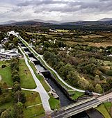
Neptune's Staircase, the longest staircase lock in Britain.
-
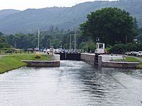
The Dochgarroch Lock along the Caledonian Canal with its lower gates open. The upper gates leading to Loch Dochfour are closed.
-
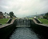
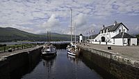
Locks on the Caledonian Canal at Fort Augustus
-
Gairlochy Bottom Lock
-
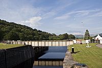
Corpach sea lock
-
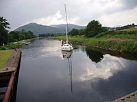
A sailingboat on the Caledonian Canal approaches from the Loch Linnhe side of the Mallaig Extension Railway swing bridge.
-
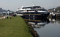
Lord of the Glens leaving Corpach Sea Lock


Points of interest
| Point | Coordinates (Links to map resources) |
OS Grid Ref | Notes |
|---|---|---|---|
| Clachnaharry Sea Lock, Inverness | 57°29′26″N 4°15′46″W / 57.4906°N 4.2628°W | NH644467 | |
| Muirtown Locks, Inverness | 57°28′51″N 4°14′56″W / 57.4807°N 4.2490°W | NH652456 | |
| Dochgarroch Lock | 57°25′59″N 4°18′08″W / 57.4330°N 4.3023°W | NH618404 | |
| Entrance to Loch Ness | 57°24′28″N 4°19′43″W / 57.4077°N 4.3285°W | NH602376 | |
| Fort Augustus Locks | 57°08′41″N 4°40′59″W / 57.1447°N 4.6831°W | NH377091 | |
| Kytra Lock | 57°07′21″N 4°43′22″W / 57.1224°N 4.7229°W | NH352067 | |
| Cullochy Lock | 57°05′52″N 4°44′23″W / 57.0979°N 4.7397°W | NH341041 | |
| Laggan Locks | 57°01′33″N 4°49′31″W / 57.0259°N 4.8254°W | NN286963 | |
| Gairlochy Top Lock | 56°54′53″N 4°59′38″W / 56.9146°N 4.9940°W | NN178843 | |
| Neptune's Staircase, Banavie | 56°50′47″N 5°05′37″W / 56.8465°N 5.0935°W | NN114770 | |
| Corpach Locks | 56°50′31″N 5°07′23″W / 56.8420°N 5.1231°W | NN096766 |
Images for kids
-
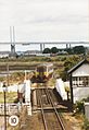
A British Rail Class 156 train crossing over the canal on the Clachnaharry Swing Bridge.
.jpg)
See also
 In Spanish: Canal de Caledonia para niños
