
Ben More Assynt facts for kids
Quick facts for kids Ben More Assynt |
|
|---|---|

Ben More Assynt from Conival.
|
|
| Highest point | |
| Elevation | 998 m (3,274 ft) |
| Prominence | 835 m (2,740 ft) Ranked 26th in British Isles |
| Parent peak | Sgurr Mor |
| Listing | Munro, Marilyn, County top (Sutherland) |
| Naming | |
| English translation | Big mountain of Assynt |
| Language of name | Gaelic |
| Geography | |

Ben More Assynt
Location in Sutherland
|
|
| Parent range | Northwest Highlands |
| OS grid | NC317201 |
| Topo map | OS Landranger 15, OS Explorer 442 |
Ben More Assynt (which means "Big mountain of Assynt" in Gaelic) is a tall mountain in the far north-west of Scotland. It's about 30 kilometers (19 miles) north-northeast of Ullapool. Standing at 998 meters (3,274 feet) high, it's the highest point in the area called Sutherland.
This mountain is in the eastern part of Assynt. It's not as famous as some other mountains nearby, like Suilven, even though Ben More Assynt is taller. You can't easily see it from the main A837 road because another mountain, Conival, blocks the view. The best way to see Ben More Assynt is from the tops of other nearby mountains. The higher parts of Ben More Assynt are covered in light-colored quartzite rocks, which makes it look very unique.
More than 90 square kilometers (35 square miles) of land around Ben More Assynt is a special protected area. It's called a Site of Special Scientific Interest (SSSI). This is because of its interesting geology (the study of rocks and how the Earth is made) and the rare plants that grow there.
Contents
Where is Ben More Assynt?
Ben More Assynt is on a high ridge of land that runs north to south. This ridge is on the east side of the A837 road, close to a place called Inchnadamph. This area is part of Scotland's main watershed. This means that rain falling on one side of the mountain flows to the North Sea. Rain falling on the other side flows to the Atlantic Ocean.
The eastern and southern parts of the mountain send their water into the River Oykel. This river then flows into the Dornoch Firth on Scotland's east coast. Water from the western side of the mountain flows through Loch Assynt. It then reaches the Atlantic Ocean at Lochinver.
Ben More Assynt is connected to a nearby peak called Conival. They are joined by a high ridge. Because Conival is usually climbed first when starting from Inchnadamph, people often climb both mountains together. Ben More Assynt also has a smaller peak called the South Top. It's about one kilometer (0.6 miles) south of the main summit and is 960 meters (3,150 feet) high.
What is Ben More Assynt Made Of?
The Assynt area is famous for its special geology. It's part of the Moine Thrust Belt. This is a place where huge layers of rock have been pushed over each other. Ben More Assynt and Conival sit on a large "thrust sheet" of rock. This sheet is made of very old rocks called Lewisian gneiss. It also has layers of Torridonian sandstone and Cambrian quartzite.
The Lewisian gneiss rocks can be seen south and southeast of Ben More Assynt's main peak. This makes the South Top the highest place where this type of rock is found. The very top of Ben More Assynt is made of Cambrian quartzite. This rock also forms the ridge leading to Conival.
How to Climb Ben More Assynt
Most people who climb Ben More Assynt also climb Conival. The usual starting point is the small village of Inchnadamph. From there, the path follows the River Traligill. It goes up to a high pass between Conival and Beinn an Fhurain. This pass is about 750 meters (2,460 feet) high.
After that, it's a tough climb over broken quartzite rocks to reach the top of Conival. Ben More Assynt's summit is about 1.5 kilometers (0.9 miles) to the east. The walk between the two peaks is challenging. You have to walk over many quartzite stones and loose rock. The very top of Ben More Assynt is marked by a broken piece of quartzite rock. Be careful on the sharp ridge, especially if it's wet.
Plants and Animals
Ben More Assynt is home to many rare and special plants. There are four types of plants here that are on the World Conservation Union’s (IUCN) Red List. This list shows species that are in danger of disappearing. Also, there are 27 types of plants that are nationally scarce within the protected area.
In the past, there was a plan to build a large wind farm about 22 kilometers (14 miles) southeast of the mountain. People who were against the wind farm said it would spoil the beautiful views from Ben More Assynt. They also felt it would make the area feel less wild and natural. The future of this plan is still being discussed.
A Special Memorial
During the Second World War in April 1941, a plane crashed on Ben More Assynt. All six crew members on board the Avro Anson aircraft died. Because the crash site was so hard to reach, the crew were buried right there on the mountain. A pile of stones, called a cairn, marked their graves.
In 2012, the Commonwealth War Graves Commission decided to replace the old cairn. The harsh weather had damaged it over time. They put in a new, strong granite marker that weighed 600 kilograms (1,323 pounds). This new memorial helps to identify and protect the burial site.
The burial site on Ben More Assynt is about 610 meters (2,000 feet) high. It's one of the most remote grave sites in the UK. Getting the heavy granite memorial up the mountain was very difficult. Finally, a large Chinook helicopter from RAF Odiham had to carry the memorial to the site. The granite memorial now marks the spot where Pilot Officer William Drew, Sergeant Jack Emery, Sergeant Harold Arthur Tompsett, Flying Officer James Henry Steyn, Sergeant Charles McPherson Mitchell, and Flight Sergeant Thomas Brendon Kenny lost their lives.
Gallery
-
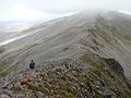
Ben More Assynt seen from Conival.
-
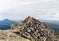
The broken quartzite rocks at the top of Ben More Assynt.


See also
 In Spanish: Ben More Assynt para niños
