Conival facts for kids
Quick facts for kids Conival |
|
|---|---|
| Scottish Gaelic: Cona Mheall | |

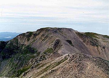
Conival seen from Ben More Assynt.
|
|
| Highest point | |
| Elevation | 987 m (3,238 ft) |
| Prominence | 101 m (331 ft) |
| Listing | Munro |
| Naming | |
| English translation | Adjoining Hill or Hill of Meeting |
| Language of name | Gaelic |
| Geography | |
| Location | Assynt, |
| Parent range | Northwest Highlands |
| OS grid | NC303199 |
| Topo map | OS Landranger 15, OS Explorer 442 |
Conival is a Scottish mountain found in a beautiful area called Assynt. It's located in the Sutherland part of the Highland Council Area. The mountain is about 30 kilometers (19 miles) north-east of the town of Ullapool. Its name in Scottish Gaelic is Cona Mheall.
Contents
About Conival
Conival is a mountain that really stands out! When you look at it from the A837 road to the west, you can clearly see its tall western side. This part of the mountain is about 600 meters (2,000 feet) high. It's made of light-colored rock called quartzite.
The mountain reaches a height of 987 meters (3,238 feet). This makes it a Munro, which is a Scottish mountain over 3,000 feet tall. Conival is connected to another famous Munro called Ben More Assynt. A high, rocky ridge links them together. Ben More Assynt is about 1.5 kilometers (0.93 miles) to the east.
Many different people enjoy visiting Conival. It's popular with walkers who love to hike. But it also attracts scientists who study rocks (geologists) and plants and animals (biologists). People who explore caves (speleologists) find it interesting too.
What's in a Name?
The name "Conival" has an interesting history. Unlike many hills in the Assynt area, its name doesn't come from the Norse language. It actually comes from Gaelic.
When Munros were first listed in 1891, Conival was called "Conamheall." This name means "adjoining hill" or "hill of meeting." This makes sense because it's so closely connected to Ben More Assynt. For a while, between 1921 and 1969, it was called "Cona-mheall," which meant "enchanted hill." Since 1974, we've known it by its English name, Conival.
Nature and Rocks
Conival is part of a special area called the Ben More Assynt Site of Special Scientific Interest. This is because it has amazing geological features. You can see the Moine Thrust Belt clearly on its slopes. This is where huge pieces of rock were pushed up by tectonic plates crashing together a very long time ago.
On the lower western side of the mountain, you can find cool limestone pavements. These are flat areas of rock with cracks, found in the valley of the River Traligill. Conival is also part of the North West Highlands Geopark and the Inchnadamph National Nature Reserve. The limestone here helps rare plants grow, like mountain avens, frog orchid, and holly fern.
Mountain Shape and Water
Conival has a main ridge that runs from north-west to south-east. This ridge connects to a smaller peak called Beinn an Fhurain. Its highest point is known as Na Tuadhan (852 meters). Na Tuadhan is important for geology because it shows amazing folds in the quartzite rock.
Water from Conival's slopes flows in two different directions! This mountain sits on Scotland's main east-west watershed. Water from the southern slopes flows into the River Oykel, which goes to the Dornoch Firth on the eastern coast. Streams on the northern side also flow east to the Dornoch Firth through Loch Shin. But water from the western slopes drains into the River Traligill. This river flows west through Loch Assynt and eventually reaches the sea at Lochinver.
Climbing Conival
The most common way to climb Conival starts at a place called Inchnadamph. You can find parking near the Inchnadamph hotel. The path follows the valley of the River Traligill. Along the way, you'll pass the Cnoc nan Uamh cave system. These caves are about 1.4 kilometers (0.87 miles) long. They show the earliest signs of people living in Scotland, from around 6000 BC!
The path continues up to where the river starts, between Beinn an Fhurain and Conival. From there, it's a rough climb over loose quartzite rocks to the summit. Most walkers then continue their adventure to Ben More Assynt, which is about 1.5 kilometers (0.93 miles) further east.
The Summit View
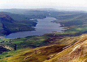
The top of Conival is a rocky area made of quartzite. You'll find a large circular stone shelter there, built around the remains of an OS trig point. From the summit, you get an amazing view to the west. You can see other mountains like Quinag, Canisp, and Cul Mor. You also get a great view of Loch Assynt.
 | Aaron Henry |
 | T. R. M. Howard |
 | Jesse Jackson |


