Canisp facts for kids
Quick facts for kids Canisp |
|
|---|---|
| Canasp | |

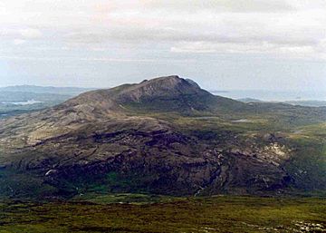
Canisp seen from Conival, nine kilometres to the east.
|
|
| Highest point | |
| Elevation | 847 m (2,779 ft) |
| Prominence | 691 m (2,267 ft) Ranked 65th in British Isles |
| Parent peak | Ben More Assynt |
| Listing | Corbett, Marilyn |
| Naming | |
| English translation | White Mountain |
| Language of name | Old Norse |
| Geography | |
| Location | Assynt, Scotland |
| Parent range | Northwest Highlands |
| OS grid | NC203187 |
| Topo map | OS Landranger 15, OS Explorer 442 |
Canisp (in Scottish Gaelic it's Canasp) is a cool mountain in the far northwest of Scotland. It's located in a place called Assynt, in the area of Sutherland. Canisp is about 25 kilometres north of the town of Ullapool.
This mountain stands 847 metres (about 2,779 feet) tall. It's known as a Corbett and a Marilyn. These are special lists of mountains based on their height and how much they rise above the land around them. The name Canisp comes from the Old Norse language and means “White Mountain”.
Contents
What is Canisp Like?
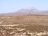
Canisp is a mountain that stands pretty much by itself. It's in a wild area called Glencanisp Forest, which has lots of rocks and water. The mountain rises 691 metres (2,280 feet) from the land around it. This is called its topographic prominence.
Rocks and How Canisp Formed
Canisp doesn't have much plant life. You can see large areas of rock on its lower slopes. These rocks are called Gneiss, and they are some of the oldest rocks on Earth!
Canisp is in a very important geological area. It's part of the Moine Thrust Belt. This means the rocks here were pushed and moved a lot over millions of years. Canisp is like many other hills in Assynt. It starts with Lewisian Gneiss at its base. Then it has Torridonian sandstone, and on top, it's covered by Cambrian quartzite. This gives the mountain a unique light grey top.
Canisp was formed during a time when glaciers covered much of the land. The ice sheets eroded (wore away) the rocks around it. But Canisp was left sticking out above the ice, like an island in a sea of ice. This kind of peak is called a nunatak.
Canisp's Shape and Surroundings
Canisp has a balanced shape, with two main ridges. One ridge goes northwest, and the other goes southeast. The southwest side of the mountain has steep cliffs and loose rocks called scree. It drops sharply into Glen Canisp. The northeast side also drops steeply down to lochans (small lakes) and open moorland.
Canisp is not as busy as Suilven, a smaller mountain nearby. Suilven is about five kilometres to the west and is 116 metres shorter. But Suilven is more popular because of its jagged, spiky top.
How to Climb Canisp

The most common way to climb Canisp starts at the north end of Loch Awe (NC249160). There's a place to park your car there. You cross the River Loanan using a footbridge.
The path then goes up the southeast ridge to the top. This is the quickest way, but it's still about 6 kilometres long. There aren't many clear paths, so you'll walk over rocks, heather, and boggy ground. Another way to start from the east is at Stronchrubie, where there's also a footbridge.
You can also start longer climbs from Lochinver or Ledmore Junction. These routes use a path that goes through Glen Canisp. Then you leave the glen to climb the mountain. From Lochinver, you'd climb the northwest ridge. From Ledmore, you'd use the southeast ridge. The route from Lochinver, which goes via Loch na Gainimh, is thought to be the most enjoyable way up.
At the very top of Canisp, you'll find a large stone shelter built to protect you from the wind. The views from the summit are amazing! You can see the many lochs and moorland all around. You can also see The Minch (a sea strait) beyond Lochinver. Plus, you get to see most of the famous mountains in Assynt.
 | Delilah Pierce |
 | Gordon Parks |
 | Augusta Savage |
 | Charles Ethan Porter |


