
Oldany Island facts for kids
| Meaning of name | fruit |
|---|---|
| OS grid reference | NC088345 |
| Coordinates | 58°16′N 5°16′W / 58.26°N 5.26°W |
| Physical geography | |
| Island group | Highland / Islands of Sutherland |
| Area | 200 ha |
| Area rank | 109 |
| Highest elevation | Sidhean nan Ealachan 104 m |
| Administration | |
| Sovereign state | United Kingdom |
| Country | Scotland |
| Council area | Highland Council |
| Demographics | |
| Population | 0 |
Oldany Island is a small, quiet island located in the north-west of Scotland. It's part of an area called Assynt in Sutherland. What makes Oldany Island special is that no one lives there permanently, so it's an uninhabited island.
The name "Oldany" comes from an old language called Norse, which was spoken by Vikings who visited Scotland long ago. The name might mean "fruit," but we're not entirely sure!
Contents
Exploring Oldany Island's Location
Oldany Island is a tidal island. This means that at certain times of the day, when the tide is low, you might be able to walk to it from the mainland. But when the tide comes in, the water covers the path, and it becomes a true island again!
Size and Highest Point
This island covers an area of about 200 hectares. To give you an idea, that's like 200 football fields! The highest point on Oldany Island is a hill called Sìdhean nan Ealachan. This name means "The Swans' Fairy Mound," and it stands about 104 meters (or 341 feet) tall.
Nearby Islands and Features
Oldany Island sits at the entrance to a beautiful area called Eddrachillis Bay. If you look north across the bay, you'll see Handa Island. To the south-west, there's another island called Eilean Chrona. You might also spot Sgeir nan Gall to the north, which means "Norsemen's Skerry." A skerry is a very small, rocky island or a rock in the sea.
A Protected Natural Area
Oldany Island is part of the Assynt-Coigach National Scenic Area. Scotland has 40 of these special areas. They are protected because they have amazing natural beauty and are important for wildlife. This means the landscape around Oldany Island is truly stunning!
Life on Oldany Island
Even though no people live on Oldany Island, it's not completely empty. The island has been used for a very long time for grazing sheep. This means farmers bring their sheep to the island to eat the grass.
The small village of Oldany is located on the mainland, right next to the island. Oldany Island is privately owned by the Turner family.
Images for kids
-
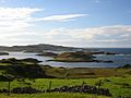
A view of Oldany Island from the mainland, showing many smaller islands nearby.
-
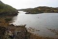
Oldany Island on the right, seen from the mainland on the left.


