Soyea Island facts for kids
| Meaning of name | Sheep island |
|---|---|
 |
|
| OS grid reference | NC0465521990 |
| Coordinates | 58°08′36″N 5°19′14″W / 58.143442°N 5.3206176°W |
| Physical geography | |
| Area | 20 hectares (0.08 sq mi) |
| Highest elevation | 38m |
| Administration | |
| Sovereign state | United Kingdom |
| Country | Scotland |
| Council area | Highland |
| Demographics | |
| Population | 0 |
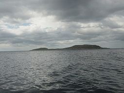
Soyea Island, or just Soyea, is a small, rocky island located in Scotland. You can find it at the entrance of Loch Inver, which is a sea loch in the Highland area. It's about 3 kilometers (2 miles) west of a town called Lochinver.
This island is not very big, measuring about half a mile from east to west. It covers an area of 20 hectares (about 50 acres) and its highest point is 38 meters (125 feet) above sea level. Soyea Island is important because it marks the way into Lochinver's fishing harbor. There's even a yellow light on the island to help guide boats safely, especially at night!
Island's Story
What's in a Name?
The name "Soyea" comes from an old language called Old Norse. It means "Sheep-isle" or "Sea island." This gives us a clue about how the island might have been used a long time ago.
Island Life: Past and Present
In 1881, people recorded Soyea as a "pastoral islet." This means it was likely used for grazing animals, probably sheep, even though it's small and rocky.
In the 1920s, something interesting happened on Soyea Island. It became home to a group of special moths called Abraxas grossulariata, also known as magpie moths. These moths were quite rare on the Scottish mainland at the time. Today, Soyea Island is uninhabited, meaning no people live there. It remains a quiet, rocky spot at the mouth of the loch.
 | Kyle Baker |
 | Joseph Yoakum |
 | Laura Wheeler Waring |
 | Henry Ossawa Tanner |

