Little Bernera facts for kids
| Gaelic name | Beàrnaraigh Beag |
|---|---|
| Norse name | bjarnar-øy |
| Meaning of name | Bjørn's island, from Norse |
| OS grid reference | NB142410 |
| Coordinates | 58°16′N 6°52′W / 58.27°N 6.87°W |
| Physical geography | |
| Island group | Lewis |
| Area | 138 ha |
| Area rank | 129= |
| Highest elevation | Tordal 41 m |
| Administration | |
| Sovereign state | United Kingdom |
| Country | Scotland |
| Council area | Outer Hebrides |
| Demographics | |
| Population | 0 |
Little Bernera (which in Scottish Gaelic is Beàrnaraigh Beag) is a small island. It is located off the west coast of the Isle of Lewis in the Outer Hebrides. This island is quite small, covering an area of 138 hectares. Its highest point, Tordal, reaches about 42 meters (138 feet) above sea level.
Contents
About Little Bernera
Little Bernera sits between two sea lochs, West and East Loch Roag. It is found just north of Great Bernera. Even though it is small, the island has a long history. People have lived there for many centuries.
A Look Back in Time
Little Bernera shows signs of people living there for a very long time. You can still see the remains of old homes and chapels.
Life on the Island
In 1825, the last families living on Little Bernera moved away. The island then became part of a larger farm called Linshader. After the people left, the only building that could still be used was a fish curing-house. This building was used for preparing fish.
Old School and Burial Ground
There was once a school on the island. It was set up by a group called the SSPCK. This group helped spread Christian knowledge.
Many centuries ago, people from the nearby village of Carloway used Little Bernera as a burial place. This was before a cemetery was built in their own village. Today, you can still find old gravestones on the island. However, some are slowly sinking into the ground.
Island Landscape
The island has two very different sides. The western part of Little Bernera is very rough and rocky. It looks quite different from the eastern side.
East vs. West
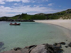
The eastern side of the island has special land called machair. Machair is a fertile grassland found near the coast. It gets its richness from the shell sand blown in from the beaches. This side of the island has two beautiful beaches. They are called Tràigh Mhòr and Tràigh na Teampuill.
At Tràigh an Teampaill, you can find the remains of St Michael's chapel. There is also a cemetery next to it. Another old chapel, St Dondans, was once on the island. No trace of it remains today. People believe it was located in the very north-west, near Mol Mòr.
 | Sharif Bey |
 | Hale Woodruff |
 | Richmond Barthé |
 | Purvis Young |


