
Skigersta facts for kids
Quick facts for kids Skigersta
|
|
|---|---|
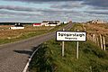
 The road into Skigersta |
|

Skigersta
|
|
| Language | Scottish Gaelic English |
| OS grid reference | NB543616 |
| Civil parish | |
| Council area | |
| Lieutenancy area | |
| Country | Scotland |
| Sovereign state | United Kingdom |
| Post town | ISLE OF LEWIS |
| Postcode district | HS2 |
| Dialling code | 01851 |
| Police | Northern |
| Fire | Highlands and Islands |
| Ambulance | Scottish |
| EU Parliament | Scotland |
| UK Parliament |
|
| Scottish Parliament |
|
Skigersta (which is Sgiogarstaigh in Scottish Gaelic) is a small village. It is located on the Isle of Lewis in the Outer Hebrides, Scotland. You can find it southeast of Ness.
Skigersta is the most eastern village in the Ness area. It is about 5 kilometers (3 miles) southeast of the Butt of Lewis. The village is part of the Barvas parish.
The village has a quay, which is a kind of dock built in 1901. There is also a beach made of small stones, called a shingle beach. The part of Skigersta near the water is known as 'Lachamore'.
South of Skigersta, the land changes into a wide, open area called a moor. The road turns into a path made for walking on peat. You can find old summer huts, called sheilings, on the moor at Cuisiadar. If you keep going south, you will reach the road at New Tolsta.
Skigersta's Past
In the 1800s, Skigersta was a busy place for fish curing. This means they would prepare fish to keep it fresh for a long time. You can still see the old ruins of the buildings, called bothies, where they did this work near the river.
The village also had a special man-made channel built into the shoreline. This channel made it easier for boats to get in and out of the water.
Sadly, a cargo ship named the Dunalistair crashed near Skigersta in 1885. This happened during foggy weather.
Creag Dubh: The Black Crag
Southeast of Skigersta, there is a small piece of land sticking out into the sea. It is called Creag Dubh, which means 'the black crag'. On this land, you can find a pile of stones called a cairn. There are also possible remains of an old roundhouse.
Archaeologists studied this site in the 2000s. They were worried that the sea would wash away the site within the next ten years.
Skigersta in Books
The village of "Crobost" in the famous Lewis Trilogy books by Peter May is believed to be a mix of two real villages. These are Adabroc and Skigersta.
Images for kids
-
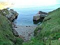
The pier at Skigersta
-
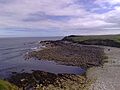
The shore at Skigersta
-
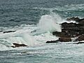
Waves crashing at Port Sgiogarstaigh
-
The village of Skigersta


