
Beinn Eighe facts for kids
Quick facts for kids Beinn Eighe - Ruadh-stac Mòr |
|
|---|---|
.jpg)
Beinn Eighe from west of Kinlochewe.
|
|
| Highest point | |
| Elevation | 1,010 m (3,310 ft) |
| Prominence | 632 m (2,073 ft) |
| Parent peak | Liathach |
| Listing | Munro, Marilyn |
| Naming | |
| English translation | Big Red Stack |
| Language of name | Gaelic |
| Geography | |
| Location | Torridon Hills, Scotland |
| OS grid | NG951611 |
| Topo map | OS Landranger 19 |
Beinn Eighe is a large and interesting mountain in the Torridon Hills area of Scotland. It's located in the Highlands, south of Loch Maree. This mountain forms a long ridge with many smaller peaks. Two of its summits are known as Munros, which are Scottish mountains over 3,000 feet (914.4 meters) high.
The name Beinn Eighe comes from the Scottish Gaelic words meaning File Mountain. This is because its peaks look like the teeth of a file. Unlike many other mountains nearby, Beinn Eighe has a special cap of white rock called quartzite. This gives its peaks a unique light color. Because of its interesting shape, Beinn Eighe is a popular spot for both hillwalking and climbing. It also has a national nature reserve on its northern side, making it easy for visitors to explore.
Contents
Exploring Beinn Eighe's Geography

Beinn Eighe is a complex mountain located on the west coast of Scotland. It sits between Loch Maree and Glen Torridon. The main part of the mountain stretches from near the village of Kinlochewe in the northeast. It goes all the way to a narrow valley called Coire Dubh Mòr. This valley separates Beinn Eighe from its neighbor, Liathach.
The southern side of Beinn Eighe, facing Glen Torridon, has very steep slopes. These slopes are covered in white quartzite rocks that have broken off. On the northern side, there are four large bowl-shaped valleys called corries. Between these corries are ridges that stick out from the main mountain. The southern and eastern parts of the mountain are close to main roads. However, the northwest area is mostly wild mountains and forests.
Who Owns Beinn Eighe?
The eastern part of Beinn Eighe is owned by NatureScot. They manage it as a national nature reserve. The rest of the southern side belongs to the National Trust for Scotland. This area is also part of the nature reserve. The northwestern part of Beinn Eighe is within the Grudie & Talladale Estate.
Beinn Eighe's Main Peaks
Beinn Eighe has two summits that are classified as Munros.
- Ruadh-stac Mòr is the highest point of Beinn Eighe. Its name means 'Big Red Stack' in Scottish Gaelic. It stands at 1,010 meters (3,314 feet) high. This peak is on one of the ridges that branch off the main mountain.
- Spidean Coire nan Clach is the second Munro on Beinn Eighe. Its name means 'Peak of the Corrie of Stones'. It is 993 meters (3,258 feet) high. This peak is the highest point on the main ridge itself. From here, you can see amazing views over Glen Torridon and the rest of Beinn Eighe.
There is also another peak called Ruadh-stac Beag. It is 896 meters (2,940 feet) high. It is known as a Corbett, which is another type of Scottish mountain.
The Famous Triple Buttress Corrie
One of the most famous parts of Beinn Eighe is the corrie called Coire Mhic Fhearchair. People often call it the "Triple Buttress Corrie." This is because of the three huge rock faces that you can see from the north. These buttresses are popular for rock climbing. Hillwalkers can also reach the top of these buttresses from the back of the corrie.
Beinn Eighe's Ancient Geology
The rocks under Beinn Eighe are very old. They are made of Lewisian gneiss, which is one of the oldest rock types on Earth. On top of this, there is younger rock called Precambrian Torridonian Sandstone. This sandstone forms most of the Torridon Hills, including Beinn Eighe. It was made about 800 million years ago from river sediments.
What makes Beinn Eighe special is its summit ridge. It is made of white Cambrian basal quartzite. This rock is very hard but also brittle. It formed about 540 million years ago from pure white sands. At that time, the area was covered by warm tropical seas. The quartzite gives Beinn Eighe its light-colored peaks. They stand out from other mountains and can even look like snow.
Scientists have found a special rock layer within the Cambrian rocks called the Fucoid Beds. The fossils found here are different from those in rocks of the same age in England. This helped scientists realize that during the Cambrian period, Scotland and England were separated by an ocean. These fossils include ancient sea creatures like trilobites and worm burrows. They are some of the oldest fossils found in Scotland. One creature, Olenellus armatus, has only been found in the rocks of Beinn Eighe.
Over many years, huge sheets of ice called glaciers shaped the area during different ice ages.
Amazing Plants and Animals

Beinn Eighe is home to many rare plants. This includes different types of dwarf shrubs and mosses. In total, 680 different plant species have been found here. It has the most types of oceanic mosses and liverworts of any single place in Britain. A rare liverwort called Herbertus borealis (northern prongwort) is only found on the summit plateau of Beinn Eighe in Britain. Also, a moss called Daltonia splachnoides has been found here, which is its most northern known location in the world. Other rare plants include tufted saxifrage and brook saxifrage.
About 235 hectares of the Beinn Eighe National Nature Reserve are covered in ancient woodlands. The woodland at Coille na Glas Leitir is the largest part of the old Caledonian pinewood left in northwest Scotland. The Scots pine trees here are genetically different from those in eastern Scotland. They are more like pines found in southern Europe. Scientists think this is because western Scotland became free of ice first after the last ice age. This allowed pines to spread north along the western coast of Europe. Pines reached Eastern Scotland later, as the ice sheets melted further. In 2019, a "genetic reserve" was set up at Beinn Eighe. This helps study and protect the special DNA of these unique pine trees.
Many bird species live at Beinn Eighe. You might see golden eagles, Scottish crossbills, bramblings, ring ouzels, golden plovers, skylarks, redwings, and divers. The reserve is also home to mammals like red deer, mountain hare, and pine martens. Otters live along the shores of Loch Maree. They have even been seen in streams and small lakes up to 400 meters (1,312 feet) high on the mountain.
Climbing and Walking on Beinn Eighe

Beinn Eighe's varied landscape offers many routes for both walkers and climbers. For those who enjoy hillwalking, a popular path is the western traverse. This route includes both of the Munro summits and goes past Coire Mhic Fhearchair.
A full journey across Beinn Eighe involves going over a series of rocky peaks called the Black Carls. These peaks are at the eastern end of the main ridge. They offer good scrambling, which is like climbing but without ropes. The Black Carls are also a popular climb on their own, especially when approached from the east.
People have been exploring this area for a long time. The mapmaker Timothy Pont visited the Loch Maree area in the late 1500s. He even drew a sketch of Coire Mhic Fhearchair on his maps. However, there isn't much record of anyone reaching the summits of Beinn Eighe before the 1800s. The first recorded climb seems to have been in 1851. This was when a surveyor named George Campbell Smith was mapping the boundary between two large estates.
The 1951 Air Crash

The Triple Buttress Corrie was the site of an airplane crash on March 13–14, 1951. An Avro Lancaster aircraft crashed about 5 meters (16 feet) below the top of the summit ridge. It landed in a gully now called Fuselage Gulley. The plane was part of 120 Squadron and had taken off from RAF Kinloss for a mission over the sea. The weather was very bad during its return, with freezing temperatures and strong winds.
It took two days for the crash site to be found, even with planes searching. The RAF rescue teams arrived at the mountain's base on March 17. However, they faced very difficult conditions and couldn't reach the crash site. Finally, two Royal Marine commandos managed to get there. It took almost six months to recover the bodies of the eight crew members.
This difficult recovery operation led to important changes. It helped create formal training courses for the RAF Mountain Rescue Teams. Before this, rescue teams were not fully trained or equipped for such extreme mountain rescues. It also led to the creation of a new role in the Air Ministry to oversee land rescues. Local gamekeepers and gillies also helped. Their involvement was key in forming the Kinlochewe and Torridon Mountain Rescue Team.
The eight crew members who died in the incident were:
- Fl/Lt Harry Smith Reid DFC (29), Pilot, RAF.
- Sgt Ralph Clucas (23), Co-Pilot, RAF.
- Flt Lt Robert Strong (27), Navigator, RAF.
- Fl/Lt Peter Tennison (26), Air Signals, RAF.
- Sgt James Naismith (28), Air Signals, RAF.
- Sgt Wilfred D Beck (19), Air Signals, RAF.
- Sgt James W Bell (25), Air Signals, RAF.
- Sgt George Farquhar (29), Flight Engineer, RAF.
Beinn Eighe National Nature Reserve
| Beinn Eighe National Nature Reserve | |
|---|---|
|
IUCN Category II (National Park)
|
|

Beinn Eighe National Nature Reserve signage
|
|

Beinn Eighe National Nature Reserve
Location in Ross and Cromarty
|
|
| Location | Wester Ross, Scotland |
| Area | 4758 ha |
| Established | 1951 |
| Governing body | NatureScot |
| Beinn Eighe and Loch Maree Islands National Nature Reserve | |
The Beinn Eighe National Nature Reserve is a huge protected area. It covers 4,758 hectares (about 11,757 acres). This includes open moorland, woodland, and bogs. It was the first such reserve in Great Britain, set up in 1951.
In 2014, the Beinn Eighe NNR joined with the nearby Loch Maree Islands NNR. This reserve covers over 60 islands in Loch Maree. Now, they are managed together as the Beinn Eighe and Loch Maree Islands NNR. Most of the Beinn Eighe reserve is owned by NatureScot. However, a part of it belongs to the National Trust for Scotland.
NatureScot has a visitor center at Aultroy, near Kinlochewe. From here, you can find several marked trails through the woods on the lower parts of Beinn Eighe. There are also picnic areas and viewpoints. Further west, NatureScot has built two more routes:
- The 1.5 km (0.9 mile) Woodland Trail goes through the pine forest of Coille na Glas Leitir.
- The 6.5 km (4 mile) Mountain Trail climbs to the 'Conservation Cairn' at about 550 meters (1,800 feet). From here, you get amazing views of the area, including Loch Maree and the mountain Slioch.
NatureScot also has a field station for scientists and researchers. They use it to collect data and as a base for their studies. Next to the field station is a tree nursery. Here, trees are grown from local seeds to plant on the reserve. This helps to expand the amount of woodland.
The Beinn Eighe and Loch Maree Islands NNR is part of the UNESCO Wester Ross Biosphere reserve. It is also within the Wester Ross national scenic area. The reserve is a Site of Special Scientific Interest (SSSI). It is also part of the Loch Maree Complex Special Area of Conservation (SAC). This means it is a very important European site. The ancient Caledonian pinewood, the different upland habitats, and the otter population are all protected here. The Loch Maree Islands part of the reserve is also a Special Protection Area (SPA). It is home to the most important breeding population of black-throated divers in Britain.
Images for kids
-
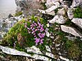
Purple Saxifrage at Sgùrr Ban.
See also
 In Spanish: Beinn Eighe para niños
