Eorodale facts for kids
Quick facts for kids Eorodale
|
|
|---|---|
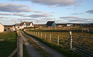
 Houses adjoining a lane at Eorodale |
|
| Language | Scottish Gaelic English |
| OS grid reference | NB536623 |
| Civil parish | |
| Council area | |
| Lieutenancy area | |
| Country | Scotland |
| Sovereign state | United Kingdom |
| Post town | ISLE OF LEWIS |
| Postcode district | HS2 |
| Dialling code | 01851 |
| Police | Northern |
| Fire | Highlands and Islands |
| Ambulance | Scottish |
| EU Parliament | Scotland |
| UK Parliament |
|
| Scottish Parliament |
|
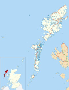
Eorodale (pronounced "YOR-uh-dal"), also known as Scottish Gaelic: Eòradal in Scottish Gaelic, is a small place where people live, called a settlement. It's found in the Outer Hebrides, a group of islands off the coast of Scotland. Eorodale is part of a larger area called Ness, which is on the northern tip of the Isle of Lewis.
Where is Eorodale?
Eorodale is located on the famous Isle of Lewis, which is the largest island in the Outer Hebrides. These islands are known for their stunning landscapes and unique culture.
Getting Around Eorodale
The settlement of Eorodale is situated along a road known as the B8015. This road connects Eorodale to other nearby places like Lionel and Skigersta. It's a key route for getting around this part of the island.
Eorodale's Local Area
Eorodale is also part of a traditional area called the parish of Barvas. Parishes are old divisions of land, often linked to churches, that help define local communities.
 | Tommie Smith |
 | Simone Manuel |
 | Shani Davis |
 | Simone Biles |
 | Alice Coachman |


