Loch Ewe facts for kids
Quick facts for kids Loch Ewe |
|
|---|---|

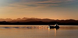
A Creel Boat on Loch Ewe at dawn
|
|
| Location | Northwest Highlands, Scotland |
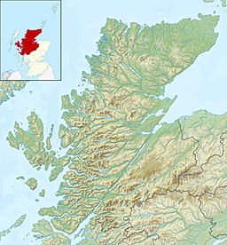
| Coordinates | 57°50′13″N 5°36′44″W / 57.83694°N 5.61222°W |
| Primary inflows | River Ewe |
| Primary outflows | The Minch |
| Basin countries | United Kingdom |
| Average depth | 15 m (49 ft) |
| Max. depth | 40 m (130 ft) |
| Islands | Isle of Ewe |
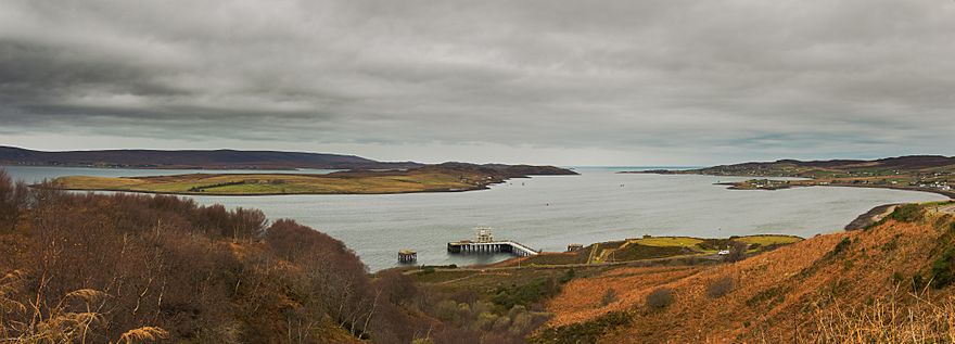
Loch Ewe (Scottish Gaelic: Loch Iùbh) is a sea loch located in the Northwest Highlands of Scotland. A sea loch is like a long, narrow arm of the sea that reaches inland. The people living around Loch Ewe traditionally speak Gàidhlig. Many live in small farming villages called crofting villages. The largest village is Aultbea, found on the north-eastern shore.
The River Ewe flows into Loch Ewe. This river is about four miles long. It collects water from thirteen smaller lochs in the surrounding areas. These include:
- Loch Maree
- Loch Fada
- Loch Garbhaig
- Loch Coulin
- Loch Clair
- Loch Tollaidh
- Loch Kernsary
- Loch Ghiuragarstidh
- Loch Mhic' Ille Rhiabhaich
- Loch a' Bhaid-Luachraich
- Loch Sguod
- Loch an t-Slagain
- Loch Drainc
Contents
Loch Ewe's Past: A Hub for Trade and Defense
Loch Ewe has always been an important place for ships and trade. This is because the land around it is very rough and hard to travel through.
Early Industry and Village Life
Around the year 1610, a town grew up at the top of Loch Ewe. This area is now called Poolewe. An iron furnace was built there. It used charcoal made from the local forests as fuel. English ironmakers found it cheaper to bring iron ore to Poolewe to melt it. This was easier than shipping the charcoal all the way to England.
In the 1840s, the local land was reorganized. This led to the creation of small crofting villages. These villages were always quite small. For example, in 1841, Bualnaluib had only eleven houses and fifty people. Mellon Charles had forty-one houses and two hundred and sixteen people. Ormiscaig had ten houses and forty-eight people. By 1981, the populations in these villages had become even smaller.
In 1911, a 70-foot lighthouse was built. It stands on the land between Gairloch and Poolewe.
Loch Ewe in World War II
Loch Ewe played a key role during the Second World War. It was a temporary home for the Home Fleet, which was the main part of the British Royal Navy.
The loch was also a meeting point for the Arctic Convoys. These were groups of ships that carried supplies to Murmansk in the Soviet Union. After a big disaster for Convoy PQ 17 in September 1942, ships started gathering at Loch Ewe. This helped to confuse German spies about their true destination.
When Germany surrendered in April 1945, many German U-boats (submarines) that had given up at sea came to Loch Ewe. It became the British gathering point for them.
During the war, the Royal Navy set up defenses around an inlet called Tournaig. This area was also known for its fish, like cod, haddock, and mackerel.
A local resident shared memories of the time. Their farmhouse was used as a barracks for anti-aircraft gunners. These gunners operated guns that shot down enemy planes. Concrete foundations and bomb shelters from that time can still be seen today. There was also a huge shed by the shore for barrage balloons. These balloons floated in the sky to protect against air attacks.
A small concrete jetty was built on the shore. The navy also put in a special mooring buoy for lobster boats.
There was a freshwater loch nearby called Loch nan Dalthein. It had small trout and sometimes sea-trout. A river flowed from this loch to the sea. It had a "salmon ladder," which is like a staircase of small pools. This allowed fish to jump up the river from Loch Tournaig to Loch nan Dalthein.
A small dam on the river helped create electricity for the farmhouse. It used a simple generator and provided 110 volts. The electricity was turned off at 10:00 PM each night.
Loch Ewe was a safe place for ships. It was protected from bad weather. It was also much further from Norway than the main naval base at Scapa Flow. This made it harder for German bombers to reach. Some say Loch Ewe was big enough to hold the entire Royal Navy. It was certainly important for ships protecting convoys in the Atlantic and possibly for the Russian convoys too.
The naval presence also led to a big improvement in local transport. A road was built from the railway station at Achnasheen, about forty miles away. Before this, there was no proper road. This new road helped the local economy. Fish could now be sent to markets in the south.
As of 2006, the Mellon Charles base is still active. It has two special berths, called "Z-berths," for nuclear-powered submarines. These berths allow NATO submarines to come in for maintenance without needing special warning. Another Z-berth is located in the middle of Loch Ewe itself. It is marked by a buoy but does not appear on regular maps.
The Naval Boom Defence depot at Mellon Charles shows where a protective net once guarded the loch's entrance. Part of the base is a Petroleum, Oil and Lubricants (POL) depot. This means it stores fuel and supplies for visiting warships.
Culture and Local Stories
Loch Ewe is famous for its beautiful scenery. Many people enjoy the views from the "midnight walk." This is a single-track road (the A832) north of Tournaig. The beauty of Loch Ewe is celebrated in many traditional Scottish songs called strathspeys. These songs are still sung at local gatherings called ceilidh. There are also great spots for taking photos along the Aultbea foreshore.
Old Stories and Storytellers
Sir George Douglas wrote about old folk and faerie stories from the Scottish mainland. He noted that these tales and myths were still told in places like the remote western islands of Barra. People would gather on long winter nights to listen to good storytellers.
This tradition also existed in Poolewe, Ross-shire, even in the mid-20th century. Young people would meet at night to hear elders tell stories they learned from their ancestors. Sometimes, traveling pedlars, musicians, or even shoemakers and tailors would tell stories. These traveling workers were nicknamed 'Whip-the-Cat'. They would stay at farmhouses and entertain everyone with tales while they worked.
When a storyteller arrived in a village, it was a big event. People would rush to the house where they were staying. Every seat would be taken. For hours, the storyteller would captivate the audience, like a great actor. The storytellers and listeners would feel strong emotions. They might be on the verge of tears one moment and burst into laughter the next. Many listeners truly believed the amazing things told in the stories.
These traditional storytelling scenes have had a big impact on Scottish literature.
Local Dialect
The English spoken in Red Point (near Gairloch) and Poolewe has a special sound. It is similar to the dialects spoken in the Southern Hebridean islands like Harris and Barra. This dialect has a unique way of saying certain sounds, especially a long 'h' sound.
 | Dorothy Vaughan |
 | Charles Henry Turner |
 | Hildrus Poindexter |
 | Henry Cecil McBay |


