Isle of Ewe facts for kids
| Gaelic name | Eilean Iùbh |
|---|---|
| Meaning of name | Yew |
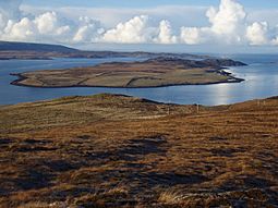
 Looking north west over the Isle of Ewe |
|
| OS grid reference | NG855885 |
| Coordinates | 57°50′N 5°37′W / 57.83°N 5.61°W |
| Physical geography | |
| Island group | Loch Ewe |
| Area | 309 ha (760 acres) |
| Area rank | 87= |
| Highest elevation | Creag Streap 72 m (236 ft) |
| Administration | |
| Sovereign state | United Kingdom |
| Country | Scotland |
| Council area | Highland |
| Demographics | |
| Population | 7 |
| Population density | 2.2/km2 (5.7/sq mi) |
The Isle of Ewe (Scottish Gaelic: Eilean Iùbh) is a small Scottish island. It is located on the west coast of Ross and Cromarty. Only one family, the Grants, lives on the island. They have lived at the Main House in the south of the island since the mid-1800s.
A person named J.I.H. Macdonald-Buchanan owns the island. The Grants rent it from them. More families used to live here. But they left during World War II. At that time, Loch Ewe was an important place for navy ships. Because the island is so isolated, children had to travel far for school. They took a daily trip of about 26 miles (42 kilometres) by boat and bus.
Contents
What's in a Name? The Isle of Ewe
There are two main ideas about where the island's name comes from. One idea is that it comes from an old Irish word, eo. This word means "yew tree".
The other idea is that the name comes from the Gaelic word eubh. This word means "echo". This might refer to a place on the nearby mainland that also has an echo.
Island Landscape: Geography and Geology
The Isle of Ewe is found in Loch Ewe. It is west of Aultbea in the Ross and Cromarty area. This area is part of the Highland Region. The island is made of two main types of sandstone. In the north, there is Torridonian sandstone with acidic soil. In the south, there is Permian or Triassic sandstone with more fertile soil.
The coastline of the island changes a lot. You can find flat pebble beaches and tall cliffs. The Isle of Ewe is part of the Wester Ross National Scenic Area. This is one of 40 such special areas in Scotland.
A Look Back: How the Island Changed
The Isle of Ewe used to be covered in trees. In 1549, a priest named Donald Monro wrote about it. He said the island was "full of woods". He also mentioned it was "good for thieves to wait upon uther mens gaire". This means it was a good hiding spot for people who stole things.
Another writer, George Buchanan, wrote about the island in 1579. He said it was "almost all covered with woods". He also thought it was "good for nothing but to harbour thieves". Both Monro and Buchanan made a mistake. They thought the island was in Loch Broom, not Loch Ewe.
By 1889, the island had changed a lot. A travel guide called Black's Picturesque Tourist of Scotland described it. It said the Isle of Ewe was "in a state of high cultivation". This means it had many farms. The fields were large and well-fenced. They had been made from moorland. The island also had a large dairy farm.
Today, the southern part of the island is mostly low-lying farmland. But the northern part is still wild and not farmed.
Special Spots on the Island
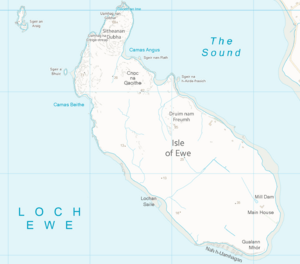
The highest part of the Isle of Ewe is in the north. It rises to 72 metres (236 feet) at a spot called Creag Streap. This name means "climbing cliff". Just offshore, there is a noticeable rock called Sgeir a' Bhuich. This means "rock of the roe-buck". Further out in the loch, to the north-west, is a larger rocky island named Sgeir an Araig.
A peaty, hilly area covers most of the northern part of the island. It is called Sitheanan Dubha, which means "the black fairy hillocks". This area reaches a height of 68 metres (223 feet). It is covered with coarse grass, heather, and sphagnum moss. In the 1880s, some boys said they saw fairies in this spot.
Just south of this area are two bays. They are called Camas Angus ("Angus' bay") and Camas Beithe ("birch-tree bay"). These bays are good places for boats to anchor. A small hill called Cnoc na Gaoithe ("windy knoll") protects these two bays.
The farmed land starts a short distance further south. It is beyond an area called Druium nam Freumh ("ridge of roots"). Here, you can find a small area of woodland. A jetty was built after the Second World War. It helps people get to the mainland by boat.
The island does not have regular boat services. But you can arrange to visit from Aultbea.
 | Precious Adams |
 | Lauren Anderson |
 | Janet Collins |


