Ross, Scotland facts for kids

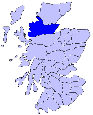
Ross (pronounced like "raws") is a special area in Scotland. It was one of the main parts of Scotland way back in the 800s. This region gave its name to an old noble title called the earldom and later to areas known as Ross-shire and Ross and Cromarty.
The name Ross might come from a Scottish Gaelic word meaning "headland," which could be about the Black Isle area. Another idea is that it comes from an old Norse word, Hrossey, meaning "horse island." This makes sense because the area was once part of the Norwegian earldom of Orkney. Ross is also a region used by the Kirk, with its own group of churches called the Presbytery of Ross.
History of Ross
Long, long ago, people lived along the coast of Wester Ross. Scientists found tools and shells at a place called Sand, Applecross, showing that hunter-gatherers lived there during the Mesolithic period (Middle Stone Age).
Around 200 AD, a Roman writer named Ptolemy wrote about a tribe called the Decantae living in what is now Easter Ross. The Romans probably didn't settle here. For a long time, the land was home to the Picts, who became Christians in the 500s and 600s, thanks to followers of Saint Columba.
For the next 300 years, Viking raiders from Norway often attacked the people of Ross. You can still see signs of them in place names like Dingwall and Tain. At that time, Ross was part of a much larger area called Moray.
Ross was first mentioned as a specific place in a story about Saint Cathróe of Metz, written around 971-976 AD.
Later, important events happened in Ross. William, the 4th Earl of Ross, and his clan fought at the Battle of Bannockburn in 1314. Almost 100 years later, in 1412, Donald, Lord of the Isles, captured Dingwall Castle, a main stronghold. He fought the Battle of Harlaw because he believed his wife, Mariota, had a rightful claim to the earldom of Ross. After the battle, the people of Ross supported Donald and Mariota.
In 1476, the earldom of Ross became part of the crown again because of John Macdonald, the last Lord of the Isles and Earl of Ross. Five years later, King James III gave it to his second son, James Stewart.
By the 1500s, different clans lived in different parts of Ross. The Rosses lived in Easter Ross, the Munros near Ben Wyvis, the Macleods in Lewis and parts of the mainland, the Macdonalds in Coigach, and the Mackenzies in the rest of the area.
The county of Ross was officially formed in 1661. Later, it joined with Cromarty in 1889 to become the county we know today.
There were a few battles in Ross. In 1650, Montrose was defeated at Invercarron. In 1719, the Jacobites, led by the Earl of Seaforth and helped by Spaniards, were defeated at Battle of Glenshiel.
Geography of Ross
Ross is located in the north of Scotland. To its north is Sutherland and the Dornoch Firth. To the west is The Minch, and to the east are the North Sea and the Moray Firth. To the south are the Beauly Firth and Inverness-shire.
There are also some small islands off the west coast, including:
- Gillean (which has a lighthouse)
- Crowlin Islands
- Eilean Horrisdale
- Isle of Ewe
- Isle Martin and Tanera More (part of the Summer Isles)
The mainland part of Ross covers a huge area of about 1,572,332 acres (636,300 hectares).
On the eastern side, facing the North Sea, you'll find large inlets of the sea called firths. These include the Beauly Firth and the Moray Firth, which separate the Black Isle from Inverness-shire. The Cromarty Firth borders Easter Ross and the Black Isle. The Dornoch Firth separates north-east Ross from Sutherland.
On the western side, facing the Atlantic Ocean, the coastline is very long, about 311 miles (500 km). Here you'll find many sea lochs (long, narrow inlets of the sea) and bays. From south to north, some of the main ones are Loch Duich, Loch Alsh, Loch Carron, Loch Kishorn, Loch Torridon, Loch Shieldaig, Upper Loch Torridon, Gair Loch, Loch Ewe, Gruinard Bay, Loch Broom and Enard Bay.
The main points of land sticking out into the sea (capes) include Tarbat Ness on the east coast, and Coigach, Greenstone Point, Rubha Reidh, Redpoint and Hamha Point on the west.
Most of the southern border with Inverness-shire is made up of tall mountains, many of which are Munros (mountains in Scotland over 3,000 feet or 914.4 meters high). Some of these are:
- An Riabhachan (3,704 feet)
- Sgurr na Lapaich (3,773 feet)
- Carn Eige (3,881 feet)
- Mam Sodhail (3,871 feet)
- Beinn Fhada (3,386 feet)
- Sgurr Fhuaran (3,504 feet)
- The Saddle (3,317 feet)
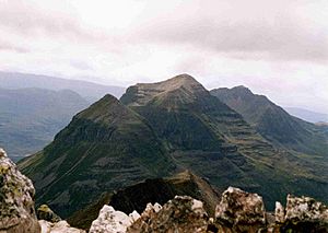
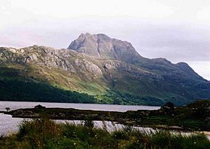
North of Glen Torridon are other large mountains like Liathach (3,455 feet), Beinn Eighe (3,313 feet), Beinn Alligin (3,235 feet) and Beinn Dearg (2,998 feet). On the shore of Loch Maree is Slioch (3,219 feet). The Fannich group has six Munros, with Sgurr Mor (3,645 feet) being the highest. The huge, stand-alone mountain of Ben Wyvis (3,428 feet) is a famous sight in the north-east. An Teallach (3,484 feet) in the north-west is also very noticeable. Only a small part of the west and south of Ross is lower than 1,000 feet. Easter Ross and the Black Isle are flatter areas.
The longest river in Ross is the River Orrin, which flows north-east for about 26 miles (42 km) until it joins the River Conon. At Aultgowrie, the river drops a lot, creating the Falls of Orrin. The River Blackwater flows southeast for 18 miles (29 km) to join the Conon, forming the pretty Falls of Rogie. The Conon River itself has many waterfalls and fast-flowing sections before it reaches the Cromarty Firth. In the southwest, you can find the amazing Falls of Glomach, where a stream drops 110 meters (360 feet) in one sheet of water. Near Ullapool, the Falls of Measach are formed by the Droma River, with three cascades near Corrieshalloch Gorge. The River Oykel forms the border with Sutherland.
Ross has many freshwater lochs (lakes). The biggest is Loch Maree. In the far north-west, Loch Sionascaig is very twisty, with a shoreline of 17 miles (27 km). It has several wooded islands and flows into Enard Bay. Lochan Fada (the long loch) is 4 miles (6 km) long and very deep. Other important lochs include Fionn Loch (known for its herons), Loch Luichart (shaped like a crescent), Loch Fannich, and the wild, narrow Lochs Monar and Mullardoch on the border with Inverness-shire.
The more important straths (valleys) in Ross run from the center towards the east, such as Strathconon, Strathbran, Strathgarve, Strathpeffer, and Strathcarron. In the south and west, you'll find longer glens (narrow valleys). In the far south, Glen Shiel runs between five mountains (the Five Sisters of Kintail) to Loch Duich. The A87 road goes through this glen. Further north are Glen Elchaig, Glen Carron, and Glen Torridon. A railway line from Dingwall goes through Glen Carron to Kyle of Lochalsh.
Climate and Farming
The west coast of Ross gets a lot of rain, with an average of about 50 to 62 inches (1,280 to 1,570 mm) per year, especially in autumn and winter. But on the east coast, it's much drier, with only about 27 inches (686 mm) of rain each year. The average daily high temperature for the year is around 46.5°F (8.1°C). In January, the average high is about 38°F (3°C), and in July, it's about 57°F (14°C).
The best farming land is on the eastern coast, especially in Easter Ross and the Black Isle. The soil there can be sandy or rich and deep. In the past, oats were the most common grain grown, but barley and wheat were also farmed. Turnips and potatoes were important "green crops."
Higher up, there's good grassland for animals. Many sheep are raised, especially the blackfaced breed. Horses, often a mix of strong local ponies (garrons) and Clydesdales, were used for farm work. There were also large herds of cattle, mostly native Highland cows or mixed breeds, many of which were sent to markets in London. Pigs were also raised, especially by crofters (people who farm small plots of land).
A long time ago, a huge area of Ross, about 800,000 acres (320,000 hectares), was used for deer forests (areas managed for deer hunting). This was more than any other county in Scotland. Some of the largest were Achnashellach (50,000 acres), Fannich (20,000 acres), and Braemore (40,000 acres). The name "Ross" might even come from an old Irish word for "wood," suggesting there were many trees here in the past. There were still large areas of native woodlands, mainly pine, oak, ash, and alder trees.
The animals in Ross were interesting. Red and roe deer were common, as were foxes and alpine hares. Sometimes, badgers and wild cats were seen. There were many types of game birds, and birds of prey like the golden eagle and osprey could be found. All kinds of waterfowl lived in the sea lochs. Many rivers and lochs were full of salmon and trout. Even pearl mussels were found in the Conon River.
Other Industries
Today, tourism is a very important industry in Ross. More than 20% of the people working in the area are in jobs related to hotels, restaurants, and shops. This is second only to public services. About 5% of workers are in farming, forestry, and fishing, which used to be the main jobs here. The oil industry, which grew a lot in the 1970s, is not as big as it used to be, but it still provides many jobs.
The Glen Ord and Glenmorangie distilleries are famous places that make whisky.
A railway line, the Far North Line, comes into Ross from Inverness. It goes north through Dingwall and then to Tain, along the south side of the Dornoch Firth. From there, the train line continues north to Thurso and Wick in Caithness. Another line, the Kyle of Lochalsh Line, goes west from Dingwall to the Kyle of Lochalsh.
Ancient Sites
The main ancient sites in Ross are found in the eastern part of the area. These include stone circles, cairns (piles of stones), and forts.
One interesting site is a vitrified fort (a fort where the stones were heated so much they melted together) on Knockfarrel hill. There's also a round dun (a type of fort) near Lochcarron village.
Some beautiful carved stones have been found. Three of these stones are said to mark the burial place of three sons of a Danish king who were shipwrecked. The biggest and most beautiful of these crosses, called the Clach a' Charraidh (Stone of Lamentation), stands at Shandwick. It's about 10 feet (3 meters) tall and shows pictures of Saint Andrew being martyred, along with an elephant and a dog. It fell in a storm in 1847 and broke into three pieces, but it has been put back together. Another cross in Nigg churchyard shows two figures praying, with a dove and two dogs. This cross was also damaged but has been repaired. A third stone, which used to be at Hilton of Cadboll, was moved to Invergordon Castle for safety.
There are also old castles, such as Lochslin Castle in Fearn, which might be from the 1200s. Even though it's in ruins, it still has two square towers. Balone Castle in Tarbat was once a strong base for the Earls of Ross. The remains of Dingwall Castle were their first main home. And Eilean Donan Castle in Loch Alsh was blown up by British warships during the Jacobite rising in 1719.
 | Selma Burke |
 | Pauline Powell Burns |
 | Frederick J. Brown |
 | Robert Blackburn |


