Mam Sodhail facts for kids
Quick facts for kids Mam Sodhail |
|
|---|---|

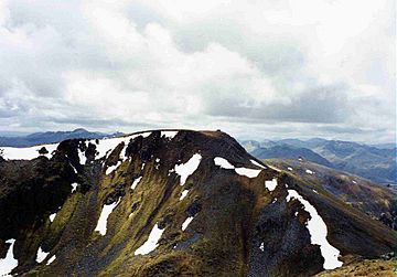
Mam Sodhail seen from Càrn Eige, 1 km to the NE.
|
|
| Highest point | |
| Elevation | 1,181 m (3,875 ft) |
| Prominence | c. 137 m |
| Listing | Munro |
| Naming | |
| English translation | Hill of the Barns |
| Language of name | Gaelic |
| Geography | |
| Location | Glen Affric, Scotland |
| Parent range | Northwest Highlands |
| OS grid | NH119253 |
| Topo map | OS Landranger 25, OS Explorer 414 |
Mam Sodhail, also called "Mam Soul", is a famous mountain in Scotland. It is located in a quiet area north of Glen Affric. This spot is about 30 kilometers east of Kyle of Lochalsh.
Mam Sodhail is known as a Munro. A Munro is a Scottish mountain that is over 3,000 feet (914.4 meters) tall. Climbing Munros is a popular hobby in Scotland.
Contents
About Mam Sodhail Mountain
Mam Sodhail stands at 1,181 meters (3,875 feet) high. This makes it the second tallest mountain north of the Great Glen. The Great Glen is a long, narrow valley that cuts across Scotland.
Its neighbor, Càrn Eige, is just one kilometer north. These two mountains are like twins because they are almost the same height and look very similar. They rise above a valley called Gleann nam Fiadh, which means "Glen of the Deer".
A high ridge connects Mam Sodhail and Càrn Eige. This makes it easy for hikers to climb both mountains in one day. The name "Mam Sodhail" comes from the Gaelic words meaning "Hill of the Barns".
Mountain Features and Summit
Mam Sodhail is mostly covered in grass, with not too many rocky parts. But its huge size, long ridges, and beautiful corries make it a fantastic mountain. A corrie is a bowl-shaped hollow on the side of a mountain.
The mountain has four smaller peaks, or "tops," listed in the Munro Tables. These tops add to the mountain's impressive look.
Main Ridges and Peaks
Mam Sodhail has three main ridges that stretch down towards Glen Affric. The most striking one is the east-southeast ridge. This ridge has two important "tops" on it.
- Mullach Cadha Rainich is 996 meters high. It sits in the middle of this ridge.
- Sgurr na Lapaich is 1,036 meters high. It is at the end of the ridge, about four kilometers away.
Sgurr na Lapaich is the most noticeable part of Mam Sodhail when you look from Glen Affric. It looks like its own separate mountain. In fact, it was once considered a Munro itself in the first list from 1891.
The other two ridges form a horseshoe shape around the Allt Coulavie valley. This valley is located south of the main summit. These ridges include two more "tops":
- An Tudair is 1,074 meters high.
- Creag Coire nan Each is 1,055 meters high.
The western sides of Mam Sodhail slope down towards Gleann a’ Choilich. This valley drains water north into Loch Mullardoch.
The Summit Cairn and Bothy
Mam Sodhail was very important for the Ordnance Survey in the 1840s. The Ordnance Survey is a mapping agency that creates detailed maps of Great Britain. Surveyors used Mam Sodhail to help map the northern Highlands.
At the very top of the mountain, there is a huge cairn. A cairn is a pile of stones built as a landmark. This cairn was used by the surveyors for their work. It is hollow inside, and you have to climb its walls to get in. What's cool is that there's even a visitors' book inside the cairn!
Just below the summit, you can find the remains of a small bothy. A bothy is a basic shelter, like a small hut. This one still has its walls, a fireplace, and a chimney. Long ago, deerstalkers and watchers used it. They stayed there to keep sheep and walkers away from the mountain.
Sir Hugh Munro, who created the list of Munros, even mentioned this bothy. He wrote about it in the Scottish Mountaineering Club Journal. He also gave tips on how to get around it and its users.
There is also evidence of some quarrying southwest of the main summit. This is on the ridge leading to Creag Coire nan Each. You can see several pits, about three meters deep. It is likely that these pits were where the stone for the summit cairn and the bothy came from.
How to Climb Mam Sodhail
Most people start their climb of Mam Sodhail from the car park in Glen Affric. You can find it at grid reference NH200233.
There are a couple of ways to hike up the mountain:
- You can follow a special path called a "stalker's path" up Coire Leachavie. A stalker's path is a track used by people who manage deer on the land.
- Another way is to climb Sgurr na Lapaich first. Then, you follow the long east-southeast ridge all the way to the top of Mam Sodhail.
From the summit, you get amazing views. You can see the impressive Sgùrr nan Ceathramhnan and Càrn Eige very close by. In the distance, you can see many other mountains of the north-west Highlands.
Most hikers will also climb Càrn Eige, which is nearby, as part of their trip. Stronger hikers might even try to climb Beinn Fhionnlaidh. This Munro is about three kilometers north and is hard to reach from other places.
 | Percy Lavon Julian |
 | Katherine Johnson |
 | George Washington Carver |
 | Annie Easley |


