An Riabhachan facts for kids
Quick facts for kids An Riabhachan |
|
|---|---|

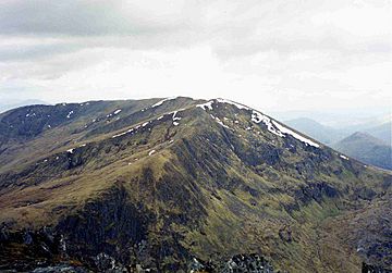
An Riabhachan seen from Sgurr na Lapaich, three kilometres to the east.
|
|
| Highest point | |
| Elevation | 1,129 m (3,704 ft) |
| Prominence | 302 m (991 ft) |
| Listing | Munro, Marilyn |
| Naming | |
| English translation | The Brindled One |
| Language of name | Gaelic |
| Pronunciation | English approximation: ƏN-reer-VƏ-khan |
| Geography | |
|
Lua error in Module:Location_map at line 420: attempt to index field 'wikibase' (a nil value).
|
|
| Parent range | Northwest Highlands |
| OS grid | NH133344 |
| Topo map | OS Landranger 25, OS Explorer 414 |
| Listed summits of An Riabhachan | ||||
| Name | Grid ref | Height | Status | |
|---|---|---|---|---|
| South West Top | NH122336 | 1086 m (3563 ft) | Munro Top | |
| West Top | NH117337 | 1040 m (3412 ft) | Munro Top | |
An Riabhachan is a tall mountain in the Highland area of Scotland. It stands alone, about 35 kilometers (22 miles) east of Kyle of Lochalsh. You won't find any public roads close by, as it's quite remote, about ten kilometers (6 miles) from the nearest one. It's located at the western end of Loch Mullardoch.
Contents
What is An Riabhachan?
An Riabhachan is very tall, reaching 1,129 meters (3,704 feet) high. It's one of the highest Munros (Scottish mountains over 3,000 feet) found north of the Great Glen. Its name comes from the Gaelic language. It means 'The Brindled One,' which probably describes the mountain's look. Imagine it having a flecked or spotted pattern from the rocks and grass.
Exploring An Riabhachan's Geography
An Riabhachan is mostly covered in grass. The only rocky part is at the north-east end of its top ridge. This area is above a cool, rocky hollow called Coire Gnada. Inside Coire Gnada, you'll find two small lakes, Loch Mòr and Loch Beag.
The mountain has a long ridge at its top, stretching about 2.5 kilometers (1.5 miles). This ridge stays high, never dropping below 1,000 meters (3,280 feet). It also has a few other high points along its length.
Key High Points of An Riabhachan
- The North East Top is 1,125 meters (3,691 feet) high. For a while, it was thought to be the main summit of the mountain. However, the current summit was later confirmed as the highest point.
- The West Top is 1,040 meters (3,412 feet) high. It's at the far western end of the main ridge. From here, the land drops down to a mountain pass called Bealach Bholla. Then it rises again to another Munro, An Socach.
- The South West Top is 1,086 meters (3,563 feet) high. It's located about 700 meters (2,300 feet) south-east of the West Top.
The grassy slopes of the summit ridge gently fall away on both sides. To the south, they lead down to Loch Mullardoch. To the north, they go towards the upper part of Glen Strathfarrar.
How to Climb An Riabhachan
People often climb An Riabhachan along with two or three other Munros. These other mountains are also located on the north side of Loch Mullardoch.
Starting from Mullardoch Dam
The most common way to climb these four Munros starts at the Mullardoch dam. This dam is in Glen Cannich (at grid reference NH219316). From there, you walk about 9 kilometers (5.6 miles) along the northern shore of the loch. Then, you climb An Socach, continue to An Riabhachan, and return by climbing Sgurr na Lapaich and Càrn nan Gobhar. You can even hire a boat to skip the long walk along the loch shore. This boat service is usually available between April 1st and August 1st. It's a good idea to include An Socach in your climb if you can, as it's a remote Munro that's hard to reach otherwise.
Starting from Glen Strathfarrar
Another way to climb An Riabhachan is from Glen Strathfarrar to the north. You start at the hydroelectric power station in Gleann Innis (at grid reference NH182381). To get there, you drive 17 miles from Struy on a private road. The gate to this road is usually locked but opens at specific times for vehicles. From the power station, a path used by deer stalkers leads to the mountain pass called Bealach Toll an Lochain. This pass is between An Riabhachan and Sgurr na Lapaich. From there, you climb over 300 meters (984 feet) west to reach the summit of An Riabhachan. You can return to the power station by going over Sgurr na Lapaich and Càrn nan Gobhar.
 | Tommie Smith |
 | Simone Manuel |
 | Shani Davis |
 | Simone Biles |
 | Alice Coachman |

