Càrn nan Gobhar (Mullardoch) facts for kids
Quick facts for kids Càrn nan Gobhar |
|
|---|---|

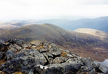
Càrn nan Gobhar seen from Sgurr na Lapaich, 2.5 km to the NW.
|
|
| Highest point | |
| Elevation | 992 m (3,255 ft) |
| Prominence | 198 m (650 ft) |
| Listing | Munro, Marilyn |
| Naming | |
| English translation | Cairn of the Goat |
| Language of name | Gaelic |
| Pronunciation | English approximation: KARN-nən-KOH-ər |
| Geography | |
| Location | Highland, Scotland |
| Parent range | Northwest Highlands |
| OS grid | NH181343 |
| Topo map | OS Landranger 25, OS Explorer 430 |
| Listed summits of Càrn nan Gobhar (Mullardoch) | ||||
| Name | Grid ref | Height | Status | |
|---|---|---|---|---|
| Creag Dubh | NH199350 | 947 m (3107 ft) | Munro Top | |
Càrn nan Gobhar is a mountain in Scotland. It is located on the northern side of Loch Mullardoch. This area is in the upper part of Glen Cannich. The mountain is about 50 kilometres west-southwest of the city of Inverness.
Càrn nan Gobhar is part of a group of four Munros. These mountains are sometimes called “The Mullardochs”. They form the high ground between Loch Mullardoch and Loch Monar.
Contents
What is Càrn nan Gobhar?
Càrn nan Gobhar stands 993 metres (3258 feet) tall. This height makes it a Munro and a Marilyn. A Munro is a Scottish mountain over 3,000 feet (914.4 metres). A Marilyn is a hill with a prominence of at least 150 metres.
There is another mountain with the same name, Càrn nan Gobhar. It is also a Munro and has the exact same height. This other mountain is about 14 kilometres to the northeast, near Glen Strathfarrar.
The Mountain's Name
The name Càrn nan Gobhar comes from the Gaelic language. It means “Cairn of the Goats”. A cairn is a pile of stones, often used to mark a summit or path. In this case, it means "hill of the goats".
How Does the Mountain Look?
Càrn nan Gobhar is the lowest of the four Munros on the north side of Loch Mullardoch. It has a fairly simple shape. Most of it is covered in rolling grassy slopes. You will also see patches of rock and scree (loose stones). The western and eastern sides have steeper slopes.
Where is Càrn nan Gobhar Located?
Càrn nan Gobhar has three main ridges. These ridges give the mountain a rough triangle shape.
Main Ridges and Nearby Peaks
- Southeast Ridge: This ridge is about 3.5 kilometres long. It goes over a smaller peak called Mullach na Moille (761 metres). Then it turns east and drops down to the eastern end of Loch Mullardoch.
- Northwest Ridge: This ridge connects Càrn nan Gobhar to another Munro called Sgurr na Lapaich. They are linked by a mountain pass called the Bealach na Cloiche Duibhe. A "bealach" is a Gaelic word for a mountain pass or saddle between two peaks.
- Northeast Ridge: This ridge leads to a "Munro Top" called Creag Dubh. Creag Dubh is 947 metres tall. A "Munro Top" is a peak that is part of a Munro but not a Munro itself. Creag Dubh was first listed as a mountain in 1891 by Sir Hugh Munro. But in 1921, it was changed to a "Top". The northern slopes of Creag Dubh are rocky as they go down to the Glen Strathfarrar Forest.
Coire an t-Sith (Corrie of the Fairies)
One of the most interesting parts of Càrn nan Gobhar is its south-facing corrie. A corrie is a bowl-shaped hollow on a mountainside, often formed by glaciers. This one is called Coire an t-Sith, which means "Corrie of the Fairies".
A stream called the Allt Mullardoch flows from this corrie. It goes down to Loch Mullardoch in a series of small waterfalls. There is a well-built path in the corrie. Hikers can use this path to make a high-level loop around the corrie. This loop includes the Munro summit and the "Top" of Creag Dubh.
All the water from the mountain flows east. It eventually reaches the Beauly Firth through the glens of Strathfarrar or Cannich.
How to Climb Càrn nan Gobhar
The easiest way to start climbing Càrn nan Gobhar is from the parking area. This is at the end of the public road in Glen Cannich. It's near the Loch Mullardoch dam, at grid reference NH219315.
The Climbing Route
The path follows the northern shore of the loch for about 1.5 kilometres. Then, it climbs steeply up the southeast ridge. You will pass over Mullach na Moille on your way to the summit.
Experienced hikers often climb Càrn nan Gobhar along with Sgurr na Lapaich. Very strong walkers might also climb the other two Mullardoch Munros: An Riabhachan and An Socach.
The Summit Views
The top of Càrn nan Gobhar is a wide, flat ridge that runs north to south. There are two cairns (piles of stones) about 200 metres apart. The smaller northern cairn marks the true summit.
From the summit, you get great views to the north. You can see the Monar Forest Munros, like Maoile Lunndaidh and Lurg Mhòr. It's also a good spot to see the corries and cliffs of the nearby Sgurr na Lapaich.
 | Jewel Prestage |
 | Ella Baker |
 | Fannie Lou Hamer |


