
Sgùrr na Lapaich facts for kids
Quick facts for kids Sgurr na Lapaich |
|
|---|---|

Sgurr na Lapaich seen from Càrn nan Gobhar, 2 km to the south-east.
|
|
| Highest point | |
| Elevation | 1,150 m (3,770 ft) |
| Prominence | 839 m (2,753 ft) Ranked 24th in British Isles |
| Parent peak | Càrn Eige |
| Listing | Munro, Marilyn |
| Naming | |
| English translation | Peak of the Bog |
| Language of name | Gaelic |
| Pronunciation | English approximation: SKOOR-nə-LAP-ish |
| Geography | |
| Location | Glen Cannich, Scotland |
| Parent range | Northwest Highlands |
| OS grid | NH160351 |
| Topo map | OS Landranger 25, OS Explorer 430 |

Sgurr na Lapaich is a tall mountain in the Northwest Highlands of Scotland. It stands north of Loch Mullardoch, between two valleys called Glen Cannich and Glen Strathfarrar. This mountain reaches a height of 1,150 metres (3,773 feet). It is the fourth highest mountain north of the Great Glen in Great Britain. No other land is higher than it to its north in Great Britain.
Sgurr na Lapaich is a great place to see far-off views. It rises 839 metres from the land around it. This makes it a very noticeable landmark. You can see it clearly from the east, even from the Moray Firth, which is about 30 miles away. Local people sometimes use the mountain to help them guess the weather.
It is important not to confuse this mountain with another smaller peak also called Sgurr na Lapaich. That one is part of a mountain called Mam Sodhail.
Contents
What Does Sgurr na Lapaich Mean?
The name Sgurr na Lapaich comes from the Gaelic words for "Peak of the Bog." This name might sound a bit strange for such a grand mountain. Sgurr na Lapaich is a beautiful mountain with long, narrow ridges. It also has deep, bowl-shaped valleys called corries. You can find small lakes, known as lochans, on its slopes. The mountain ends in a rocky peak.
Mountain Features and Nearby Peaks
Sgurr na Lapaich is connected to other mountains by its ridges. To the west, it links to An Riabhachan. To the east, it connects to Càrn nan Gobhar. Both of these are also Munros, which are Scottish mountains over 3,000 feet (914.4 metres) high.
South of the main summit, Sgurr na Lapaich has a smaller peak. This peak is called Sgurr nan Clachan Geala and is 1,093 metres high. It is listed as a "top" in the official list of Munros. Another small peak, Rudha na Spreidhe, is on the mountain's northern side. It offers good views of Loch Monar. This peak used to be on the list of tops but has since been removed.
Valleys and Lakes Around the Mountain
Deep, ice-carved valleys, or corries, surround Sgurr na Lapaich. To the south-east of the summit, the land drops steeply into a large corrie. This corrie holds Loch Tuill Bhearnach, the biggest lochan on Sgurr na Lapaich. It is about 500 metres wide. Further south, there is a smaller corrie with Loch a' Choire Bhig. Both of these lochans flow into Loch Mullardoch.
To the east of the summit, you will find the steep, rocky wall of Coire nan Each. This corrie often stays filled with snow until late spring.
How to Climb Sgurr na Lapaich
You can climb Sgurr na Lapaich from two main areas: Glen Strathfarrar or Glen Cannich.
Climbing from Glen Cannich
The most common way to climb from Glen Cannich starts at the parking area. This spot is near the Loch Mullardoch dam (grid reference NH219315). The climb usually begins by going up the Munro called Càrn nan Gobhar. You follow its south ridge. After that, the path goes north-west to a dip in the land, called a col, at 796 metres. From there, you climb the wide, grassy east ridge of Sgurr na Lapaich. Higher up, the ridge becomes rocky. You might need to do some easy climbing over rocks to reach the very top.
Climbing from Glen Strathfarrar
To climb from Glen Strathfarrar, you start from the hydroelectric power station in Gleann Innis (grid reference NH182381). To get there, you drive 17 miles from Struy on a private road. The gate to this road is usually locked. It opens at certain times to let cars through. However, people walking or cycling can go through the gate at any time. From the power station, a path used by deer stalkers leads to the col between An Riabhachan and Sgurr na Lapaich. From this point, you still have to climb over 300 metres to reach the summit.
The very top of Sgurr na Lapaich has a special marker. It is an Ordnance Survey trig point, which helps mapmakers.
Images for kids
-
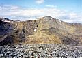
Sgurr na Lapaich seen from Càrn nan Gobhar, 2 km to the south-east.
-
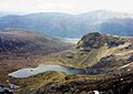
Looking south-east from the summit over Loch Tuill Bhearnach with Loch Mullardoch in the far valley.
