
Glen Strathfarrar facts for kids
Quick facts for kids Glen Strathfarrar National Scenic Area |
|
|---|---|

View along the glen across Loch Beannacharan, with Sgùrr na Lapaich beyond
|
|

Glen Strathfarrar National Scenic Area
Location in Highland
|
|
| Location | Highland, Scotland |
| Area | 40 km2 (15 sq mi) |
| Established | 1981 |
| Governing body | NatureScot |
Glen Strathfarrar (which means Srath Farair in Gaelic) is a beautiful valley in the Highland area of Scotland. It is located not far from the famous Loch Ness.
This glen is an important part of the Affric-Beauly hydro-electric power scheme. This project uses water to create electricity. There is a large dam at Loch Monar. A long tunnel carries water from there to an underground power station called Deanie. Another dam near Loch Beannacharan sends water to Culligran power station. The dam at Loch Monar is the biggest arch dam in Britain.
A big part of Glen Strathfarrar is a National Scenic Area. This means it is a special place with amazing views. These areas are protected to keep their natural beauty safe. The part of the glen that is a National Scenic Area includes the lovely Culligran Falls.
Contents
What's in a Name? The Meaning of Strathfarrar
Glen Strathfarrar gets its name from the River Farrar. This river was known as Varrar in Roman times. The name might come from an old word meaning "to wind" or "bending river." It could also mean "gentle river."
The full name "Glen Strathfarrar" is a bit unusual. A "strath" is already a long, wide valley, similar to a "glen." So, saying "Glen Strath" is like saying "Valley Valley." It probably happened because someone writing maps didn't know what "Strath" meant. They just added "Glen" in front of "Strathfarrar."
Exploring the Geography of Glen Strathfarrar
The River Farrar (or Farar / Uisge Farair in Gaelic) starts when two smaller rivers meet. These are the Uisge Misgeach and the Garbh-uisge. This happens about 2 km after the Garbh-uisge leaves Loch Monar.
The river then winds its way along the flat valley floor. It flows east through two lochs: Loch a' Mhuillidh and Loch Beannacharan. Loch Beannacharan has a dam as part of the hydro-electric power scheme. The river continues east, flowing over the beautiful Culligran Falls. Finally, it joins the River Glass to form the River Beauly. This happens near the village of Struy.
There are many mountains around the glen. Many people enjoy hiking them. Some of these tall mountains are called Munros. These include Sgùrr a' Choire Ghlais and Sgurr Fhuar-thuill to the north. To the south, you can find Sgùrr na Lapaich and An Riabhachan. There are also two smaller mountains called Corbetts. These are Beinn a' Bha'ach Ard and Sgorr na Dìollaid.
Amazing Nature and Wildlife

Glen Strathfarrar is home to parts of the Caledonian Forest. This is an ancient forest made mostly of Scots pine trees. These trees grew here after the last Ice Age, thousands of years ago. This forest is a very important home for many animals. These include the capercaillie, a large bird, and the crested tit. You might also see the Scottish crossbill, a bird found only in Scotland.
Over the years, logging and people settling in the area have changed the forest. Besides pine trees, there are also areas of birch trees. You can also find open areas with heather, bracken, and grass.
Many animals live in Glen Strathfarrar. You might spot Red deer, otters, and even golden eagles flying overhead. The glen is also home to several types of dragonfly.
Glen Strathfarrar is a very important natural area. It is protected under special programs like Natura 2000. It is also a Site of Special Scientific Interest (SSSI). This means its wildlife and habitats are carefully looked after. In the past, people suggested making it a national park. However, this has not happened yet.
A Glimpse into History
A small island in Loch a' Mhuillidh holds old ruins. These are the remains of a building used by Simon Fraser, 11th Lord Lovat. He hid there after the Battle of Culloden in 1746. This battle was part of the Jacobite rising of 1745.
After this rebellion, big changes happened in the Highlands. People started raising sheep and creating deer forests. This led to many people moving away from the area in the 1800s. This time is known as the Highland clearances. The building of the Affric-Beauly hydro-electric scheme also caused people to leave Strathfarrar. Only two buildings survived when Loch Monar's waters rose.
How to Visit Glen Strathfarrar

The road through Glen Strathfarrar is private. There is a locked gate at the entrance. If you want to drive in, you need to ask for permission at the gatehouse. Only a certain number of cars are allowed each day. The times you can enter vary depending on the month. In winter, you can contact Mountaineering Scotland to get a special code for the gate. Because there are not many cars, the glen feels very peaceful and quiet. This is especially true in the upper parts near Loch Monar.
Even though the road is private, you can still explore the glen. In Scotland, people have a right of responsible access to most land. This means you can walk, cycle, or use other non-motorised ways to get around the glen.
Images for kids
-
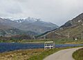
View along the glen across Loch Beannacharan, with Sgùrr na Lapaich beyond
-
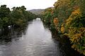
River Farrar at Struy
-
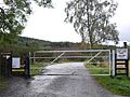
Locked gate
