Sgùrr a' Choire Ghlais facts for kids
Quick facts for kids Sgurr a' Choire Ghlais |
|
|---|---|

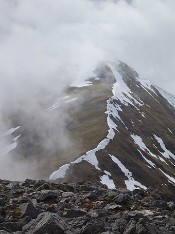
The north-east ridge
|
|
| Highest point | |
| Elevation | 1,083 m (3,553 ft) |
| Prominence | 818 m (2,684 ft) Ranked 31st in British Isles |
| Parent peak | Sgurr na Lapaich |
| Listing | Munro, Marilyn |
| Naming | |
| English translation | Rocky Peak of the Grey Corrie |
| Language of name | Gaelic |
| Pronunciation | English approximation: skoor-Ə-cor-YƏ-glash |
| Geography | |
| Location | Glen Strathfarrar, Scotland |
| OS grid | NH259430 |
| Topo map | OS Landranger 25 |
Sgurr a' Choire Ghlais is a tall mountain located in the North-west Scottish Highlands. It sits between two valleys, Glen Strathfarrar and Glen Orrin. This mountain is a fantastic spot for views because it's the highest peak in its area.
Other important mountains nearby include the Munros of Sgurr na Ruaidhe, Sgurr Fhuar-thuill, and Carn nan Gobhar. Looking north from Sgurr a' Choire Ghlais, there are no higher mountains until you reach the Fannaichs range.
Contents
What is Sgurr a' Choire Ghlais?
Sgurr a' Choire Ghlais is a mountain in Scotland. Its name comes from the Gaelic words meaning "Rocky Peak of the Grey Corrie." A "corrie" is a bowl-shaped hollow on a mountainside.
How tall is Sgurr a' Choire Ghlais?
This mountain stands 1,083 meters (about 3,553 feet) high. This makes it one of the tallest mountains in the British Isles. It is also known as a Munro, which is a Scottish mountain over 3,000 feet (914.4 meters) tall.
Where is Sgurr a' Choire Ghlais located?
Sgurr a' Choire Ghlais is found in the Scottish Highlands. It is part of a group of mountains in the Glen Strathfarrar area. Its exact location can be found using the grid reference NH259430.
Getting to Sgurr a' Choire Ghlais
Reaching Sgurr a' Choire Ghlais can be quite a challenge. It is one of the more difficult mountains to access in Scotland. The shortest way to get there involves a long journey.
What is the shortest route?
The shortest path to the mountain starts with a 10-mile walk up Glen Strathfarrar. This can be a very long hike. To make the journey shorter, you might use a bicycle. Another option is to get special permission to drive along the private road that goes up Strathfarrar.
 | Madam C. J. Walker |
 | Janet Emerson Bashen |
 | Annie Turnbo Malone |
 | Maggie L. Walker |

