Maoile Lunndaidh facts for kids
Quick facts for kids Maoile Lunndaidh |
|
|---|---|

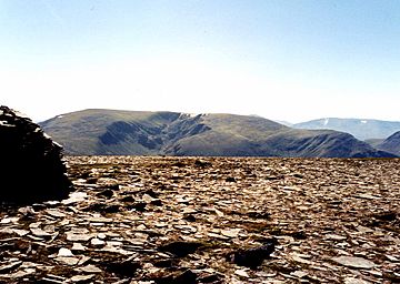
Maoile Lunndaidh seen from Mòruisg, five km to the NW. The massive corrie of Fuar Tholl Mòr can also be seen.
|
|
| Highest point | |
| Elevation | 1,007 m (3,304 ft) |
| Prominence | 10.5 m (34 ft) |
| Listing | Munro, Marilyn |
| Naming | |
| English translation | Bare hill of the wet place |
| Language of name | Gaelic |
| Pronunciation | English approximation: MUUL-ə-LOON-tee |
| Geography | |
| Parent range | Northwest Highlands |
| OS grid | NH135458 |
| Topo map | OS Landranger 25, OS Explorer 430 |
| Listed summits of Maoile Lunndaidh | ||||
| Name | Grid ref | Height | Status | |
|---|---|---|---|---|
| Carn nan Fiaclan | NH123455 | 993 m (3258 ft) | Munro Top | |
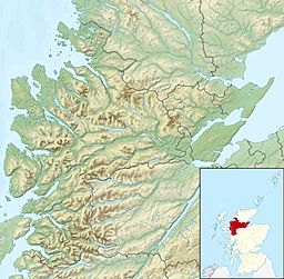
Maoile Lunndaidh is a large mountain in Scotland. It is located about 13 kilometers south of Achnasheen. This mountain is found in the Ross and Cromarty area of the Highland region. It sits between two large bodies of water, Loch Monar and Gleann Fhiodhaig.
About Maoile Lunndaidh
Maoile Lunndaidh is a very big and remote mountain. It covers more than 25 square kilometers. It is far from any main roads, about 10 kilometers away. This makes it a quiet and wild place.
The mountain is listed as a Munro. A Munro is a Scottish mountain over 914.4 meters (3,000 feet) high. Maoile Lunndaidh is 1007 meters (3304 feet) tall. This height was first set in the 1970s by the Ordnance Survey maps. Newer maps show it as 1005 meters.
Maoile Lunndaidh is known for its flat top. Its summit area is very wide and flat, like the Cairngorms mountains. This is unusual for mountains on the west coast of Scotland.
The mountain has two huge, bowl-shaped hollows called corries. These corries cut deep into the mountain on its northwest and southeast sides. They are the most striking features of Maoile Lunndaidh.
The name Maoile Lunndaidh comes from the Gaelic language. It means "Bare hill of the wet place." This name fits well because the lower parts of the mountain can be very boggy. Several small lakes, called lochans, are found high up in its corries.
Mountain Features
Maoile Lunndaidh's flat top ridge is almost 2 kilometers long. It never drops below 980 meters in height. Because it is so flat, people have sometimes been confused about its exact highest point. The official highest point has changed a few times on maps.
A nearby peak, Càrn nan Fiaclan, is 993 meters high. Its name means "Cairn of the teeth." It is considered a "Munro Top," which means it's a peak close to a Munro that is also very high.
The mountain's top ridge follows the edges of two large corries. These are the Fuar Tholl Mòr and the Toll a’ Choin. Fuar Tholl Mòr means "Big cold hollow." Toll a’ Choin means "Boggy hollow." They are impressive features of the mountain.
To the west, Maoile Lunndaidh is connected to another Munro called Sgurr a’ Chaorachain. They are linked by a lower area called a col, which is 605 meters high. To the east, a col of 490 meters connects it to An Sidhean, which is a Corbett. Corbetts are Scottish mountains between 762 and 914.4 meters high.
Inside Fuar Tholl Mòr, there are several small lochans. On the eastern side of the mountain, you can find larger lochs like Loch a’ Chlaidheimh and Loch nam Breac Dearga.
The southern slopes of Maoile Lunndaidh go down to Loch Monar. A long time ago, a village called Strathmore Lodge was located here. However, in the late 1950s, the loch's water level was raised to create Hydroelectricity. This caused the village and many homes to be covered by water. All the water from Maoile Lunndaidh flows towards the east coast of Scotland. It travels through long valleys like Strathfarrar and Strathconon. Eventually, it reaches the Beauly Firth and the Cromarty Firth.
Climbing Maoile Lunndaidh
Climbing Maoile Lunndaidh takes a full day. The paths are usually easy to follow. Many guidebooks suggest starting from Craig in Glen Carron. This route is a bit shorter. You can even use a bicycle for the first 10 kilometers to Glenuaig Lodge.
Other climbers prefer starting from Glen Strathfarrar because of the beautiful views. The route from Craig begins on the A890 road. From there, a track leads to the remote Glenuaig Lodge. You can then climb the mountain by following the western edge of the Fuar Tholl Mòr corrie.
Another way to climb is from the Loch Monar dam. This is a 22-kilometer round trip. You can drive part of the way on a private road. This walk follows the north shore of the loch for 6 kilometers. Then, you climb the mountain along its southeast ridge.
The very top of Maoile Lunndaidh has a large pile of grey rocks called a cairn. The summit area can be tricky to navigate if there is mist or fog. It is often mossy and stony.
 | William M. Jackson |
 | Juan E. Gilbert |
 | Neil deGrasse Tyson |


